Clariden
The Clariden is a mountain in the Glarus Alps, located at an elevation of 3,267 m (10,719 ft) between the Swiss cantons of Uri and Glarus. While on the north the Clariden overlooks the 1,948 m (6,391 ft) high Klausen Pass, the south side is covered by large glaciers. The Hüfifirn on the west is drained by the Chärstelenbach, a tributary of the Reuss that eventually flows into Lake Lucerne. The Claridenfirn on the east is drained by the Linth that eventually flows into Lake Zürich.[2]
| Clariden | |
|---|---|
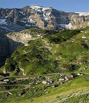 The Clariden above Klausen Pass | |
| Highest point | |
| Elevation | 3,267 m (10,719 ft) |
| Prominence | 413 m (1,355 ft) [1] |
| Parent peak | Schärhorn |
| Coordinates | 46°50′31.5″N 08°52′16.5″E |
| Geography | |
 Clariden Location in Switzerland | |
| Country | Switzerland |
| Canton | Glarus and Uri, |
| Parent range | Glarus Alps |
| Topo map | Swiss Federal Office of Topography swisstopo |
The mountain lies in the municipalities of Silenen and Spiringen, in the canton of Schwyz, and Glarus Süd, in the canton of Glarus. The nearest settlements are the villages of Unterschächen to the north-west, and Linthal to the north-east, which lie at each end of the Klausen Pass.[2]
References
- Retrieved from the Swisstopo topographic maps. The key col is the Chammlilücke (2,854 m).
- map.geo.admin.ch (Map). Swiss Confederation. Retrieved 2015-06-03.
External links

- Clariden on Summitpost
- Clariden on Hikr