City of Ventura Historic Landmarks and Districts
The City of Ventura Historic Landmarks and Districts consist of buildings, sites, and neighborhoods designated by the City of Ventura, California, as historic landmarks and districts.[1]

The first six sites designated as Ventura Historic Landmarks (VHL) were selected in February 1974. They are: the Olivas Adobe (VHL No. 1), the Ortega Adobe (VHL No. 2), the Father Serra statue (VHL No. 3), Ventura City Hall (VHL No. 4), the Grant Park cross site (VHL No. 5), and the Mission Plaza archeological site (VHL No. 6). In July 1974, the City also designated a second group of landmarks, including the Conklin residence (VHL No. 7), the Mission San Buenaventura (VHL No. 10), the Mission's Norfolk pine trees (VHL No. 8), and two large Moreton Bay fig trees located in city parks (VHL Nos. 11-12).[1]
As of April 10, 2018, the City had designated 111 sites as Ventura Historic Landmarks and five areas as Ventura Historic Districts.[1] The first historic district designated by the city was the Mission Historic District, extending from Poli Street at the northern border to Santa Clara Street at the southern border, and from Ventura Avenue on the west to Palm Street on the east. The Mission Historic District consists of the oldest section of the city's downtown area and includes more than 10 historic landmarks, including the Mission, the Mission Plaza archeological site, the Mission's Norfolk pines, the Mission Plaza Moreton Bay fig tree, Peirano Store (VHL No. 32), the Carlo Hahn House (VHL No. 78), the Mission Lavanderia (VHL No. 85), and China Alley (VHL No. 91).
A map depicting the location of Ventura's designated historic landmarks and districts can be viewed by clicking "OpenStreetMap" or "Google Maps" in the template found to the right below.
Ventura Historic Landmarks
| VHL No. | Name | Image | Address | Date listed | Description |
| 1 | Olivas Adobe | .jpg) | 4200 Olivas Park Drive 34.243796°N 119.243321°W | 2/11/74 | A one-story adobe structure was built in 1837 and expanded in 1849 by Don Raimundo Olivas; listed on the National Register of Historic Places in 1979 and designated as California Historical Landmark No. 115; operated as a museum |
| 2 | Ortega Adobe | 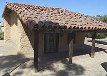 | 215 W. Main St. 34.281683°N 119.304127°W | 2/11/74 | Adobe structure first built in 1857; the roof of the adobe used tiles from the Mission after the 1857 Fort Tejon earthquake; it became the first home of the Ortega chili company; open to public for self-guided tours |
| 3 | Father Serra statue | 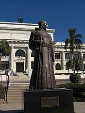 | 501 Poli St. 34.281874°N 119.293036°W | 2/11/74 | Concrete statue of Junípero Serra located in front of Ventura City Hall, replaced in 1989 with a bronze cast; a wooden replica created in 1988 is displayed in the atrium of City Hall |
| 4 | Ventura City Hall | .jpg) | 501 Poli St. 34.282352°N 119.293036°W | 2/11/74 | Neoclassical courthouse built in 1912, designed by Albert C. Martin Sr.; became Ventura City Hall in 1972; terra cotta exterior decorations, friars' heads, and copper-sheathed dome; listed on the National Register of Historic Places in 1971 (first site in City of Ventura to be so designated) and designated as California Historical Landmark No. 847 and Ventura County Historical Landmark No. 12 |
| 5 | Grant Park cross site |  | Ferro Drive 34.284602°N 119.296213°W | 2/11/74 | Site in Grant Park where a cross has been located for many year; some accounts indicate that the first cross was erected in 1782; the cross has been replaced several times, most recently in 1941[2] |
| 6 | Mission Plaza archeological site | .jpg) | 100 Block E. Main St. 34.281038°N 119.299018°W | 2/11/74 | A one-and-a-half acre archaeological site west of the Mission San Buenaventura; the Albinger Museum is part of the site[3] |
| 7 | Conklin residence | .jpg) | 608 E. Thompson Blvd. 34.278090°N 119.291340°W | 5/6/74 | Cape Cod style house originally built in 1877; part of the Mitchell Block Historic District |
| 8 | Mission Norfolk Pines | .jpg) | 211 E. Main St. 34.281181°N 119.298076°W | 7/1/74 | Norfolk Island pine trees (araucaria excilas) located adjacent to the San Buenaventura Mission, planted in the 1880s, lit during the Christmas season; designated in 2000 as California's Millennium Landmark Trees |
| 9 | Mound Pepper Tree | 5430 Telegraph Rd. | 7/1/74 | Pepper tree formerly located on site of the Mound Guest House; had a trunk circumference of 23.5 feet, a height of 43 feet, and a branch spread of 100 feet; no longer exists | |
| 10 | Mission San Buenaventura | 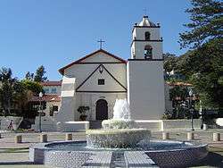 | 211 E. Main St. 34.281233°N 119.298241°W | 7/1/74 | The ninth Spanish mission established in California, established in 1782 by Father Junípero Serra; also listed on the National Register of Historic Places in 1975 and designated as California Historical Landmark #310 |
| 11 | Plaza Park Moreton Bay Fig Tree | 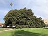 | Corner of Chestnut and Santa Clara Streets 34.279379°N 119.291309°W | 7/1/74 | Ficus macrophylla planted in 1874, 68 feet high with 130 foot branch spread[4] |
| 12 | Mission Plaza Moreton Bay Fig Tree | 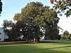 | 100 block E. Main St. 34.280500°N 119.298443°W | 7/1/74 | Ficus macrophylla circa 1874, part of the Mission district on the National Register of Historic Places |
| 13 | Baker residence | .jpg) | 2107 Poli St. 34.279742°N 119.268283°W | 9/23/75 | Victorian house built in 1888 |
| 14 | Judge Ewing residence | 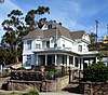 | 605 Poli St. 34.282337°N 119.291296°W | 9/23/75 | Queen Anne revival style house with wrap-around porch built in 1894; the interior includes a library with carved paneling and tile floors |
| 15 | Theodore Groene Building | .jpg) | 592 E. Main St. 34.280603°N 119.291801°W | 10/27/75 | Built in 1920s for Ventura Guarantee and Loan, later became Bahn's Jewelry Store, now operated as Limon y Sal; has interior murals by Norman Kennedy; original white paint removed 1982 |
| 16 | San Miguel Chapel Site | 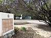 | Thompson Blvd. and Palm St. 34.278057°N 119.298168°W | 10/27/75 | Archaeological site at the location of the first outpost and center of operations that was established while the Mission San Buenaventura was being constructed |
| 17 | First Baptist Church of Ventura |  | 101 S. Laurel St. 34.279307°N 119.285688°W | 12/1/75 | Mayan Revival church built in 1931, now operated as the Ventura Center for Spiritual Living; listed on the National Register of Historic Places in 2009 |
| 18 | Shisholop Village Site/Cabrillo's Landing | Beachfront at south end of Figueroa Street | 12/22/75 | Site of Chumash village settled after 1000 A.D.; visited by Juan Rodríguez Cabrillo in 1542 | |
| 19 | Elizabeth Bard Memorial Hospital | 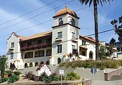 | 121 N. Fir St. 34.282454°N 119.290501°W | 3/8/76 | Opened as a hospital in 1902, now an office building; design is Mission Revival; listed on the National Register of Historic Places in 1977 |
| 20 | Ventura Pier | 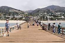 | Harbor Blvd. east of California St. 34.273909°N 119.291600°W | 3/29/76 | Wooden wharf first built in 1872, partially destroyed and rebuilt on multiple occasions; it was the longest wooden pier in California until a storm sheered off 420 feet in 1995 |
| 21 | Emmanuel Franz House | 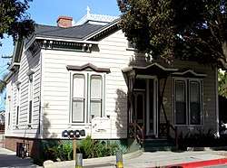 | 31 N. Oak St. 34.281344°N 119.294789°W | 3/29/76 | Italianate style house built in 1879; listed on the National Register of Historic Places in 1982 |
| 22 | Magnolia tree | 739 E. Santa Clara St. | 3/29/76 | Removed in 2002 | |
| 23 | Great Pacific Iron Works | .jpg) | 235 W. Santa Clara St. 34.279826°N 119.304048°W | 10/4/76 | Originally operated as Hobson Brothers meat packing business, now owned and operated by Patagonia |
| 24 | Ventura Theatre | 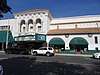 | 26 S. Chestnut St. 34.280425°N 119.291462°W | 10/4/76 | Movie palace built in 1928, now a live music venue; listed on the National Register of Historic Places in 1986[5][6] |
| 25 | First Post Office Building | .jpg) | 377 E. Main St. 34.281045°N 119.295062°W | 10/4/76 | Built in 1902, used as Post Office until 1919; Cafe du Suro bakery now operates on the ground floor with offices on the second floor |
| 26 | Hitching post | 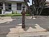 | 88 N. Ann St. 34.281908°N 119.284053°W | 10/4/76 | Last hitching post in the city |
| 27 | Apostolic Church | .jpg) | 902 E. Main St. 34.280653°N 119.286788°W | 12/20/76 | Originally operated as the Alice Bartlett Club |
| 28 | Southern Methodist Episcopal Church | .jpg) | 896 E. Main St. 34.280554°N 119.287142°W | 7/11/77 | Built in 1890, later operated as Victorian Rose Bed & Breakfast |
| 29 | Post Office murals | .jpg) | 675 E. Santa Clara St. 34.279935°N 119.290274°W | 10/24/77 | Painted 1936-1937 by Gordon Grant as part of the Works Progress Administration's Federal Art Project |
| 30 | Livery/county garage | .jpg) | 34 N. Palm St. 34.281332°N 119.295932°W | 11/21/77 | Began use in 1875 as a livery stable; used as a studio for the carving of a wooden replica of the Father Serra statue; has also been used as a coffeehouse music venue,[7] an arts center, and, later, as an improvisational comedy theater |
| 31 | Packard Garage | 42 N. Chestnut St. 34.279935°N 119.290274°W | 11/21/77 | Built in 1925 as an automobile show room, now headquarters of The Trade Desk | |
| 32 | Peirano Store | 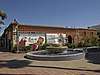 | 204 E. Main St. 34.280607°N 119.297602°W | 1/16/78 | Red brick structure built in 1877 with ornamental relief brickwork; the City's oldest surviving brick structure; operated as a general merchandise and, later, grocery store by the Peirano family for more than 100 years; archaeological remains of the Mission Lavanderia (VHL 85) discovered under the structure in 1991 |
| 33 | Peirano residence | 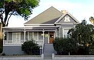 | 107 S. Figueroa St. 34.279344°N 119.297992°W | 1/16/78 | Occupied by the Peirano family from 1897 to 1976 |
| 34 | Theodosia Burr Shepherd Gardens | 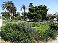 | SE corner of Poli and Chestnut 34.281874°N 119.291329°W | 7/17/78 | Garden of a famous horticulturalist; only remaining plants are a star pine and birds of paradise |
| 35 | Feraud General Merchandise Store | 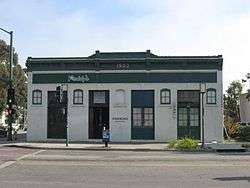 | 2 W. Main St. 34.280893°N 119.300961°W | 7/17/78 | Bakery and grocery store opened in 1903, now operated as Paddy's Bar and Lounge; also listed on the National Register of Historic Places in 1986 |
| 36 | First National Bank of Ventura (1904) | 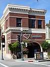 | 401 E. Main St. 34.281108°N 119.294517°W | 8/13/78 | Built in 1903 as first location for First National Bank of Ventura; the shop Latitudes now operates on the ground floor |
| 37 | First National Bank of Ventura (1926) | .jpg) | 494 E. Main St. 34.280620°N 119.293212°W | 10/16/78 | Operated by various banks, later retail; ground floor underwent restoration work in 2017 |
| 38 | Bank of Italy Building | .jpg) | 394 E. Main St. 34.280540°N 119.294856°W | 12/4/78 | Built 1923-24 in Italian Renaissance revival style; Corinthian columns and elaborate terra cotta carvings on facade |
| 39 | Dr. T. E. Cunnane Residence | 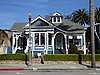 | 128 S. California St. 34.279099°N 119.292793°W | 12/18/78 | Queen Anne revival cottage style home |
| 40 | A. C. Martin Building (Bella Maggiore Inn) | 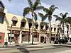 | 69 S. California St. 34.279914°N 119.293307°W | 4/9/79 | Spanish Renaissance style building designed by Albert C. Martin Sr., built in 1926, operated as the Bella Maggiore Inn |
| 41 | Robert Sudden residence | .jpg) | 825 Front St. 34.277223°N 119.288050°W | 4/9/79 | Built in 1886, moved in 1916 |
| 42 | Robert M. Sheridan Residence | .jpg) | 1029 Poli St. 34.282435°N 119.284976°W | 5/21/79 | American Craftsman bungalow |
| 43 | Chaffee & McKeeby / Einstein & Bernheim | Main St. & Palm St. | 5/21/79 | Commercial structure built in 1872, it housed two general merchandise stores and later the Great Eastern Department Store; at the southeast corner where Rabo Bank now operates; demolished in December 1979 | |
| 44 | Dudley House | 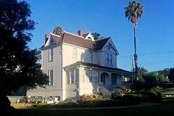 | 197 N. Ashwood Ave. 34.277641°N 119.240261°W | 1/21/80 | 1892 Victorian farmhouse now operated by San Buenaventura Heritage, Inc., as an event venue; listed on the National Register of Historic Places in 1977 |
| 45 | Righetti House | .jpg) | 125 W. Park Row Ave. 34.285106°N 119.301688°W | 1/21/80 | Queen Anne revival house with Classical Revival elements |
| 46 | Selwyn Shaw House | 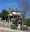 | 140 N. Ann St. 34.282646°N 119.283648°W | 1/21/80 | Queen Anne revival house built in 1888; part of the Selwyn Shaw Historic District |
| 47 | Jacques Roos House | 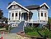 | 82 S. Ash St. 34.279820°N 119.288209°W | 3/17/80 | Queen Anne revival cottage style home with Eastlake influences, built in 1892 |
| 48 | Dacy Fazio House | .jpg) | 557 E. Thompson Blvd. 34.278517°N 119.292196°W | 4/14/80 | American Craftsman bungalow built in 1910 |
| 49 | Terry House | .jpg) | 4949 Foothill Rd. 34.283998°N 119.229422°W | 7/14/80 | Farm house built in 1917, once operated as a Unitarian church |
| 50 | Bert Shaw House | .jpg) | 1141 Poli St. 34.282329°N 119.283307°W | 9/15/80 | Victorian house built in 1896 with a modified Palladian window on the front |
| 51 | Blackstock House | .jpg) | 835 E. Main St. 34.281099°N 119.287969°W | 9/15/80 | Built in 1901 on the site of city hall, moved in 1911 to its present site |
| 52 | Sifford House | 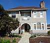 | 162 S. Ash St. 34.278788°N 119.288209°W | 9/15/80 | Built in 1895, includes a portico columned front door, framed by a horseshoe shaped arch |
| 53 | Nellie Clover House | 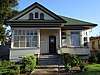 | 857 E. Main St. 34.281073°N 119.287664°W | 11/80 | Turn of the century cottage with Italianate cornice and Corinthian columns; later an office for Ventura County Jewish Family Service |
| 54 | Kimball House | 7891 E. Telephone Rd. 34.269200°N 119.187756°W | 7/81 | Built in 1928, house has Colonial and Mission elements | |
| 55 | Dunning House | .jpg) | 932 E. Main St. 34.280559°N 119.286439°W | 9/81 | California bungalow built approximately 1920 |
| 56 | Granger House | .jpg) | 1206 E. Main St. 34.280669°N 119.282218°W | 1/82 | Victorian house with high-pitched hipped roof topped with iron cresting and intersecting gables |
| 57 | Morrison House | .jpg) | 331 Poli St. 34.282351°N 119.295833°W | 5/18/82 | Victorian house with Eastlake details; the house was originally located at 1785 N. Ventura Avenue and was moved in 1985 |
| 58 | San Buenaventura Mission Aqueduct | 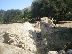 | East end of Vince and Lewis Streets | 8/2/82 | Seven-mile long aqueduct built starting in 1792 to supply water to the Mission San Buenaventura and local farms; the aqueduct began at the convergence point of San Antonio Creek and the Ventura River. The section of the aqueduct in the photograph is located at 234 Cañada Larga Road (south side), 1/4 block east of Highway 33, and has been listed on the National Register of Historic Places and designated as Ventura County Historical Landmark No. 28 and California Historic Landmark No. 114. |
| 59 | Blackburn House | .jpg) | 721 E. Main St. 34.281066°N 119.289633°W | 1/9/84 | Queen Anne revival house with Colonial Revival elements built in 1896; now offices for McCarthy Companies |
| 60 | Alessandro Lagoon | Vista Del Mar Dr. & Alessandro Dr. 34.272902°N 119.280795°W | 12/82 | Known in the late 19th and early 20th centuries as Chautaqua Flats, the area was camping and amusement enterprises; later a freshwater refuge on the Pacific Flyway; the seven-acre site extends east from the junction of Vista Del Mar and Alessandro Drives for about three-tenths of a mile along Alessandro Drive to the west of the northern border fence for Highway 101. | |
| 61 | Elwell House | .jpg) | 143 S. Figueroa St. 34.278938°N 119.297966°W | 3/7/85 | Built in 1892, now used as offices |
| 62 | Suyter House | .jpg) | 1157 Poli St. 34.282340°N 119.283106°W | 4/22/85 | Queen Anne revival style house built by Selwyn Shaw, 1890-91; part of the Selwyn Shaw Historic District |
| 63 | El Jardin Patio Bldg. | 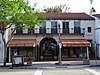 | 451-461 E. Main St. 34.281008°N 119.293848°W | Two-story shopping court built in the 1920s; an archway on Main Street leads into the landscaped courtyard | |
| 64 | Robert Brakey Residence | 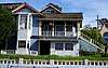 | 413 Poli St. 34.282347°N 119.294544°W | 10/14/85 | Victorian house built in 1890, later operated as the La Mer bed and breakfast |
| 65 | Judge Ben T. Williams House |  | 386 Franklin Lane 34.301419°N 119.288889°W | 1/26/87 | Queen Anne revival ranch house with Stick Eastlake influence built c. 1890; originally located on Ventura Avenue, but moved c. 1950 to Franklin Lane |
| 66 | Charles Corcoran House | .jpg) | 831 Buena Vista St. 34.282989°N 119.288072°W | 4/1/86 | Spanish Colonial Revival house built in 1930 |
| 67 | Charles Cooper House | .jpg) | 163 Cedar St. 34.282795°N 119.299146°W | 10/14/86 | Built in 1886 by a local carpenter |
| 68 | Josiah Keene House | 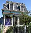 | 41 Bell Way 34.291369°N 119.298477°W | 9/28/87 | Second Empire/Victorian house with steep mansard roof built in 1872; also designated in 1970 as Ventura County Historical Landmark No. 33. |
| 69 | Hartman House | .jpg) | 73 N. Palm St. 34.281721°N 119.296423°W | 9/28/87 | American Craftsman bungalow built c. 1911 |
| 70 | J. A. Day House | 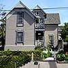 | 759 E. Poli St. 34.282333°N 119.289100°W | 4/25/88 | Victorian house built in 1889 in the Stick-Eastlake style |
| 71 | Ventura County Mutual Fire Insurance Co. Bldg. | .jpg) | 692 E. Main St. 34.280628°N 119.290234°W | 4/25/88 | Art Deco or Moderne style concrete office building with Aztec Revival flower elements designed by architect William W. Ache; later operated as a Mexican restaurant and then as the Fluid State bar |
| 72 | Erburu House | 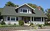 | 2465 Hall Canyon Rd. 34.280245°N 119.261792°W | 1/5/89 | American Craftsman bungalow built in 1909 |
| 73 | McCoskey Love House | 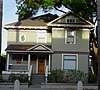 | 119 S. Figueroa St. 34.279153°N 119.298078°W | 7/17/89 | Victorian house with Italianate influence; originally located at corner of Chestnut and Santa Clara; now used as offices |
| 74 | Kate Duval House | .jpg) | 953 E. Main St. 34.281037°N 119.286237°W | 7/17/89 | Queen Anne revival cottage built in 1902 |
| 75 | J. Hoover Love House | 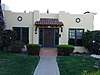 | 970 E. Santa Clara St. 34.279301°N 119.285939°W | 7/17/89 | House with Mediterranean Revival exterior and Arts and Crafts interior, built in 1923 |
| 76 | Mabel Nellie Owen House | 93 W. Simpson St. 34.288996°N 119.300083°W | 1/22/90 | Home of a local activist, designated as a landmark; located in the Simpson Tract. Owen and her husband bought the house at the end of World War II and lived there for many years.[8] | |
| 77 | Dr. Cephus Bard House | 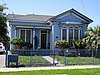 | 52 W. Mission Ave. 34.285335°N 119.300508°W | 4/1/91 | House built in 1886 for Ventura's first American doctor, who founded the Elizabeth Bard Hospital as a tribute to his mother |
| 78 | Carlo Hahn House | .jpg) | 211 E. Santa Clara St. 34.279780°N 119.297399°W | 7/15/91 | Victorian house built in 1905, then rebuilt and expanded in 1971; operated by a series of restaurants and bars ("Santa Clara House", "The Big Green House", "Andy's Barbecue Heaven," and most recently "The Tavern")[9] |
| 79 | Hammonds/Reese House | 637-639 Poli St. 34.282353°N 119.290861°W | 9/14/92 | Queen Anne revival house with Colonial Revival elements and a wraparound porch, built in 1905 | |
| 80 | Pierpont Inn | 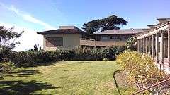 | 550 Sanjon Rd. 34.273432°N 119.283395°W | 2/1/93 | American Craftsman bungalow-style inn built in 1910 for motoring tourists |
| 81 | Arthur D. Briggs House | .jpg) | 856 E. Thompson Blvd. 34.278018°N 119.287664°W | 5/10/93 | Queen Anne style house built in 1894 |
| 82 | Tudor House | .jpg) | 301 S. Dunning St. 34.268701°N 119.251124°W | 10/13/93 | English Tudor revival house built in 1929 on hill overlooking the ocean |
| 83 | Arcade Building | 38-50 W. Main St. 34.280848°N 119.301479°W | 3/21/94 | Built in the 1920s, it has been operated as Dodge, Chrysler, Edsel, Jaguar, and vintage car dealerships | |
| 84 | Cassidy Dairy Ranch |  | 3908 Loma Vista Rd. 34.277271°N 119.242907°W | 5/16/94 | Colonial Revival house built by Selwyn Shaw in 1894 |
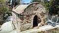
| 85 | San Buenaventura Mission Lavanderia | 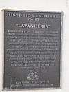 | 204-208 E. Main St. (underneath) 34.280615°N 119.297476°W | 11/14/94 | Archaeological remains of the Mission's lavanderia discovered in 1991 under storage rooms of the Peirano Market and Wilson Studio buildings |
| 86 | Erle Stanley Gardner Office | 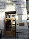 | 21 S. California St. 34.280369°N 119.293245°W | 2/6/95 | Law office of Erle Stanley Gardner, author of the Perry Mason books, was located at the northeast corner on the third floor |
| 87 | Casa de Anza | .jpg) | 606-612 N. Ventura Ave., 11-15 E. Simpson St. 34.288645°N 119.298242°W | 3/23/98 | Spanish Colonial Revival apartment building built in 1929 to house oil workers with retail on first floor; a city library branch now operates on the ground floor |
| 88 | WWII artillery emplacements | .jpg) | Near Ventura River Mouth 34.276369°N 119.309720°W | 9/98 | Camp Seaside artillery site built in 1942 in response to the Bombardment of Ellwood, a Japanese submarine attack on the Ellwood Oil Field; located on the west side of the Ventura River estuary within the borders of Emma Wood State Beach |
| 89 | Norton Ranch House |  | 71 N. Palm St. 34.281549°N 119.296409°W | 10/98 | American Craftsman style house built in 1910 on a walnut farm in east Ventura; moved to its present location in 1990 where it became a French restaurant (since closed) |
| 90 | John C. Fremont Camp | 100 Block E. Main Street | 1/11/99 | On January 5, 1847, during the Mexican–American War, John C. Frémont and elements of his California Battalion encamped in an orchard west of the Mission orchard's wall; there was a skirmish with locals in which a merchant, Don Jose Arnaz, was captured and forced to provide supplies. | |
| 91 | China Alley Historic Area | 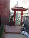 | 200 Block E. Main Street 34.280414°N 119.297633°W | Perpendicular to Figueroa Street between Main and Santa Clara Streets | Center of Chinese settlement and commercial activity starting in the early 1880s |
| 92 | Louis Rudolph Craftsman Bungalow |  | 958 E. Santa Clara St. 34.279333°N 119.286121°W | 3/02 | American Craftsman bungalow built in 1922 |
| 93 | Petit Tudor | .jpg) | 1725 Miramar Dr. 34.283614°N 119.272708°W | 10/02 | English Tudor house built in 1929, designed by John C. Austin |
| 94 | Rancho Attilio Site |  | 10814 Telephone Rd. 34.281862°N 119.153809°W | 3/27/06 | 117-acre ranch established in 1916 by Attilio Vanoni; associated with the development of the Saticoy area; the small parcel on Telephone Road is the site of the original Vanoni homestead |
| 95 | Mayfair Theater Site | 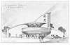 | 793 East Santa Clara St. 34.279672°N 119.288907°W | 3/27/06 | Site of Moderne movie palace designed by S. Charles Lee, it later became an adult theater; damaged by fire in 2000 and demolished in 2004 |
| 96 | Coast Live Oak Tree | Thompson Blvd. and Palm St. 34.278802°N 119.296362°W | 3/27/06 | Located at the southwest corner of the San Miguel Chapel site, a Coast Live Oak tree with a diameter of 52 inches | |
| 97 | Matthew H. Arnold Residence | .jpg) | 92 North Fir St. 34.281930°N 119.289774°W | 3/27/06 | Colonial Revival house built in 1907 |
| 98 | Lewis Rudolph Residence | .jpg) | 86 Encinal Place 34.280712°N 119.275364°W | 10/15/07 | Spanish Revival house built in 1927; the family of Olympic gold medalist Mike Larrabee lived in the house |
| 99 | Elks Ventura Lodge No. 1430 | 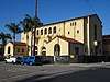 | 11 S. Ash St. 34.280473°N 119.288821°W | 5/5/08 | Spanish Colonial Revival structure built in 1928; occupied by the Benevolent and Protective Order of Elks from 1928 to 2004. |
| 100 | Ventura Avenue Water Purification Plant | 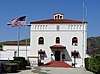 | 5895 N. Ventura Ave. 34.342960°N 119.293995°W | 2/5/08 | Spanish Colonial Revival administration building constructed in 1938; designated as well for representing the city's water development history |
| 101 | Harry S. Valentine House | 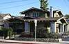 | 993 E. Santa Clara St. 34.279769°N 119.285667°W | 3/10/08 | Craftsman house with Oriental influences, built in 1915 |
| 102 | McGuire Building/Pythian Castle | 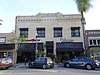 | 315-321 E. Main St. 34.281005°N 119.295844°W | Built 1906-1907, commercial structure includes decorative brick facade with a recessed X and O pattern and friezes | |
| 103 | Strickland Residence | .jpg) | 1660 Poli St. 34.281061°N 119.275092°W | 9/21/09 | Designated for association with notable women, including Florence Brigham and her daughter Helen Brigham |
| 104 | Hobart-Barr-Lucking Residence | 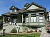 | 230 S. Ash St. 34.277864°N 119.288254°W | 7/19/10 | Colonial Revival house built between 1902 and 1906 |
| 105 | Thomas Gavin Gabbert Farmhouse | 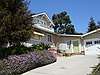 | 280 Parsons Ave. 34.280417°N 119.233418°W | 9/27/10 | Craftsman style farmhouse built between 1910 and 1914 |
| 106 | Lucking Residence | 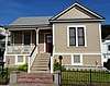 | 244 S. Ash St. 34.277706°N 119.288256°W | 8/6/12 | Colonial Revival house with a rock foundation and decorative wood posts, pilasters, carved dentils; built by Franklin and Julia Cook Hobart between 1892 and 1905 |
| 107 | Albert G. and Maude Shaffer Residence | .jpg) | 134 Chrisman Ave. 34.278101°N 119.277769°W | 10/21/13 | Spanish Colonial Revival house built in 1927 |
| 108 | Swift and Company Building | .jpg) | 305 S. Kalorama St. 34.276825°N 119.287142°W | 5/5/14 | Spanish Colonial with Mission Revival influences |
| 109 | Frederick Neill & Ida Foster Baker Residence | 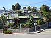 | 1093 Poli St. 34.282383°N 119.284123°W | 5/8/17 | Craftsman style house |
| 110 | The Mission Hotel building | .jpg) | 79-97 S. Oak St. 34.279739°N 119.294989°W | 5/8/17 | Built in 1926 in Spanish Colonial Revival style; a pawn shop and an antique doll shop currently operate on the ground level |
| 111 | The Hamilton Hotel (1924) | .jpg) | 363-367 E. Main St. 34.281025°N 119.295225°W | 5/8/17 | Commercial block built in 1924 with decorative brick facade with hotel name and letter "H" etched into recesses |
Ventura Historic Districts
| Name | Image | Boundaries | Description |
| Mission Historic District | | Santa Clara St. (south), Ventura Ave. (west), Poli St. (north), Palm Street (east) | The oldest section of downtown Ventura surrounding Mission San Buenaventura; the district includes more than 10 historic landmarks. |
| Mitchell Block Historic District | .jpg) | Plaza Park/Houses at 608, 620, 632, 644, 658, 670, 682 and 692 Thompson Boulevard 34.278078°N 119.290715°W | The district includes Plaza Park and the historic homes across Thompson Street from the park, including the Conklin Residence and the Mary Mitchell House; "the only intact and relatively unaltered block of houses remaining downtown"[10] |
| Selwyn Shaw Historic District | | Buena Vista St. (north), Ann St. (west), Hemlock St. (east), Poli St. (south) 34.282347°N 119.283097°W | City block northwest of downtown includes three historic landmarks: Selwyn Shaw House; Suyter House; and Bert Shaw House. |
| Simpson Tract Historic District | Sheridan Way (west), Ventura Avenue (east), W. Prospect St. (south), W. Simpson St. (north) 34.288139°N 119.300796°W | Four city blocks and 182 homes located west of Ventura Avenue, built from 1925 to 1930 provided affordable housing to workers during the city's oil boom; designated a historic district in 1990[11] | |
| Ivy Lawn Cemetery Historic District | 5400 Valentine Rd. 34.254546°N 119.215699°W | Cemetery deemed a historic district in 2013 for its architecture and as the burial place of historically-important people[12] |
Other designations
Other Ventura sites receiving historic designations:
- Thomas Gould Jr. House. American Craftsman style California bungalow at 402 Lynn Drive, built in 1924 and designed by Henry Greene of Greene and Greene. The house was listed on the National Register of Historic Places in 2005.
- Old Mission Reservoir. Part of the water system for Mission San Buenaventura (the settling tank or receiving reservoir; the site can be found in Eastwood Park); designated as California Historical Landmark No. 114.
- Santa Gertrudis Asistencia (Chapel) Monument. The structure was built in 1809 and ceased operation around 1840. The site was in the path of the Ojai freeway, and the remains were moved in 1968 with several foundation stones being used to create the monument. Located 0.3 miles north of the Avenue Water Treatment Facility (VHL 100) on the east side of the road, flanked by two cypress trees. Designated as Ventura County Historical Landmark No. 11 in December 1970.[13]
- Five Trees. Five blue gum eucalyptus trees on the hilltop overlooking Ventura were designated in 1987 as Ventura County Historical Landmark No. 110. Joseph Sexton planted a row of 13 trees in 1898, but a 1903 fire destroyed all but five of the trees. Three of the remaining trees were cut down by vandals in 1940 but were replaced. In 1956, four of the trees were cut down, leaving only one. Replacement trees were planted in 1966 but only two remain.[13]
See also
References
- "City of San Buenaventura Historic Landmarks & Districts". City of Ventura. May 3, 2016. Retrieved April 8, 2018. Note: The list available on-line has 108 landmarks. Landmarks 109, 110, and 111 were added in 2017 and are included in the updated list available at Ventura City Hall.
- Catherine Saillant (August 24, 2008). "Mission cross is a lasting Ventura landmark". Los Angeles Times. p. B2 – via Newspapers.com.
- Michele and Tom Grimm (November 22, 1981). "A Peek at the Past in Ventura". Los Angeles Times. p. VIII-8 – via Newspapers.com.
- Catherine Saillant (July 31, 2007). "Giant Ventura fig tree's fame may be its undoing". Los Angeles Times. p. B2 – via Newspapers.com.
- "A New Life Awaits Ventura Theater". Los Angeles Times. June 9, 1988. pp. X1, X5 – via Newspapers.com.
- "Old Venue Readies for Resurgence". Los Angeles Times. October 24, 1997. pp. B1, B5 – via Newspapers.com.
- "Bohemia at the Beach". Los Angeles Times. October 27, 1988. p. IX-2 – via Newspapers.com.
- "Home of Mabel Owen made historic landmark". unknown – via Research Library at the Ventura County Museum (clipping is in Binder 3 of the library's binders on the Ventura Historic Landmarks).
- "Andy's serves its fare in a restored home". Los Angeles Times. December 4, 1982.
- "On The Mitchell Block: City District Has a Niche in History". Los Angeles Times. March 20, 1990.
- "Simpson Tract Gets Historic Designation". Los Angeles Times. March 28, 1990.
- "Ivy Lawn designated as cemetery historic district". VC Reporter. October 17, 2013.
- "Ventura County Historical Landmarks & Points of Interest" (PDF). Ventura County Cultural Heritage Board. May 2016.