Chumysh
The Chumysh (Russian: Чумыш) is a river in Russia, a right branch of the Ob River.[1] It enters the Ob 88 kilometres (55 mi) downriver from Barnaul. The Chumysh begins at the confluence of the Kara-Chumysh and the Tom-Chumysh rivers in Kemerovo Oblast. The Chumysh is 644 kilometres (400 mi) long, and it drains a basin of 23,900 square kilometres (9,200 sq mi).[2]
| Chumysh | |
|---|---|
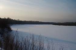 The Chumysh under the ice cover just before the confluence with the Ob, Yazovo village, Altai Krai | |
| Location | |
| Country | Russia |
| Physical characteristics | |
| Mouth | Ob |
⁃ coordinates | 53°32′25″N 83°10′04″E |
| Length | 644 km (400 mi) |
| Basin size | 23,900 km2 (9,200 sq mi) |
| Basin features | |
| Progression | Ob→ Kara Sea |
About 68 percent of its right-side basin is known as the Salair Ridge (Russian: Салаирский кряж) and the Pre-Salair plains.
Main tributaries
Left
- Kara-Chumysh (Кара-Чумыш), length 173 kilometres (107 mi)
- Sary-Chumysh (Сары-Чумыш), length 98 kilometres (61 mi)
- Kashkaragaikha (Кашкарагаиха), length 84 kilometres (52 mi)
- Taraba (Тараба), length 70 kilometres (43 mi)
- Yama (Яма), length 67 kilometres (42 mi)
- Angurep (Ангуреп), length 48 kilometres (30 mi)
Right
- Tom-Chumysh (Томь-Чумыш), length 110 kilometres (68 mi)
- Uksunay (Уксунай), length 165 kilometres (103 mi)
- Alambay (Аламбай), length 140 kilometres (87 mi)
- Sungay (Сунгай), length 103 kilometres (64 mi)
- Talmenka (Тальменка), length 99 kilometres (62 mi)
- Kamenka (Каменка), length 78 kilometres (48 mi)
References
- John P Rafferty, ed. (2011). Rivers and Streams. The Rosen Publishing Group. pp. 217–218. ISBN 1-61530-411-8.
- Река ЧУМЫШ in the State Water Register of Russia (Russian)
This article is issued from Wikipedia. The text is licensed under Creative Commons - Attribution - Sharealike. Additional terms may apply for the media files.