Chilecito
Chilecito is a city in the Argentine province of La Rioja, and head of the department of Chilecito.
Chilecito | |
|---|---|
 | |
 Chilecito Location of Chilecito in Argentina | |
| Coordinates: 29°10′S 67°30′W | |
| Country | |
| Province | La Rioja |
| Department | Chilecito |
| Founded | 1715 |
| Government | |
| • Mayor | Silvia del Valle Gaitan (Justicialist Party) |
| Elevation | 1,080 m (3,540 ft) |
| Population (2010 census) | |
| • Total | 33,724 |
| Demonym(s) | chileciteña/o |
| Time zone | UTC-3 (ART) |
| CPA base | F5360 |
| Area code(s) | 03825 |
| Climate | BWk |
Overview
The city is located in the valley formed by the Sierras de Velazco to the east, and the Sierras de Famatina to the west. The city was founded in 1715 by Spanish colonizers. Chilecito still preserves the cable-car of La Mejicana mine built by Bleichert which is part of the city mining past that saw its peak at the end of the 19th century.
Chilecito is surrounded by an oasis of irrigation, which has been expanded by way of supplements from underground waters. A great part of agricultural land is used for the cultivation of vineyards because the most significant industrial activity is based in wine-cellars. Walnut and fruit trees are also cultivated and their product is locally processed.
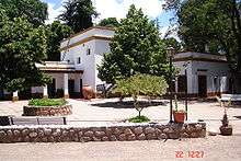
The Argentine educator, lawyer, senator, governor and historian Joaquín V. González was raised in the vicinity of Chilecito. He also used to spend his vacation in a home that he built here in his later years. The property, which he called Samay Huasi (Quechua Samay Wasi, "rest house") was donated to the University of La Plata for use as an artists' retreat.
By the end of the 1990s, the university of Chilecito which was still part of the National University of La Rioja became the National University of Chilecito. This decision was highly criticized by different academic and political sectors, especially those concerning to the President of Argentina at the time, Carlos Menem.
Population
According to statistics, Chilecito had 49,453 inhabitants (data taken from the 2010 census [INDEC]) which represents a 31% population increase in ten years (there were 22,485 inhabitants in 1991). These numbers include the nearby localities of Anguinán, Los Sarmientos, San Miguel and La Puntilla; without them, the population of Chilecito in 2001 was 25,423 inhabitants.
Climate
| Climate data for Chilecito (1961–1970, extremes 1961–2016) | |||||||||||||
|---|---|---|---|---|---|---|---|---|---|---|---|---|---|
| Month | Jan | Feb | Mar | Apr | May | Jun | Jul | Aug | Sep | Oct | Nov | Dec | Year |
| Record high °C (°F) | 43.1 (109.6) |
42.0 (107.6) |
40.5 (104.9) |
38.5 (101.3) |
38.2 (100.8) |
35.4 (95.7) |
34.9 (94.8) |
38.5 (101.3) |
40.0 (104.0) |
41.5 (106.7) |
43.7 (110.7) |
44.3 (111.7) |
44.3 (111.7) |
| Average high °C (°F) | 31.6 (88.9) |
30.2 (86.4) |
27.3 (81.1) |
24.8 (76.6) |
20.9 (69.6) |
17.2 (63.0) |
16.7 (62.1) |
19.8 (67.6) |
22.6 (72.7) |
26.0 (78.8) |
29.9 (85.8) |
31.6 (88.9) |
24.9 (76.8) |
| Daily mean °C (°F) | 24.1 (75.4) |
22.8 (73.0) |
20.0 (68.0) |
17.8 (64.0) |
13.9 (57.0) |
9.9 (49.8) |
9.1 (48.4) |
11.9 (53.4) |
14.8 (58.6) |
18.2 (64.8) |
21.2 (70.2) |
23.3 (73.9) |
17.3 (63.1) |
| Average low °C (°F) | 17.2 (63.0) |
16.3 (61.3) |
14.0 (57.2) |
11.5 (52.7) |
6.4 (43.5) |
2.7 (36.9) |
2.1 (35.8) |
4.2 (39.6) |
7.2 (45.0) |
10.5 (50.9) |
14.1 (57.4) |
16.1 (61.0) |
10.2 (50.4) |
| Record low °C (°F) | 9.3 (48.7) |
8.5 (47.3) |
2.4 (36.3) |
0.4 (32.7) |
−5.1 (22.8) |
−7.7 (18.1) |
−7.7 (18.1) |
−6.9 (19.6) |
−5.4 (22.3) |
−2.0 (28.4) |
1.3 (34.3) |
6.8 (44.2) |
−7.7 (18.1) |
| Average precipitation mm (inches) | 45 (1.8) |
31 (1.2) |
32 (1.3) |
9 (0.4) |
5 (0.2) |
6 (0.2) |
5 (0.2) |
4 (0.2) |
4 (0.2) |
5 (0.2) |
21 (0.8) |
22 (0.9) |
189 (7.4) |
| Average precipitation days | 4 | 4 | 4 | 2 | 1 | 1 | 1 | 0.7 | 0.9 | 1 | 3 | 3 | 25.6 |
| Average relative humidity (%) | 60 | 63 | 66 | 66 | 64 | 64 | 61 | 52 | 52 | 54 | 57 | 57 | 60 |
| Source: Servicio Meteorológico Nacional[1][2] | |||||||||||||
Remarkable people
- Juan Ramires de Velasco
- Joaquín V. González, née Joaquín Víctor González
- Mateo Rosas de Oquendo
- Julián Amatte
- Doña Nocenta Pizetta
- Francisco Antonio Ortiz de Ocampo
- Domingo de Castro y Bazán
- Sarmiento de la Vega
- Isabel Ibarra y Velasco de Sarmiento de la Vega
- Arturo Marasso
- Gabino Coria Peñaloza
References
- "Datos Estadísticos (Período 1961-1970)" (in Spanish). Servicio Meteorologico Nacional. Retrieved February 13, 2016.
- "Clima en la Argentina: Guia Climática por Chilecito Aero". Caracterización: Estadísticas de largo plazo (in Spanish). Servicio Meteorológico Nacional. Archived from the original on 4 September 2017. Retrieved 4 October 2017.