Chikodi
Chikkodi is a taluka and Town Municipal Council city in the Belgaum district of Karnataka, India. It is a Subdivision of the district. Chikodi, Athani, Hukkeri, Raybag, Nipani and Kagwad are the taluks that come under Chikodi Subdivision. It is 75 kilometers from the city of Belgaum, 65 kilometers from Kolhapur, 51 kilometers from Miraj, 160 kilometers from Hubballi, and 570 kilometers from the capital of Karnataka state, Bengaluru. Chikodi has many district level offices but it is not designated as a district by the Government of Karnataka. It is one of the major cities that lies in the border between Karnataka and Maharashtra states.
Chikkodi | |
|---|---|
City | |
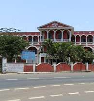 Mini Vidhanasoudha Chikodi | |
 Chikkodi Location in Karnataka, India | |
| Coordinates: 16.43°N 74.6°E | |
| Country | |
| State | Karnataka |
| District | Belgaum |
| Government | |
| • Member of Parliament (MP) | Annasaheb Shankar Jolle |
| • Member of Legislative Assembly (MLA) | Ganesh Prakash Hukkeri |
| Area | |
| • Total | 1,263 km2 (488 sq mi) |
| Elevation | 683 m (2,241 ft) |
| Population (2011) | |
| • Total | 40,000 |
| • Density | 32/km2 (82/sq mi) |
| Languages | |
| • Official | Kannada |
| Time zone | UTC+5:30 (IST) |
| PIN | 591201 |
| Telephone code | 08338 |
| Vehicle registration | KA-23 |
History
Around 200–300 years ago, Chikkodi was called as Chik-kodi (small village), while the nearby Hirekudi (big village) was bigger than Chikodi. Over time, Chikodi experienced growth due to its famous betel leaves and its position on major roads. Chikodi has always had strong religious ties for Jains, Hindus, Christians and Muslims. It enjoys rich cultural diversity stemming from its proximity to the state of Maharashtra. Kannada is the main language that is spoken though Marathi is spoken seldom too. The customs and traditions of Chikodi have been influenced by both the Kannadiga and Maratha cultures.
Geography
Chikodi is located at 16.43°N 74.6°E.[1] It has an average elevation of 683 meters (2240 feet). The town has an area of 18.29 km2, and is situated amidst hills. The topography within 2 kilometers of Chikodi contains significant variations in elevation as it is surrounded by range of hills, with a maximum elevation change of 169 meters and an average elevation above sea level of 657 meters.[2]. The Krishna river, which has water almost throughout the year, is the chief source of agricultural and drinking water for local people living in the surrounding villages. The other river system of the taluka consists of Vedganga, Dudhaganga and Panchganga. Ground water resources are also extensively tapped in foothills which are easily accessible to borewells, canals and creeks around. Nestling among the hillocks and sylvan surroundings, it is indeed an ideal place for trails and easy to moderate hikes. There's a famous telephone tower atop Chandrakori Hills which renders mesmerizing views of the city.
Chikodi taluka is generally divided into two zones on the basis of terrain. The Northern part consists of the deep and good black soil on the bank of the rivers flowing from west to east, therefore it is a very fertile tract. While the southern hilly area land consists of red clay soil, having comparatively less fertile. Of course, there are small patches of coarse land in northern part and good fertile land in the southern part of the taluka.
Climate
Chikodi has a tropical savanna climate. The wet season is pleasant, windy, and overcast while the dry season is hot and partly cloudy. The dry season lasts for 2.5 months, from March 9 to May 23, with an average daily high temperature above 34°C. Chikodi receives rainfall from both the northeast and the southwest monsoons and the wettest months are June–September.[3][4] The rainy period of the year lasts for 6.1 months, from May 14 to November 18, with a sliding 31-day rainfall of at least 13 millimeters. The most rain falls during the 31 days centered around July 18, with an average total accumulation of 239 millimeters. Over the course of the year, the temperature typically varies from 14°C to 37°C and is rarely below 13°C or above 39°C. December & January are generally cold as compared to the rest of year. The coldest month is January with an average low temperature of 14 °C and the hottest month is April with an average high temperature of 35.7 °C. Winter temperatures rarely drop below 13 °C (55.4 °F), and summer temperatures seldom exceed 38 °C.[5][6][7]
| Climate data for Chikodi | |||||||||||||
|---|---|---|---|---|---|---|---|---|---|---|---|---|---|
| Month | Jan | Feb | Mar | Apr | May | Jun | Jul | Aug | Sep | Oct | Nov | Dec | Year |
| Record high °C (°F) | 33.6 (92.5) |
36 (97) |
38.1 (100.6) |
40 (104) |
39.5 (103.1) |
37.1 (98.8) |
34.8 (94.6) |
34.1 (93.4) |
35.8 (96.4) |
34.2 (93.6) |
34.1 (93.4) |
35.2 (95.4) |
36.02 (96.84) |
| Average high °C (°F) | 29 (84) |
33.1 (91.6) |
34 (93) |
38 (100) |
37 (99) |
30 (86) |
28 (82) |
27 (81) |
28 (82) |
28 (82) |
29 (84) |
28 (82) |
30.84 (87.51) |
| Daily mean °C (°F) | 22 (72) |
25 (77) |
27 (81) |
29 (84) |
29 (84) |
25 (77) |
24 (75) |
23 (73) |
23 (73) |
23 (73) |
22 (72) |
22 (72) |
24.5 (76.1) |
| Average low °C (°F) | 14 (57) |
16 (61) |
19 (66) |
22 (72) |
24 (75) |
23 (73) |
22 (72) |
21 (70) |
19 (66) |
17 (63) |
15 (59) |
14 (57) |
18.83 (65.89) |
| Record low °C (°F) | 11.9 (53.4) |
13.9 (57.0) |
15.4 (59.7) |
16.7 (62.1) |
18.3 (64.9) |
19.1 (66.4) |
18.2 (64.8) |
17.9 (64.2) |
18.5 (65.3) |
18.4 (65.1) |
17.6 (63.7) |
14.1 (57.4) |
17.39 (63.30) |
| Average precipitation mm (inches) | 0.68 (0.03) |
0.8 (0.03) |
8.75 (0.34) |
3.94 (0.16) |
47.28 (1.86) |
81.52 (3.21) |
62.41 (2.46) |
56.67 (2.23) |
32.42 (1.28) |
55.4 (2.18) |
18.1 (0.71) |
5.6 (0.22) |
361.37 (14.23) |
| Average rainy days | 1 | 2 | 5 | 5 | 11 | 21 | 20 | 18 | 16 | 11 | 4 | 4 | 123 |
| Average relative humidity (%) | 41 | 31 | 38 | 41 | 58 | 77 | 86 | 91 | 81 | 61 | 55 | 52 | 59.33 |
| Mean monthly sunshine hours | 307 | 288.5 | 310 | 274.5 | 308 | 182.4 | 84.5 | 74 | 170.5 | 264.5 | 233.5 | 280 | 2,777.4 |
| Average ultraviolet index | 6 | 6 | 7 | 7 | 7 | 5 | 5 | 5 | 6 | 6 | 6 | 6 | 6 |
| Source 1: Monthly Weather Forecast[8][9] | |||||||||||||
| Source 2: Indian Meteorological Department[10][11][12] | |||||||||||||
Demographics
As of 2011 India census,[13] Chikodi had a population of 38,307. Males constitute 51% of the population and females 49%. The average literacy rate is 73%, higher than the national average of 59.5%; with male literacy at 79% and female literacy at 66%.
Business
Chikodi is mostly dependent on agriculture. Sugarcane occupies an important place in the economy of Chikodi which has three sugar factories, Doodhaganga Krishna Sugar Factory which is the nearest, Venkateshwara Power Project Ltd. Bedkihal, and Om Sugars Ltd. Jainapur among others. Tobacco farming is another major agricultural sector. Major production of tobacco comes from Galatga, Shiragaonwadi, Tapakarwadi, and Khadaklat villages. Recently the trend of Sericulture is picking up.
Renewable power projects at Chikodi
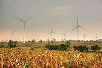
Wind power project
The project activity is a cleaner means for power generation which avoids fossil fuel based thermal power generation. It is an energy diversification measure where wind energy which is a renewable energy, is harnessed for generation of power in order to suffice the increasing energy demand in the villages around Chikodi. It will help to improve the availability of electricity as the electricity generated will be fed into the grid thereby curtailing the supply demand gap. The generated electricity is supplied to the Karnataka Power Transmission Corporation Limited (KPTCL) which distributes it as per the state policy. The land prices in the neighboring area have gone up thereby benefiting the villagers. Total nominal power expected is around 18 MW.[14]. A range of wind farms can be seen around a radius of 5 km from the city. Wind farms generate clean renewable electricity without any greenhouse gas emissions or waste byproducts thus mitigating climate change. This electricity displaces electricity generation in fossil fuel dominated grid resulting in savings of coal.[15]
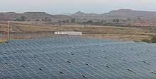
Solar power plant
A solar photovoltaic (PV) power plant in Itnal, Chikodi, was set up in the year 2009 by Karnataka Power Corporation Limited. The installed capacity of plant is 3 MW. There are totally 13,104 modules of each 250 MW rating in an area of 17 acres. Totally 12 Inverters of each 250KW rating are used to convert the generated DC voltage into AC Voltage. There are totally 3 three phase transformers of each with rating of 1MW. The generated power is sold to KPTCL. The plant has been established at a cost of Rs 60 Crore. It is catering for 80% of the region’s energy requirements with the 4000MWh it produces each year, thereby providing reliable power to the farmers in nearby villages.[16]. It is located near Umarani village at coordinates 16.401750,74.664067, about 11 km from Chikodi.
Tourism and attractions
- Chandrakori Ganesh Temple - situated on top of Chandrakori hill, is a very famous temple of lord Ganesha. This temple can be reached through well-paved steps laid from Indira nagar.
- Parati Nagalingeswara (Parati Nagappa) temple located about 2.5 km away from the Central bus stand, is one of the famous temples around the city.
- Yadur - Shree Veerbhadra temple is situated in the holy Shri Kshetra Yadur, on the banks of river Krishna located about 20 km from Chikodi
- Karoshi - Shree Basavanna temple (Ghatti Basavanna) is situated in the holy place of Karoshi, is located about 7 km from Chikodi. It has a famous Darga, also this indicates the communal harmony it has. This place is agriculturally sound.
- Shantigiri Jain Temple - It is about 10 km from Chikodi. This village is considered as one of the highlighted centers of Jain history, where Shri Shantigiri Tirth is also situated.
- Chinchani - Having Allamprabhu Sidd Sansthan Math, Shri Basaveshwar temple (Gudadagind Basavan) located about 5 km from Chikodi.
- Toranahalli- Famous for Bhagavan Hanuman temple located in this village, it is about 10 km from Chikodi.
- Shiragaon - Famous for Basaveshwara temple and it is near 11 km from Chikodi.
- Gokak Falls (Near Gokak) & Narsobawadi (Maharashtra) are also near to the city.
- Hidkal Dam - also known as Raja Lakhamagouda dam, is a dam constructed across the Ghataprabha River in the Krishna River basin. It is about 40 km from Chikodi.
- Basavanal Gadde- Lakkavva Temple in Laxmi Nagar is one of the oldest temples in around the town.
- Basavanal Gadde- Hanuman Temple in Hanuman Nagar is very famous in the region.
Education
Chikodi is considered as an education hub in Belagavi district for its educational institutions and facilities. Some of them are:
- CTE Society's R.D. Kannada & Marathi Medium Primary and High School
- CLE Society's M.K. Kavatagimath Kannada & English Medium Primary and High School
- GSES's English Medium Primary and High School
- CTE Society's International Public School (CBSE)
- CTE Society's R.M. Kannada & Marathi Medium Primary and High School for Girls
- CTE Society's English Medium School (CBSE)
- St. Francis of Assisi School (ICSE)
- Jawahar Navodaya Vidyalaya, Kuppanwadi, Chikodi taluka
- Sri Murughendra Residential School,Kuppanawadi, Kothali (Post) Chikodi
- Chikodi also has Government primary schools for boys and girls in Kannada, Marathi and Urdu Medium
- CTE Society's R.D Composite PU college of Arts,Commerce & Science
- KLE's PU college of Arts,Commerce & Science
- Chauson Education Society's Chauson PU College of Arts, Commerce & Science
- KLE's B.K College of Arts, Commerce & Science (B.A, B.com, B.Sc & M.com)
- KLE Independent Pre-University Science College
- CTE Society's Smt. A A Patil College of Arts & Commerce (BA,B.com) for Women
- CTE Society's College of Physical Education (BP.Ed)
- CTE Society's R D Job Oriented Course (JOC) College
- CTE Society's R D College of Education (B.Ed, D.Ed)
- CLE'S College of Education (B.Ed, D.Ed)
- CLE's PU College
- APTECH Computer Education Institute running since 1995.
- Chauson College of Education (B.Ed, D.Ed)
- Chikodi also has two Industrial Training Institute (ITI) Colleges
- KSS Shri Y.B.Kiwad English Medium Primary School
- KSS Smt. N.Y.Kiwad English Medium High School
- Government First Grade College, Chikodi
- Adarsha PARA MEDICAL Institute
- J.R.D Bhate PARA MEDICAL Institute
- KLE's Colleges of BBA, BCA and BBM
- KLE's Law College
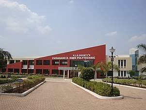
- KLE's C.B Kore College of Polytechnic
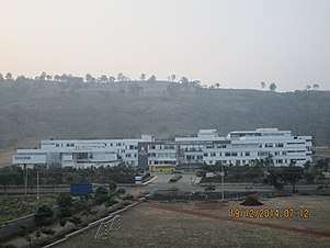
- KLE's College of Engineering and Technology, Chikodi
- Kendriya Vidyalaya, Chikodi
- Government Tool Room & Training Centre (GTTC).
There is also a proposal to start Sub-Regional Science Center and Automated driving test track in Chikodi.
Dispute regarding District status
Belagavi district is the largest district in the Karnataka so bifurcation of district is evident. Bifurcation of Belagavi district, which includes a total of 14 taluka's, has been a long pending issue. Government of Karnataka has already provided the District level offices to Chikodi which would help in the development of neighbouring talukas of Chikodi, Hukkeri, Athani, Raybag, Nipani, and Kagawad. But as of now, no decision has been made regarding bifurcation of Belagavi district and Government of Karnataka has not granted Chikodi a separate district status.
List of District Level Offices in Chikodi:-
1. Revenue Subdivision Office - 5 taluks
2. Regional Transport Office (RTO)[KA-23] - 6 taluks
3. Chikkodi Lok Sabha constituency - 8 MLA's
4. NWKRTC Divisional Office - 6 bus depots
5. Chikodi Postal Division - 5 taluks
6. District Health & Family Welfare Office - 8 taluks
7. Educational District (DDPI) Office - 8 BEO offices
8. District Irrigation Office - 6 taluks
9. Police Department (DCP/DYSP) Subdivision - 10 police stations
10. Karnataka Power Transmission Corporation Limited (KPTCL) - 5 taluks
11. Karnataka Public Works Department (PWD) - 8 taluks
12. Zilla Panchayat Executive Engineer Office - 8 taluks
13. Judicial District - 8 taluks
14. Animal Husbandry & Veterinary Services Department - 8 taluks
15. Deputy Director of Pre University (DDPU) Office - 5 taluks
16. Executive Engineer of the Rural Drinking Water Supply and Sanitation Department - 7 taluks
17. Post Office Passport Seva Kendra (POPSK), Chikodi.[17][18]
The attempts of the Government declaring Additional Superintendent of Police (SP) post for Chikodi.
Transport
Majority of public transport in Chikodi connecting surrounding villages and towns is through city buses run by North West Karnataka Road Transport Corporation (NWKRTC) from Chikodi central bus stand. Auto rickshaws are commonly available for commuting inside the city.
Road
Chikodi is well connected by road with major State Highways which connect to National Highway 48 which was earlier designated as NH 4 before all the National Highways were renumbered in the year 2010.[19]. The State Highways passing through Chikodi are: KA SH 18 (Mudhol to Nipani), KA SH 12 (Vijayapur to Sankeshwar) and SH 78 (Ichalakaranji to Hattargi).
State Highway 12 has been declared as the National Highway which goes from Sankeshwar to Vijayapur via Gotur-Chikodi-Kagawad-Athani-Tikota.
NWKRTC runs buses from Chikodi to all corners of Karnataka as well as neighboring states. Rajahamsa and A/C Sleeper coach services to Bengaluru daily.
There are many prominent private bus services like VRL, SRS, Manish, Shyamala and SEABIRD Travels from Chikodi to Bengaluru daily night. Ganesh and Sugama Tourist which operates daily night from Chikodi to Kundapur, Udupi, Moodabidre and Mangalore.
Rail
The closest railway station is Chikodi Road Station located at a distance of about 20 km (near Kabbur). This station falls under South Western Railway Zone.
Air
The closest airports are Belagavi Airport and Kolhapur Airport located at a distance of about 70 km and 60 km, respectively. And nearest international airport is Dabolin International Airport, Goa which located at a distance of 193 km.
See also
References
- Falling Rain Genomics, Inc - Chikodi
- "Chikodi Topography".
- "Southwest and Northeast monsoons in India". Dept. of Environment, Govt. of Maharashtra. Archived from the original on 18 December 2012. Retrieved 8 April 2018.
- "Southwest monsoon maps". mapsofindia.com.
- "Forecasting manuals for Southwest Monsoons". Indian Meteorological Department, Govt. of India. Archived from the original on 24 September 2015. Retrieved 18 December 2011.
- "Weather maps for surface temperature". myweather2.com. Retrieved 14 June 2012.
- "Weekly Rainfall predictions". Indian Meteorological Department, Govt. of India. Archived from the original on 24 September 2015. Retrieved 14 June 2012.
- "Chikodi Monthly Climate Averages".
- "Average monthly sunshine hours for Karnataka". worldreviewer.com.
- "Indian Meteorological Department". Indian Meteorological Department, Govt. of India. Archived from the original on 24 September 2015. Retrieved 1 September 2005.
- "Satellite Imaging for weather forecast". Indian Meteorological Department, Govt. of India. Archived from the original on 19 October 2015. Retrieved 5 June 2019.
- "Weather data from 1901–2000" (PDF). Indian Meteorological Department, Govt. of India. Archived from the original (PDF) on 13 April 2015. Retrieved August 25, 2011.
- "Census of India 2001: Data from the 2001 Census, including cities, villages and towns (Provisional)". Census Commission of India. Archived from the original on 16 June 2004. Retrieved 1 November 2008.
- "Wind Farms Chikodi, Karnataka".
- "Wind Power Project Chikodi".
- "Itnal Solar Power Plant, Chikodi".
- "Chikkodi too gets Passport Kendra - Times of India". The Times of India. 22 December 2018. Retrieved 22 December 2018.
- "Post Office Passport Seva Kendra".
- "National highway numbers to change, stretches to be longer - Times of India". The Times of India. 18 February 2010. Archived from the original on 19 February 2010. Retrieved 9 October 2017.
| Wikimedia Commons has media related to Chikodi. |