Chikaskia River
The Chikaskia River (usually pronounced chi-KAS-kee-uh but often pronounced chi-KAS-kee in southern Kansas) is a 159-mile-long (256 km)[2] tributary of the Salt Fork of the Arkansas River in southern Kansas and northern Oklahoma in the United States.[3] Via the Salt Fork and Arkansas rivers, it is part of the watershed of the Mississippi River.
| Chikaskia River | |
|---|---|
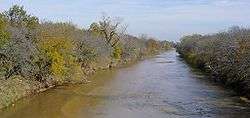 The Chikaskia River near the community of Corbin in Sumner County, Kansas | |
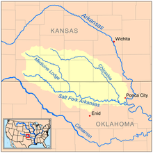 Map of the Salt Fork Arkansas watershed showing the Chikaskia River | |
| Location | |
| Country | United States |
| State | Kansas, Oklahoma |
| Region | Great Plains |
| Physical characteristics | |
| Source | |
| • location | Southwest Pratt County, Great Plains, Kansas, United States |
| • coordinates | 37°31′00″N 098°34′43″W[1] |
| • elevation | 925 ft (282 m) |
| Mouth | Salt Fork of the Arkansas River |
• location | Near Tonkawa, Oklahoma, United States |
• coordinates | 36°37′23″N 097°14′38″W[1] |
• elevation | 282 ft (86 m)[1] |
| Length | 159 mi (256 km), Southeast[2] |
| Basin features | |
| River system | Salt Fork of the Arkansas River watershed |
Course
The Chikaskia River begins as an intermittent stream in southwestern Pratt County, Kansas and initially flows eastwardly into Kingman County, where it turns southeastward for the remainder of its course through Harper and Sumner counties in Kansas and Grant and Kay counties in Oklahoma. In Kay County the river flows past the town of Blackwell and flows into the Salt Fork 5 miles (8 km) southeast of Tonkawa.[3][4][5]
Variant names
The United States Board on Geographic Names settled on "Chikaskia River" as the river's official name and spelling in 1897. According to the Geographic Names Information System, the river has also been known as "Chicaskia River", "Sha wa cas kah River", and "Sha-wa-cas-kah River."[6]
Fishing
The Chikaskia River and the Salt Fork are known for their large catfish.
See also
- List of Kansas rivers
- List of Oklahoma rivers
- USS Chikaskia (AO-54) is named after the river
References
- "Chikaskia River". Geographic Names Information System. United States Geological Survey. 1979-12-18. Retrieved 2013-08-17.
- U.S. Geological Survey. National Hydrography Dataset high-resolution flowline data. The National Map Archived 2012-04-05 at WebCite, accessed May 31, 2011
- Columbia Gazetteer of North America entry Archived November 27, 2004, at the Wayback Machine
- DeLorme (2003). Kansas Atlas & Gazetteer. Yarmouth, Maine: DeLorme. ISBN 0-89933-342-7.
- DeLorme (2003). Oklahoma Atlas & Gazetteer. Yarmouth, Maine: DeLorme. ISBN 0-89933-283-8.
- U.S. Geological Survey Geographic Names Information System: Chikaskia River