Chicón
Chicón[2] or Chicon[3][4] (possibly from Quechua ch'iqu workable stone) is a mountain in the Urubamba mountain range in the Andes of Peru, about 5,530 m (18,140 ft) high.[3][4] It is located in the Cusco Region, Calca Province, Calca District and in the Urubamba Province, Urubamba District. It is situated northeast of the town of Yucay, southeast of Pumahuanca and southwest of the Sirihuani.[3] The southern part of Chicón is also known as Illahuamán.[5][6] It belongs to the Yucay District. It reaches 5,060 m (16,601 ft).[6]
| Chicón | |
|---|---|
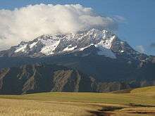 Mount Chicón as seen from the southwest | |
| Highest point | |
| Elevation | 5,530 m (18,140 ft) |
| Coordinates | 13°14′12″S 72°03′22″W |
| Geography | |
 Chicón Peru | |
| Location | Peru |
| Parent range | Andes, Urubamba |
| Climbing | |
| First ascent | 1-1958: Via prominent snow gully on S.face & ridge[1] |
External links
![]()
References
- Jill Neate, Mountaineering in the Andes, 1994
- "Nevado de Chicon". Inventario Turistico del Perú. MINCETUR. Archived from the original on 2015-06-25. Retrieved 2016-07-14.
- Peru 1:100 000, Urubamba (27-r). IGN (Instituto Geográfico Nacional - Perú).
- Biggar, John (2005). The Andes: A Guide for Climbers. Andes. p. 113. ISBN 9780953608720.
- Plan de Acondicionamiento Territorial 1ra Etapa Provincias de Calca y Urubamba - Diagnostico, Centro Guaman Poma de Ayala, June 2011, p. 70
- "Nevado de Illahuaman". mincetur. Archived from the original on August 15, 2016. Retrieved August 20, 2015.
This article is issued from Wikipedia. The text is licensed under Creative Commons - Attribution - Sharealike. Additional terms may apply for the media files.