Charlie Lake (British Columbia)
Charlie Lake is a lake in north-eastern British Columbia, Canada, situated 8 km (5.0 mi) west from Fort St. John, along the Alaska Highway. The lake provides the water supply for the city of Fort St. John.[2] The Charlie Lake Formation, a stratigraphical unit of the Western Canadian Sedimentary Basin is named for the lake.
| Charlie Lake | |
|---|---|
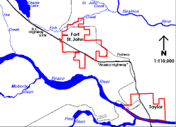 Charlie Lake situated north-west of Fort St. John | |
| Coordinates | 56.32484°N 120.97536°W |
| Primary inflows | Stoddart Creek |
| Primary outflows | Stoddart Creek |
| Basin countries | Canada |
| Max. length | 13 kilometers (8.1 mi)[1] |
| Max. width | 3 km (1.9 mi) |
| Surface elevation | 700 m (2,300 ft) |
| Settlements | Charlie Lake |
Geography
The lake is situated at an elevation of 700 m (2,300 ft). It is formed along the Stoddart Creek, a right tributary of the Beatton River, itself a major tributary of the Peace River.
Two parks are established on the shores of the lake, Charlie Lake Provincial Park[1] on the west shore, and Beatton Provincial Park on the east shore. The settlement of Charlie Lake lies at the southern tip of the lake.
See also
References
- BC parks. "Charlie Lake Provincial Park". Retrieved 2009-12-21.
- BC-Ministry of Environment. "AMBIENT WATER QUALITY FOR CHARLIE LAKE". Retrieved 2009-12-21.
This article is issued from Wikipedia. The text is licensed under Creative Commons - Attribution - Sharealike. Additional terms may apply for the media files.