Chamarajanagar
Chamarajanagar is a town in the southern part of Karnataka, India. Named after Chamaraja Wodeyar IX, the erstwhile king of Mysore, previously knows as 'Arikottara ' .it is located on the interstate highway linking the neighboring states of Tamil Nadu and Kerala.
Chamarajanagar Arikottara | |
|---|---|
City | |
 Chamarajanagar - Tirupati Express train at Chamarajanagar Railway Station | |
| Nickname(s): The City of Chamraja Wodeyar IX | |
| Coordinates: 11.9260°N 76.9402°E | |
| Country | India |
| State | Karnataka |
| District | Chamarajanagar |
| Named for | Chamaraja Wodeyar IX |
| Government | |
| • Type | City |
| • Body | Municipal Council of Chamarajanagar |
| Area | |
| • Total | 18.75 km2 (7.24 sq mi) |
| Population (2011) | |
| • Total | 69,875 |
| • Density | 3,700/km2 (9,700/sq mi) |
| Languages | |
| • Official | Kannada |
| Time zone | UTC+5:30 (IST) |
| PIN | 571 313 |
| Telephone code | 08226 |
| Vehicle registration | KA-10 |
| Website | www.chamarajanagaracity.gov.in |
Geography
Chamarajnagar is located at 11.92°N 76.95°E.[1] It has an average elevation of 662 metres (2,172 ft).
Demographics
As of the 2011 census, Chamrajanagar had a population of 69875.[2] Males constituted 51% of the population and females 49%. Chamrajanagar has an average literacy rate of 60%, higher than the national average of 59.5%; with male literacy of 65% and female literacy of 54%. 12% of the population is under 6 years of age.
Transport
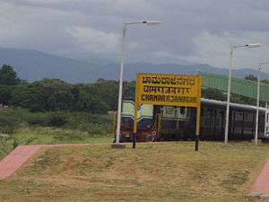
Chamarajanagar railway station is the southern most rail point in Karnataka. There is a direct train to Tirupati which starts by three in the afternoon and a direct train to Bengaluru in the morning. The nearest airport is Mysore airport and the nearest international airports are in Bengaluru and Coimbatore.
Religious Scenario
Maaravva or Maaramma is most widely worshiped deity in the town, more than ten temples of Maaravva can be found in the town. Chamarajeshwara Temple and Haralu Kote Anjaneya Temple are the biggest & the oldest temples respectively. Apart from these the town has many temples. As far as other religious beliefs are concerned, the town has more than 15 Mosques ; 5 Churches ; 2 Jain Basadis & 2 Buddha Viharas.
Bandit Veerappan
Since much of the southern area of the district is dense forest, it provided good refuge to the notorious bandit Veerappan, responsible for the death of over a hundred policemen. He was shot dead in an encounter with the specially formed Special Task Force (STF) on 18 October 2004, in Dharmapuri district, Tamil Nadu. He had been on the run for over two decades. The presence of illegal quarrying for black stone imposes a great threat to the forests in the region.
Image gallery
 Ayyappa Temple
 Fathima Mosque
 Muslim Cemetery
 Chamarajanagar Railway Station
See also
References
- "Falling Rain Genomics, Inc - Chamarajnagar". Retrieved 1 November 2008.
- "Census of India 2011". Census Commission of India. Archived from the original on 16 June 2004. Retrieved 1 November 2008.
RAMAPURA
External links
| Wikimedia Commons has media related to Chamarajanagar. |
| Wikivoyage has a travel guide for Chamarajnagar. |