Cesar River
The Cesar River (Spanish: Río Cesar) is a river in northern Colombia which is a part of the Magdalena Basin. It flows through the Cesar-Ranchería Basin and separates the Sierra Nevada de Santa Marta from the mountain ranges of the Serranía del Perijá, an extension of the Cordillera Oriental. It flows north to south, down from the Sierra Nevada de Santa Marta in the Guajira Department onto the Cesar Department and flowing into the Zapatosa Marsh where it turns to the southwest and discharges into the Magdalena River.[1] Valledupar is the only major city on its route.
| Cesar River | |
|---|---|
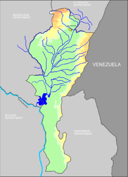 The Cesar River basin, Cesar Department in color | |
| Location | |
| Country | Colombia |
| Physical characteristics | |
| Source | |
| • location | Colombia |
| Mouth | |
• location | Magdalena River |
Tributaries
- Badillo River[2]
- Guatapuri River[2]
- Ariguani River[2]
- Villanueva River, 43 kilometres (27 mi) in length out of the Cerro Pintao.[3]
- Various streams of the Zapatosa Marshes including the
- Bartolazo wetlands;
- Pancuiche wetlands;
- Pancuichito wetlands;
- La Palma wetlands;
- Santo Domingo wetlands; and
- Tiojuancho wetlands.
References
- Index Geografia Hidrografia (Colombian Hydrographic Index) Archived November 8, 2006, at the Wayback Machine in Spanish
- Bealey, J. T. (1887) "Sierra Nevada de Santa Marta" Scottish Geographical Magazine 3: pp. 174-184, page 180
- "Municipio Villanueva - Geografia (Villanueva Municipality - Geography)" (in Spanish), accessed 8 December 2008
Further reading
- Striffler, Luis (1989) El Río César: Relación de un viaje a la Sierra Nevada de Santa Marta en 1876 Senado de la República, Bogotá, OCLC 23356826
This article is issued from Wikipedia. The text is licensed under Creative Commons - Attribution - Sharealike. Additional terms may apply for the media files.