Cerro Catedral
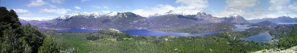
Cerro Catedral is a mountain located 19 kilometres (12 mi) from San Carlos de Bariloche, and inside the Nahuel Huapí National Park, Patagonia, Argentina.
| Cerro Catedral | |
|---|---|
 Cerro Catedral in winter | |
| Location | Rio Negro, Patagonia, Argentina |
| Nearest major city | San Carlos de Bariloche, 19 kilometres (12 mi) |
| Coordinates | 41°11′S 71°27′W |
| Top elevation | 2100 |
| Base elevation | 1030 |
| Skiable area | 600 hectares (1,500 acres) |
| Runs | 31 - 120 kilometres (75 mi) |
| Longest run | 9 km |
| Lift system | 39 |
| Lift capacity | 35,000/hour |
| Snowfall | 300 cm (median) |
| Website | Catedral |
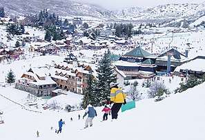
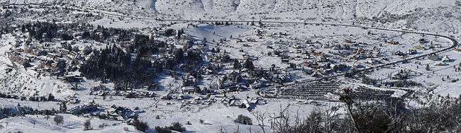
The mountain is the biggest ski center in South America and in the Southern Hemisphere, with a skiable area of 6 km2 (2.3 sq mi), 120 km (75 mi) of ski runs, and a lift capacity of 35,000 skiers per hour.[1] It is also popular due to the views of the Nahuel Huapi lake.[2] There are also a number of hotels and hostels at the foot of the mountain, and a summer hikers' hut called Refugio Lynch on one of the tops of the mountain.
During the summer, the Refugio Frey and a camping accommodate trekkers and rock climbers next to Tonček lagoon, near the Torre Principal; Catedral's highest point.
On August 27, 2005, the 1st South American Ski Mountaineering Championship in combination with the last race of the 2005 South American Ski Mountaineering Cup and the 2nd International Open of ski mountaineering was carried out on the Cerro Catedral.[3]
Climate
The climate is affected by the altitude. At higher elevations, at the weather station, the climate is classified as an alpine climate or a tundra climate (Köppen ET) while at lower elevations, the climate is classified as a cool mediterranean climate (Köppen: Csb). Cerro Catedral has the highest frequency of days with snowfalls in Argentina, averaging 98 days per year.[4]
| Climate data for Cerro Catedral, Elevation: 1,955 m. (1961-1970) | |||||||||||||
|---|---|---|---|---|---|---|---|---|---|---|---|---|---|
| Month | Jan | Feb | Mar | Apr | May | Jun | Jul | Aug | Sep | Oct | Nov | Dec | Year |
| Record high °C (°F) | 27.5 (81.5) |
25.5 (77.9) |
23.0 (73.4) |
19.4 (66.9) |
16.4 (61.5) |
13.4 (56.1) |
13.6 (56.5) |
12.3 (54.1) |
15.9 (60.6) |
21.2 (70.2) |
24.8 (76.6) |
25.6 (78.1) |
27.5 (81.5) |
| Average high °C (°F) | 12.8 (55.0) |
11.9 (53.4) |
10.6 (51.1) |
6.9 (44.4) |
3.7 (38.7) |
−0.2 (31.6) |
−0.5 (31.1) |
−0.6 (30.9) |
0.6 (33.1) |
5.2 (41.4) |
8.5 (47.3) |
11.0 (51.8) |
5.8 (42.4) |
| Daily mean °C (°F) | 7.5 (45.5) |
7.2 (45.0) |
5.7 (42.3) |
3.0 (37.4) |
0.8 (33.4) |
−2.4 (27.7) |
−2.7 (27.1) |
−2.9 (26.8) |
−2.3 (27.9) |
1.0 (33.8) |
3.7 (38.7) |
6.0 (42.8) |
2.1 (35.8) |
| Average low °C (°F) | 3.2 (37.8) |
3.0 (37.4) |
1.9 (35.4) |
−0.1 (31.8) |
−1.8 (28.8) |
−4.6 (23.7) |
−5 (23) |
−5.1 (22.8) |
−4.7 (23.5) |
−1.8 (28.8) |
0.2 (32.4) |
2.0 (35.6) |
−1.1 (30.0) |
| Record low °C (°F) | −6.8 (19.8) |
−7.0 (19.4) |
−7.6 (18.3) |
−10.7 (12.7) |
−11.7 (10.9) |
−14.0 (6.8) |
−13.9 (7.0) |
−12.9 (8.8) |
−12.4 (9.7) |
−10.2 (13.6) |
−8.6 (16.5) |
−7.6 (18.3) |
−14.0 (6.8) |
| Average precipitation mm (inches) | 59 (2.3) |
53 (2.1) |
54 (2.1) |
100 (3.9) |
196 (7.7) |
206 (8.1) |
222 (8.7) |
264 (10.4) |
104 (4.1) |
79 (3.1) |
52 (2.0) |
78 (3.1) |
1,467 (57.8) |
| Average precipitation days | 7 | 8 | 8 | 10 | 16 | 15 | 15 | 16 | 9 | 7 | 8 | 7 | 126 |
| Average snowy days | 3 | 3 | 4 | 6 | 11 | 14 | 15 | 15 | 11 | 7 | 5 | 4 | 98 |
| Average relative humidity (%) | 67.5 | 65.0 | 69.0 | 77.5 | 80.0 | 85.0 | 83.5 | 84.5 | 80.5 | 75.5 | 69.5 | 70.0 | 75.6 |
| Mean monthly sunshine hours | 294.5 | 254.3 | 229.4 | 171.0 | 130.2 | 90.0 | 86.8 | 102.3 | 156.0 | 217.0 | 237.0 | 291.4 | 2,259.9 |
| Percent possible sunshine | 65 | 65 | 59 | 52 | 41 | 32 | 28 | 32 | 43 | 53 | 55 | 62 | 49 |
| Source 1: Servico Meteorológico National,[5] UNLP (snowfall data)[6] | |||||||||||||
| Source 2: Secretaria de Mineria (extremes and sun, 1961–1970 and 1981–1990)[7] | |||||||||||||
Gallery
- Cerro Catedral in winter
 Ski lift and Refugio Lynch on the top of the Cerro Catedral
 Ski resort during the summer
 Cerro Catedral Ski resort
 Cerro Catedral Ski resort Refugio Lynch
Panoramas

References
- "Información de Pistas". Catedral Alta Patagonia. Archived from the original on 2015-07-09. Retrieved 2015-07-07.
- Global, Mansion. "Argentina's Cerro Catedral Offers a Truly Unique Ski Resort Experience". www.mansionglobal.com. Retrieved 2020-01-16.
- Declaración N° 1126-CM-05 (in Spanish), Municipal Council of Bariloche, August 9, 2005.
- "Datos extremos en el país y en el mundo" (in Spanish). Servicio Meteorológico Nacional. Retrieved June 19, 2015.
- Datos Estadísticos (Período 1961-1970), Servico Meteorológico National, Accessed 23 August 2012
- "Datos bioclimáticos de 173 localidades argentinas". Atlas Bioclimáticos (in Spanish). Universidad Nacional de La Plata. Retrieved October 13, 2015.
- "Provincia de Rio Negro - Clima Y Meteorologia: Datos Meteorologicos Y Pluviometicos" (in Spanish). Secretaria de Mineria de la Nacion (Argentina). Archived from the original on January 19, 2015. Retrieved December 17, 2013.
External links
- Catedral Alta Patagonia
- Image of Catedral mountain in winter (1000x644 pixels)
- Panoramic view of higher ski areas in winter (2400x626 pixels)
- Panoramic view from cerro the Catedral sky resort to the Andes in winter (2600x846 pixels)
- Pataclimb.com, an online climbing guidebook to Cerro Catedral
- Ski runs homologated by the FIS for alpine racing