Cerovica (Istria)
Cerovica as it was during the Venice Republic and the Austria-Hungary occupation. It was one of the 12 subdivisions as Commune or Parish in the District of Albona.[1]
Cerovica (Istria) | |
|---|---|
Municipality under Venice Republic (1420–1797), France Empire, and Austria-Hungary Empire (1867–1918) | |
 | |
| Coordinates: 45°00′N 14°09′E | |
| Country | Croatia |
| County | Istria |
| Municipality | Cerovica (Istria) |
History
From antique times, Albona / Labin, and Fianona / Plomin were two Castles and were considered one District. In 1632 the Administrator of Dalmatia and Albania, Antonio Civran, divided the territory of Albona, L'Albonese / Croatian: Labinština into 12 fractions. The names of these fractions were, Albona/Labin, Rippenda, S.Domenica/S.Nedeglia, Dubrova, Chermenizza, Vlahovo/Vlakovo, Cerovizza/Cerovica, Vettua, Cere, Cugn, Bergod, Fianona,[2] During the Austrian redivision in 1814-1818 there made two Agricultural municipalities. One was Fianona/Plomin, which consisted of Cerre, Cugn, S.Domenica/S.Nedeglia, Dubrova, Ripenda, Vettua. The other was Albona/Labin, with the fractions of Chermenizza, Bergod, Vlahovo, Cerovizza.
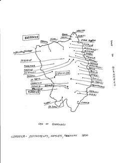
Cerovica in the 1800
Cerovica was one of twelve Municipalities or Townships in the Labinština peninsula in Istria County, Croatia, during the Austria-Hungary Empire. Cerovica is also the name of a small hamlet north of Skitača in the former municipality of Cerovica (Istria). Also called "St.Lucia di Albona", Skitača.[3] The Municipality of Cerovica (Istria) is located in the southern part of the District of Albona, (Istrian Circle) in the most southern township of the Labinstina peninsula. It is made up of eight various hills some of which are cultivable land. Most of the land was stony and very tough for the settlers when they clear it. The settlers lived in small group of houses called hamlets Croatian: selo or Italian: villa. Cerovica (Istria) borders with the Adriatic Sea at the east and south coast. On the north is the municipality of Chermanizza (Istria). On the south west is the municipality of Vlahovo (Istria). There were no roads until the 1930-40 in the municipality of Cerovica (Istria). Only small paths (called Croatian: stasica which people and animals used to go to various places. The Cement factory in Koromačno built the road in the 1930-40 which is used today to go to Labin and other cities. In 1820 there were 405 people living in municipality of Cerovica (Istria). The people owned 107 oxen, 69 cows, 1,098 sheep.In 1800 there were 86 houses most of which were made of dry stone walls and straw roofs.Mani hamlets grew tremendously during the Austrian occupation. Some owners owned more than one house and some as many as four.
Hamlets in Cerovica in the 1800
During the Austria-Hungary occupation and re-organisation the settlements which belonged to Cerovica with Skitača as the "sotto comune".
| Brovigne | Centina | Pribili |
| Banni | Squaranska | Fragnoli |
| Stara Polatsa | Schitazza | Raqvne |
| Buruti | S.Johan | Prodoll |
| Vlacichone-Gerbat | Callioni | Ceroviza |
| Mikalinka | Cecuti | Principi |
| Millivoja | Polesidi | Tomicici |
| Dregne | Gerlatz | Curato |
| Wiscowichi | Sikuli | Winograd |
| Mikulianski | Prodol | Zerjane |
| Stara Polatsa | Pillesid | Lemehi |
| Potalowi | Hudiki |
References
- "Cerovitza" (in Italian). 1824. Retrieved 21 July 2019.
- Austriaco, Lioyd (1846). "Distretto di Albona". L'Istria (in Italian). 1 (53–54): 211. Retrieved 23 December 2015.
- Archivo di Stato di Trieste. "Catasto franceschino, Elaborati del Cadasto franceschino, Distretto di Albona, Comune di S.Lucia di Albona". Ministero per i Beni e le Attivita Culturali. Retrieved 7 June 2015.
Subdivisions of Istria County | ||
|---|---|---|
| Cities and towns |  Coat of arms of Istria County | |
| Municipalities | ||