Central America Volcanic Arc
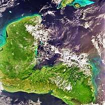
The Central American Volcanic Arc (often abbreviated to CAVA) is a chain of volcanoes which extends parallel to the Pacific coast line of the Central American Isthmus, from Guatemala, El Salvador, Honduras, Nicaragua, Costa Rica, and down to northern Panama. This volcanic arc, which has a length of 1,500 kilometres (930 mi),[1][2] is formed by an active subduction zone along the western boundary of the Caribbean Plate.

| Part of a series on |
| Central America |
|---|
 |
|
Countries |
|
Culture |
|
Economy By country
|
|
Education By country
|
|
Environment
|
|
Politics and government Elections by country
Foreign relations by country
|
|
Transportation
|
|
Related topics |
The Central American Volcanic Arc includes hundreds of volcanic formations, ranging from major stratovolcanoes, to lava domes and cinder cones. Some of these have produced large explosive eruptions, like the colossal VEI 6 eruption of the Santa Maria volcano in 1902. Central America's highest volcanoes are found in Guatemala and include the Tajumulco and Volcán Tacaná, both above 4,000 metres (13,000 ft) . Several volcanoes in Central America are currently active, including Arenal, Turrialba, Irazú, Poás, and Rincon de la Vieja in Costa Rica; Cerro Negro, San Cristóbal, Concepción in Nicaragua; Chaparrastique or San Miguel, Ilamatepec or Santa Ana, Izalco in El Salvador; Santa Maria/Santiaguito, Pacaya, Fuego in Guatemala.
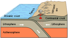 Graphical representation of a subduction zone
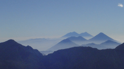 Volcanic front of the Sierra Madre
Notes
- García, 2007: 13
- Rose et al. (1999:2) mention an arc length of 1,100 km.
References
- Alvarez-Gómez, José A.; Paul T. Meijer; José J. Martinaz; Ramón Capote (2008). "Constraints from finite element modelling on the active tectonics of northern Central America and the Middle America Trench" (PDF). Tectonics. 27 (1008): TC1008. Bibcode:2008Tecto..27.1008A. doi:10.1029/2007TC002162.
- García Quintero, Janett Josefina (2007). Geometría, sismicidad y deformación de la placa de Cosos subducida (tesis) (PDF) (in Spanish). Mexico, D.F.: Centro de Geociencias, UNAM.
- Mann, Paul; Robert D. Rogers; Lisa Gahagan (2007). "Overview of plate tectonic history and its unresolved tectonic problems" (PDF). In Bundschuh, Jochen; Guillermo E. Alvarado (eds.). Central America: Geology, Resources and Hazards. Taylor & Francis. pp. 205–241. ISBN 978-0-415-41647-4.
- Melían, G.; I. Galindo; P. A. Hernández; N. M. Pérez; M. Fernández; G. Alvarado; W. Strauch; F. Barahona; D. López (2005). "Subduction process and diffuse CO2 degassing rates along Central America volcanic arc" (PDF). Geophysical Research Abstracts. 7. ISSN 1607-7962.
- Rose, W.I.; Conway, F.M.; Pullinger, C.R.; Deino, A.; McIntosh, W.C. (1999). "An improved age framework for late Quaternary silicic eruptions in northern Central America" (PDF). Bull Volcanol. 61 (1–2): 106–120. Bibcode:1999BVol...61..106R. doi:10.1007/s004450050266.
| Guatemala | 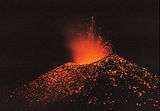 | |
|---|---|---|
| El Salvador | ||
| Nicaragua | ||
| Costa Rica |
| |
| Panama |
| |
Note: volcanoes are ordered from north-west to south-east. | ||