Caverio map
The Caverio Map (also known as Caveri Map or Canerio Map) is a map drawn by Nicolay de Caveri, circa 1506. It is kept at the Bibliothèque Nationale de France in Paris.
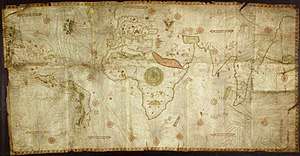
It is drawn on parchment by hand and coloured. It is composed of ten sections or panels, the whole forming a rectangle measuring 2.25 by 1.15 metres. This undated map was one of the primary sources used to make the Waldseemüller map in 1507. On the basis of this it is mostly dated to c. 1506. The map is signed with "Nicolay de Caveri Januensis". It was probably either made in Lisbon by the Genoese Canveri, or copied by him in Genoa from a Portuguese map very similar to the Cantino map, if not the Cantino map itself. The Cantino map was in Genoa toward the end of 1502 and presumably the following few years, when Caveri could have used it as the basis of his map. Or considered partly copied from the Cantino for the portions of Greenland, Newfoundland, and Brazil coast.[1]
Sanz (1961) argued that the east coast of North America is drawn with surprising accuracy, especially "when we consider the general belief that the Europeans neither saw nor set foot on the beaches in the southern states of the present-day U.S.A. before Ponce de León arrived there in 1512 or 1513, Giovanni da Verrazzano in 1523, Lucas Vásquez de Ayllón in 1520-1524 or Esteban Gómez in 1525." However, if this map is influenced by the Cantino map as stated above, this is explained by the João Fernandes Labrador and Pedro de Barcelos explorations from 1495 and 1498, and again by John Cabot in 1498 under the orders of King Manuel I of Portugal. As well as the Brazilian coastline by Portuguese explorer Pedro Álvares Cabral exploration in 1500.[2]
See also
Notes
- Gaspar, Joaquim Alves (2012). "Blunders, Errors and Entanglements: Scrutinizing the Cantino Planisphere with a Cartometric Eye". Imago Mundi. 64 (2): 181–200. doi:10.1080/03085694.2012.673762.
- Gaspar, Joaquim Alves (2012). "Blunders, Errors and Entanglements: Scrutinizing the Cantino Planisphere with a Cartometric Eye". Imago Mundi. 64 (2): 181–200. doi:10.1080/03085694.2012.673762.
References
- Carlos Sanz, Mapas antiguos del mundo, Madrid, 1961.
- Gaspar, Joaquim A. (2012) 'Blunders, Errors and Entanglements: Scrutining the Cantino planisphere with a Cartometric Eye', Imago Mundi, Vol. 64, Part 2: 181-200