Cauto River
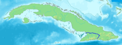
The Cauto River or Río Cauto is the longest river of Cuba. Located in southeast Cuba, it is one of two navigable rivers in Cuba, with the other being the Sagua la Grande River.
| Cauto River | |
|---|---|
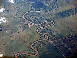 Rio Cauto near Guamo Embarcadero | |
 | |
| Location | |
| Country | Cuba |
| Physical characteristics | |
| Source | |
| ⁃ location | Sierra Maestra |
| ⁃ elevation | 600 m (1,969 ft) |
| Mouth | |
⁃ location | Gulf of Guacanayabo (Caribbean Sea) |
⁃ coordinates | 20°32′57″N 77°14′30″W |
⁃ elevation | Sea level |
| Length | 230 mi (370 km) |
| Basin size | 8,928 km2 (3,447 sq mi) |
Overview
It flows on a total length of 371 km (231 mi) from the Sierra Maestra to the west and north-west, and enters the Caribbean Sea north of Manzanillo. However, it provides only 110 km (70 mi) of transport waterway. Its water is not drinkable.
It flows through the provinces of Santiago de Cuba, Holguin, and Granma, and the communities of Palma Soriano, Cauto Cristo and Rio Cauto are located along the river. Rice, sugarcane, tobacco and cattle are raised/ grown along its course.
References
This article is issued from Wikipedia. The text is licensed under Creative Commons - Attribution - Sharealike. Additional terms may apply for the media files.