Castle Rock (Kansas)
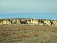
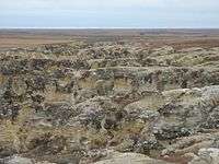
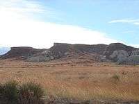
Castle Rock is a large limestone pillar landmark in Gove County, Kansas. The formation and the nearby badlands are located in the Smoky Hills region of Kansas, which is approximately 11 miles south of I-70 near Quinter, Kansas.
| Castle Rock | |
|---|---|
 Castle Rock in 2005 | |
| Highest point | |
| Elevation | 2,434 ft (742 m) [1] |
| Prominence | 70 ft (21 m) |
| Coordinates | 38°51′40″N 100°10′11″W [1] |
| Geography | |
 Castle Rock Location in U.S. | |
| Geology | |
| Age of rock | Cretaceous |
| Mountain type | Erosional remnant |
Description
Castle Rock was a landmark on the Butterfield Overland Despatch route (Overland Trail). The chalk was deposited in the area by an ancient inland sea. The formation was formed by the weathering of the chalk by wind and water. It received its name because it is said to look like a castle rising above the prairie.
Weathering of the rock formation is increasing due to visitors climbing on the rocks. In 2001, following a thunderstorm, the tallest spire fell.
On January 29, 2008, Castle Rock and Monument Rocks 31 miles to the west were jointly named as one of the 8 Wonders of Kansas.
Images
.jpg) Castle Rock, 1867
Castle Rock, 1867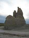 Castle Rock, 2009
See also
Further reading
- Kansas : A Cyclopedia of State History, Embracing Events, Institutions, Industries, Counties, Cities, Towns, Prominent Persons, Etc; 3 Volumes; Frank W. Blackmar; Standard Publishing Co; 944 / 955 / 824 pages; 1912. (Volume1 - Download 54MB PDF eBook),(Volume2 - Download 53MB PDF eBook), (Volume3 - Download 33MB PDF eBook)
External links
| Wikimedia Commons has media related to Castle Rock. |