Carson Sink
Carson Sink is a playa in the northeastern portion of the Carson Desert that was formerly the terminus of the Carson River. The sink is currently fed by drainage canals of the Truckee-Carson Irrigation District. The southeastern fringe of the sink where the canals enter is a wetland of the Central Basin and Range ecoregion,[1] which is mostly included within the Fallon National Wildlife Refuge and the Stillwater Wildlife Management Area. This area serves as an important stopover for migrating waterfowl. The Sehoo Formation is in the south of the Carson Sink.[2]
| Carson Sink | |
|---|---|
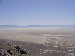 View southeast across the Carson Sink from Topog Peak in the West Humboldt Range | |
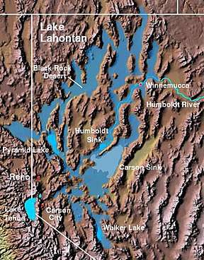 The Carson Sink and the Lahontan Valley form the central portion of the lake bed of the prehistoric Lake Lahontan. | |
| Location | Lahontan Basin, Nevada |
| Coordinates | 39°52′40″N 118°20′50″W |
| Area | 300 sq mi (780 km2) |
Carson Sink and Lone Rock working areas
The Carson Sink and Lone Rock working areas are the northwest portion of both the Carson Sink and the Fallon Range Training Complex.[3] The Lone Rock working area includes the Bravo-20 range which has numerous targets for combat aircraft training.[3] Lone Rock is in the middle of a Bravo-20 live bombing area[3] and is a solitary pinnacle of rock through the playa that is held sacred by the Paiute.[4]
History
The Carson Sink was a deep portion of the Pleistocene water body Lake Lahontan,[5] the lakebed of which is now the Lahontan Basin.
The Carson Trail used during the California Gold Rush across the Lahontan Basin included a section from through the Forty Mile Desert to the first drinkable water on the Carson River.[6] The Carson Sink station of the Pony Express was built in March, 1860.[7]
Two U.S. Air Force colonels flew a B-25 bomber from Hamilton Field near San Francisco to Colorado Springs, Colorado in June 1952. While passing over Carson Sink, the two allegedly saw three unknown aircraft fly within 800 yards of their aircraft before speeding out of sight seconds later. Upon landing, the two colonels reported the incident to the Air Defence Command headquarters who informed them that there were no military or civilian aircraft in the area at the time. The case went unsolved and is known today as the Carson Sink UFO incident.[8]
In 1984, the natural dike between the Carson Sink and the Humboldt Sink was breached by the Nevada Department of Transportation to prevent Interstate 80 and the town of Lovelock from flooding due to unusually heavy snowfall in the preceding three years. The sinks remained connected by water for 3 years, until 1987.
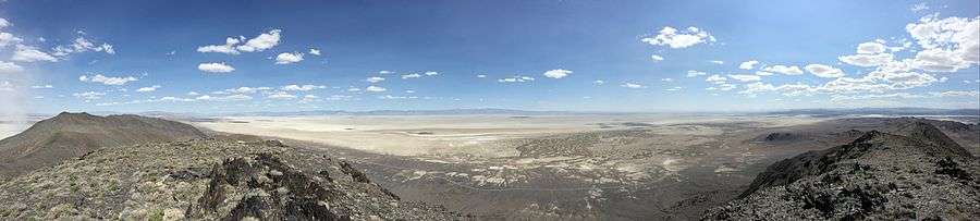
Panorama
See also
References
- Bryce, S.A; et al., Ecoregions of Nevada (PDF) (poster), Reston, Virginia: USGS, retrieved January 12, 2020
- Morrison, R. B; Fry, John C (1965). "Correlation of the Middle and Late Quaternary Successions of the Lake Lahontan, Lake Bonneville, Rocky Mountain (Wasatch Range), Southern Great Plains, and Eastern Midwest Areas" (PDF). Nevada Bureau of Mines. Archived from the original (PDF) on 2010-06-06. Retrieved 2010-11-24.
- Fallon Range Training Complex, Naval Strike and Air Warfare Center (NSAWC)
- Bengston, Ginny (2003). Norther Paiute and Western Shoshone Land Use in Northern Nevada: A Class I Ethnographic/Ethnohistoric overview (Report). Cultural Resource Series. BLM. Retrieved 2018-11-05.
- "Lake Lahontan Expedition". RangeRovers.net. Archived from the original on 2013-07-12. Retrieved 2013-07-12.
- "Carson Trail". Trails West.org. Retrieved 2013-07-12.
- "Carson Sink". Archived from the original on 2013-08-04. Retrieved 2013-07-12.
- Edward Ruppelt (1 March 2007). The Report on Unidentified Flying Objects. Echo Library. pp. 15–. ISBN 978-1-4068-4084-1. Retrieved 25 October 2011.
| Wikimedia Commons has media related to Carson Sink. |