Carrowkeel Megalithic Cemetery
The Carrowkeel tombs are an ancient passage tomb cluster in south County Sligo, Ireland. They were built in the 4th millennium BC, during the Neolithic era.[2] The tombs are on the Bricklieve Hills (An Bricshliabh, 'the speckled hills'), overlooking Lough Arrow, and are sometimes called the Bricklieve tombs.[3] They are named after the townland of Carrowkeel (An Cheathrú Chaol, 'the narrow quarter'). Nearby are the Caves of Kesh and Heapstown Cairn. The Carrowkeel monuments are protected as National Monuments and are considered one of the "big four" passage tomb cemeteries in Ireland, along with Carrowmore, Brú na Bóinne and Loughcrew.
Tuamaí na Ceathrún Caoile [1] | |
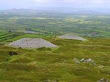 Two of the tombs at Carrowkeel. | |
 Shown within island of Ireland | |
| Location | County Sligo, Ireland |
|---|---|
| Type | passage tomb complex |
| History | |
| Founded | c. 3500 BC - 2900 BC |
| Periods | Neolithic |
National Monument of Ireland | |
| Official name | Carrowkeel Passage Tomb Cemetery |
| Reference no. | 518 |
History
The monuments at Carrowkeel were originally excavated by a team of researchers in 1911, led by R.A.S. Macalister, accompanied by Robert Lloyd Praeger and Edmund Clarence Richard Armstrong. These excavations led to an array of findings including animal bones, cremated human remains, human bones, and tools and pottery from the Neolithic Age. The particular type of crude pottery found in the Irish passage tombs is called Carrowkeel Ware, having first been recorded in the Carrowkeel Monuments. Some pottery has also been identified from the Bronze Age.
In 'The Way That I Went', Praeger gives an eerie account of the first entry into one of the Carrowkeel monuments.
"I lit three candles and stood awhile, to let my eyes accustom themselves to the dim light. There was everything, just as the last Bronze Age man (sic) had left it, three to four thousand years before. A light brownish dust covered all... There beads of stone, bone implements made from Red Deer antlers, and many fragments of much decayed pottery. On little raised recesses in the wall were flat stones, on which reposed the calcinated bones of young children."[4],
Much of the material excavated by the 1911 team was re-discovered in Cambridge, England in the early 21st Century[5] The bones are currently being researched by the Human Population Dynamics at Carrowkeel Project. The original excavation mistakenly dated the monuments as Bronze Age structures, which was later found to be incorrect after further research in the 20th Century.
Carrowkeel is set on high ground above Lough Arrow in the Bricklieve Mountains, and the tombs seem to be oriented towards the area of Cuil Irra, Knocknarea and Carrowmore. There are fourteen passage tombs in the central core of the complex at Carrowkeel; some can be entered by crawling through a narrow passage. Twelve more passage tombs are located within a radius of 6km, sometimes at elevated locations such as the Keshcorran group.
One of these outliers lies at the north end of Lough Arrow and NW Carrowkeel; the giant passage tomb, Heapstown Cairn. This is part of the legendary Moytura, a site of battles between the Tuatha Dé Danann, the ancient gods of Ireland, and the demonic Fomorians.
Tourism
Visitors to the site are asked not to climb on or damage the monuments in any way, and not to take anything in or out of the tombs. Irish folklore holds that it is bad luck to damage or disrespect such tombs and that doing so could bring a curse.[6][7] Some parts of the site contain deep crevices, holes and cliff faces.
Gallery


References
- Carrowkeel Tombs. Placenames Database of Ireland.
- Kador, Thomas; Geber, Johnny; Hensey, Robert; Meehan, Padraig; Moore, Sam. "New Dates from Carrowkeel." PAST (2015)
- Springs, Kurt (2015). "Landscape Contexts of Wedge Tombs in the Northwest of Ireland". Journal of World Anthropology, Volume 2, number 1.
- Praeger, Robert "The Way that I Went" 1937.
- Hensey, Robert; Meehan, Pádraig; Dowd, Marion; Moore, Sam. "A century of archaeology—historical excavation and modern research at the Carrowkeel passage tombs, County Sligo". (2014) Proceedings of the Royal Irish Academy Section C
- Sarah Champion & Gabriel Cooney. "Chapter 13: Naming the Places, Naming the Stones". Archaeology and Folklore. Routledge, 2005. p.193
- Doherty, Gillian. The Irish Ordnance Survey: History, Culture and Memory. Four Courts Press, 2004. p.89