Carrizozo Malpais
The Carrizozo Malpais is a large lava flow on the west side of Carrizozo, New Mexico, on the northern part of the Tularosa Basin between Sierra Blanca to the southeast and the Oscura Mountains to the west.
The lava making up the flow came from Little Black Peak, about 10 miles (16 km) north-northwest of Carrizozo. It reached about 40 miles (64 km) south-southwest along the bottom of Tularosa Basin in two active flows. Initial age estimates ranged from 1,000 to 1,500 years ago, but recent cosmogenic dating techniques revealed the eruption date is 5200 ± 700 years ago.[1] At their southern end, the lava flows are about 12 miles (19 km) north of the dune fields of White Sands National Park. The Carrizozo Woman's Club helped protect this state area.[2]
The Valley of Fires Recreation Area provides access to the Malpaís on its east edge, about 3 miles (4.8 km) west of Carrizozo on U.S. Route 380. The highway has several scenic overlooks where it crosses the Malpaís. The entire extent of the flow can be seen from higher elevations to the east on U.S. Route 380. The Trinity (nuclear test), first atomic bomb detonation site, is 20 miles (32 km) northwest.
 The location of Carrizozo.
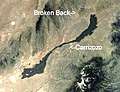
 Satellite image of Carrizozo.
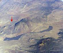
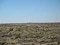 An overview of the lava flows (Little Black Peak in distance).
 A close-up view of the lava flows. Notice the pahoehoe (Hawaiian for "ropey") lava flow structure.
 A juniper tree grows out of the Carrizozo Malpaís.
See also
- Jornada del Muerto
- Jornada del Muerto Volcano
- Lava plain
References
- Landmarks: "Geochronology of the Carrizozo Malpais", New Mexico Institute of Mining and Technology; Retrieved October 8, 2014.
- Maue, Lisa (15 March 2016). "Carrizozo Woman's Club Has Deep Roots". Ruidoso News. Retrieved 13 February 2017.