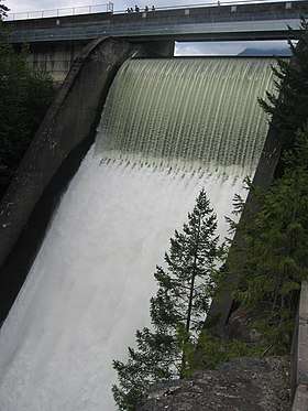
Capilano River
The Capilano River flows from north to south through the Coast Mountains on Vancouver's North Shore between West Vancouver and North Vancouver (district municipality) and empties into Burrard Inlet, opposite Stanley Park. The river is one of three primary sources of drinking water for residents of Greater Vancouver, and flows through the Capilano watershed. The Cleveland Dam, built in 1954, impounds a reservoir for this purpose. The entire reservoir and watershed area upstream of the dam is closed to the public to ensure the quality of the drinking water. Prior to construction of the Cleveland Dam, the Capilano River deposited large amounts of sediment into Burrard Inlet. A dredge was needed to remove this sediment build-up in order to keep Burrard Inlet open for ship traffic.

The Capilano has a historic salmon run which was impacted by the dam construction. In 1971 the Capilano Fish hatchery was opened. It was built 1/2 kilometre (km) downstream of the dam to ensure the survival of the run. Beyond strengthening the salmon stocks from the aftermath of the dam, the hatchery’s work also introduced chinook to the system in an attempt to establish a self-sustaining run.
The river flows through coastal rainforest and, in its lower stretches, follows a granite canyon with walls in excess of 40 metres tall in places.
The Capilano flows during periods of snow melt and rainfall mainly and slows to a trickle at other times.
The origin of the name Capilano River is obscure. The name is thought to be an anglicized form of names that were Squamish and Musqueam. The last man known as Chief Capilano died in 1870.[1]:38
Route
Capilano River's headwaters are at the top of Capilano Mountain, near Furry Creek. The river then continues down in a valley where many tributaries flow into the river like Eastcap Creek. The river then bends towards its tributary Sister's Creek which has its source at The Lions. Shortly past that confluence, the Capilano River flows into Capilano Lake, created by Cleveland Dam. When the river flows out of the dam it enters Capilano Canyon which it stays for about 4 km. After that it enters into its lowland and enters its mouth at Burrard Inlet, near Ambleside Park.

Recreation
When the river is running, whitewater kayakers in boats and apparel can often be seen. The river is rated as class III though at high water it can be much more challenging.
The Capilano River Regional Park, which surrounds the river and incorporates the fish hatchery, provides several kilometres of easy to moderate hiking trails alongside the river.
Every year in March the Capilano River is host to an annual charity duck race. Thousands of yellow rubber ducks are purchased ahead of time by the public. They float down the river in a sea of yellow. The first ducks to reach the mouth of the river win prizes for their owners.
See also
References
- Akrigg, G.P.V.; Akrigg, Helen B. (1986), British Columbia Place Names (3rd, 1997 ed.), Vancouver: UBC Press, ISBN 0-7748-0636-2
External links
| Authority control |
|
|---|