Cape Zhelaniya
Cape Zhelaniya (Russian: Мыс Желания; Mys Zhelaniya; Желание being Russian for 'wish'), is a headland in the Russian Federation. It is an important geographical landmark. The area in the vicinity of the cape is a desolate place, exposed to bitter Arctic winters. The cape along with the surrounding part of Novaya Zemlya is protected as part of Russian Arctic National Park.[1]
| Cape Zhelaniya | |
|---|---|
| Мыс Желания | |
 Location of Cape Zhelaniya | |
 | |
| Location | Arkhangelsk Oblast, |
| Coordinates | 76°57′16.08″N 68°34′54.41″E |
| Offshore water bodies | Barents Sea / Kara Sea |
| Area | Russian Far North |
Geography
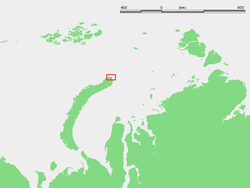
Cape Zhelaniya is located at the northern end of Severny Island, the northern island of Novaya Zemlya. This headland is a geographic point of reference to mark the separation between the northern ends of the Barents Sea and the Kara Sea.[2]
It belongs administratively to the Arkhangelsk Oblast of the Russian Federation.
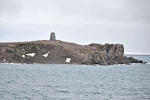 View of Cape Zhelaniya |
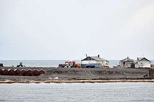 Cape Zhelaniya weather station |
History
The cape was named by Dutch explorer William Barents in 1595 as "Cape Desire" (Mys Zhelaniya in Russian).[3]
There was a Soviet Arctic station in Cape Zhelaniya in World War II which was shelled by the Kriegsmarine during Operation Wunderland.[4]
It became a secret experimental station during the Cold War while a multitude of nuclear tests, including 88 atmospheric ones, were conducted in Novaya Zemlya. It functioned as a weather station until 1994, and since 2005 there has been an automatic meteorological station located here.[5][6]
Climate
| Climate data for Cape Zhelaniya (1981-2010 normals) (Climate ID:20353) | |||||||||||||
|---|---|---|---|---|---|---|---|---|---|---|---|---|---|
| Month | Jan | Feb | Mar | Apr | May | Jun | Jul | Aug | Sep | Oct | Nov | Dec | Year |
| Record high °C (°F) | 1.1 (34.0) |
1.5 (34.7) |
3.6 (38.5) |
8.3 (46.9) |
11.1 (52.0) |
14.4 (57.9) |
19.0 (66.2) |
16.0 (60.8) |
18.7 (65.7) |
14.0 (57.2) |
5.0 (41.0) |
1.2 (34.2) |
19.0 (66.2) |
| Average high °C (°F) | −17.0 (1.4) |
−17.4 (0.7) |
−15.9 (3.4) |
−13.6 (7.5) |
−5.5 (22.1) |
0.7 (33.3) |
3.8 (38.8) |
3.8 (38.8) |
1.6 (34.9) |
−4.5 (23.9) |
−11.3 (11.7) |
−16.7 (1.9) |
−7.7 (18.2) |
| Daily mean °C (°F) | −20.7 (−5.3) |
−20.9 (−5.6) |
−19.4 (−2.9) |
−16.9 (1.6) |
−7.8 (18.0) |
−0.9 (30.4) |
2.0 (35.6) |
2.2 (36.0) |
0.1 (32.2) |
−6.5 (20.3) |
−13.9 (7.0) |
−19.6 (−3.3) |
−10.2 (13.7) |
| Average low °C (°F) | −24 (−11) |
−24.2 (−11.6) |
−22.7 (−8.9) |
−20.1 (−4.2) |
−10.0 (14.0) |
−2.5 (27.5) |
0.3 (32.5) |
0.6 (33.1) |
−1.3 (29.7) |
−8.5 (16.7) |
−16.5 (2.3) |
−22.5 (−8.5) |
−12.6 (9.3) |
| Record low °C (°F) | −40 (−40) |
−40 (−40) |
−39 (−38) |
−39 (−38) |
−31.1 (−24.0) |
−18.9 (−2.0) |
−5.4 (22.3) |
−7.2 (19.0) |
−10.6 (12.9) |
−29.5 (−21.1) |
−35 (−31) |
−39 (−38) |
−40 (−40) |
| Average precipitation mm (inches) | 9.7 (0.38) |
11.3 (0.44) |
16.0 (0.63) |
7.9 (0.31) |
17.5 (0.69) |
16.0 (0.63) |
23.3 (0.92) |
27.9 (1.10) |
25.6 (1.01) |
21.3 (0.84) |
14.2 (0.56) |
16.0 (0.63) |
206.7 (8.14) |
| Average precipitation days (≥ 1 mm) | 12.6 | 11.8 | 13.8 | 11.3 | 18.9 | 15.8 | 15.6 | 19.7 | 19.7 | 21.1 | 15.6 | 11.7 | 187.6 |
| Source 1: Météo climat stats[7] | |||||||||||||
| Source 2: Météo Climat [8] | |||||||||||||
References
- "Territories - Russian Arctic National Park". Retrieved 8 October 2017.
- "Mys Zhelaniya". Mapcarta. Retrieved 23 September 2016.
- 1967-, Zeeberg, JaapJan (2002). Climate and glacial history of the Novaya Zemlya archipelago, Russian Arctic : with notes on the region's history of exploration. Amsterdam: Rozenberg. ISBN 9051705638. OCLC 49316225.CS1 maint: numeric names: authors list (link)
- Soviet polar explorers repel Nazi naval attack
- "Climatic data". Archived from the original on 2017-08-04. Retrieved 2008-07-03.
- Weather station Archived 2006-10-03 at the Wayback Machine
- "Moyennes 1981-2010 Russie" (in French). Retrieved 1 November 2019.
- "Météo Climat stats for Mys Zhelaniya". Météo Climat. Retrieved 1 November 2019.
Literature
- F. Romanenko, O. Shilovtseva, Russian-Soviet polar stations and their role in the Arctic Seas exploration.
- History of the Northern Sea Route
- Geology