Cape Irōzaki
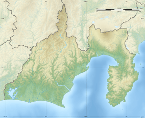
Cape Irōzaki (石廊崎, Irōzaki) is a headland on southernmost point on the Izu Peninsula on the island of Honshu in Japan. It is located within the borders of the town of Minamiizu, Shizuoka and is within the borders of the Fuji-Hakone-Izu National Park. The cape marks the border between Sagami Bay and Suruga Bay and also between the Philippine Sea and the Pacific Ocean.
| Cape Irōzaki | |
|---|---|
| 石廊崎, Irō Zaki, Cape Iro, Irō-saki | |
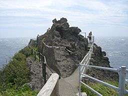 Viewpoint and shimenawa encircling rock at Cape Irōzaki | |
 Irōzaki  Cape Irōzaki (Japan) | |
| Location | Izu Peninsula, Japan |
| Coordinates | 34°36′09″N 138°50′42″E[1] |
| Surface elevation | 0 m |
Irōzaki Lighthouse stands on the cape. The cape also contains a Shinto shrine, the Imuro Jinja, which claims to have been founded in the Nara period.[2]
References
- Irozaki, United States National Geospatial-Intelligence Agency, Unique Feature Identifier (UFI) -230650, archived from the original on 2011-10-03, retrieved 2017-06-20
- "Izu travel: Cape Irozaki", japan-guide.com, retrieved 2017-06-20
External links

- Japan Travel Guide
- Japan National Travel Organization (JNTO)
This article is issued from Wikipedia. The text is licensed under Creative Commons - Attribution - Sharealike. Additional terms may apply for the media files.