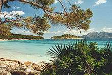
Cap de Formentor
Cap de Formentor (Catalan pronunciation: [ˈkab də fuɾmənˈto]) forms the eastern end of Majorca's Formentor peninsula. The Majorcans also call the cape the Meeting point of the winds.
Location
Cap de Formentor is located on the northernmost point of the Balearic Island Majorca in Spain. Its highest point, Fumart, is 384m above sea level. It has many associated bays, including Cala Fiquera, Cala Murta and Cala Pi de la Posada.
History
In 1863 the Formentor Lighthouse was opened, the remote and rugged location on the Cap de Formentor making construction difficult. The only access being from the sea or via a long mule track.[1]
When the poet Miquel i Llobera (1854-1922), who owned the Cap de Formentor peninsula, died, it was divided into lots and sold. In 1928 Adan Diehl, an Argentinian native and art lover, decided to build the Hotel Formentor.
The 13.5 km road which runs from Port de Pollença to Cap de Formentor was built by the Italian engineer Antonio Parietti in 1925.[2] He also constructed the snake road to Sa Calobra. Like usual for mountain roads, when the slope was too steep, the road has to go oblique, and switch direction when needed.
Attractions
The headland has a number of lookout and viewing points, including Mirador del Mal Pas, also named Mirador d'es Colomer after the small island Colomer. The panorama from Majorca's Finisterre illuminates Menorca in the east, Cala Fiquera in the west, and Alcudia with its sandy beach in the south. However, the view of the cliffs below is not for sufferers of vertigo as sea roars 300m below and the winds on the headland can be vicious.
A German radio operator and pilot built a private weather station here in 1996, which transmits encoded radio transmissions to the base station 56 km away (via a beam radio). Data is then sent all over the world wirelessly. The analyses are used by hotels, organizers, sailing clubs, flying clubs, and others. The official weather department is located in Porto Pi, on the Palma de Mallorca harbour. It is responsible for international ships, air travel and other sites.
In the southeastern part by Racó de Xot there is a cave with an opening into the sea. It has two entrances located about 8m over the surface of the water. The cave has a length of 90 m and a height of 8 m and is one of the most important sources of information for the prehistoric talaiot culture.
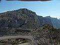 Old & New: An ancient donkeypath and the modern road
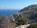 The bays of Alcúdia and Pollença as seen from the lighthouse
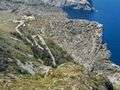 Punta de la Nao and road to the cape
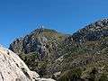 The old watchtower as seen from Punta de la Nao
References
| Wikimedia Commons has media related to Formentor. |