Callangate
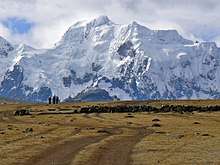
Callangate or Ccallangate is a mountain massif in the Vilcanota mountain range of the Andes in Peru.[1][2] Its highest point is Collpa Ananta[3][4][5] (possibly from Aymara and Quechua qullpa saltpeter),[6][7] also known as Chimboya, with an elevation of 6,110 metres (20,046 ft).[2][3] Another peak in the massif is called Ccallangate.[3] It lies in the Cusco Region, Quispicanchi Province, Ocongate District.[5][4] Collpa Ananta is the second highest peak in Cusco, and ranks as the 24th highest in Peru.[8]
| Callangate | |
|---|---|
 | |
| Highest point | |
| Elevation | 6,110 m (20,050 ft) |
| Coordinates | 13°43′53″S 71°09′36″W |
| Geography | |
 Callangate Peru | |
| Location | Cusco Region, Peru |
| Parent range | Andes, Vilcanota |
References
- John Biggar. "Callangate". Andes Website. Andes.org.uk. Retrieved September 7, 2016.
- "Callangate - Peakbagger.com". peakbagger.com. Retrieved 2016-09-08.
- Peru 1:100 000, Ocongate (28-t). IGN (Instituto Geográfico Nacional - Perú).
- lib.utexas.edu Map of the area showing "Collpa Ananta"
- escale.minedu.gob.pe - UGEL maps of the Quispicanchi Province 1 (Cusco Region)
- Radio San Gabriel, "Instituto Radiofonico de Promoción Aymara" (IRPA) 1993, Republicado por Instituto de las Lenguas y Literaturas Andinas-Amazónicas (ILLLA-A) 2011, Transcripción del Vocabulario de la Lengua Aymara, P. Ludovico Bertonio 1612 (Spanish-Aymara-Aymara-Spanish dictionary)
- Teofilo Laime Ajacopa, Diccionario Bilingüe Iskay simipi yuyayk'ancha, La Paz, 2007 (Quechua-Spanish dictionary)
- "Callangate - Cusco, Peru • peakery". Peakery.com. Archived from the original on 2013-10-14. Retrieved 2013-01-14.
This article is issued from Wikipedia. The text is licensed under Creative Commons - Attribution - Sharealike. Additional terms may apply for the media files.