Caburgua-Huelemolle
Caburgua-Huelemolle consists of four groups of cinder cones, namely they are Volcanes de Caburgua, Volcán Huelemolle, Volcán Redondo and Pichares. Volcanes de Caburgua is a group formed by six pyroclastic cones located at the southern tip of the Caburgua Lake, which is a lava-dammed lake created by volcanic activity from the just mentioned cones. Volcán Huelemolle is a group of three cinder cones lying between the rivers Liucura and Trancura.[1]
| Caburgua-Huelemolle | |
|---|---|
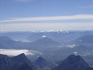 Some of the cinder cones are visible in the middle distance. The ice-capped Nevados de Sollipulli in the distance as seen from Villarrica Volcano. Also visible in the image is Caburgua Lake. | |
| Highest point | |
| Elevation | 1,496 m (4,908 ft) |
| Coordinates | 39°15′0″S 71°42′0″W |
| Geography | |
| Location | Chile |
| Parent range | Andes |
| Geology | |
| Mountain type | Cinder cones |
| Last eruption | 5050 BC ± 1000 years |
See also
This article is issued from Wikipedia. The text is licensed under Creative Commons - Attribution - Sharealike. Additional terms may apply for the media files.