Burn of Ayreland
The Burn of Ayreland (or Ireland) is a northwesterly flowing coastal stream on Mainland Orkney, Scotland, that discharges to the Clestrain Sound about two miles south of Stenness.[1] Draining chiefly agricultural lands elevated mosses and moorland. This stream has a notable lack of turbidity and a pH level of approximately 8.[2] Armouring of the stream bottom consists of pebbles, cobbles and occasional boulders.
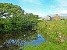
Burn of Ayreland at the Mill of Ireland (Ayreland)
Prehistory and history
This burn is located a few miles south of very significant Neolithic and Iron Age archaeological sites. A few miles to the north are the Standing Stones of Stenness and the Ring of Brodgar.[3] About three miles to the northeast is the Neolithic Maes Howe site.
See also
- Midmoss
- Waulkmill Bay
References
- United Kingdom Ordnance Survey Map Landranger 6, Orkney Mainland, 1:50,000 scale, 2003
- C.M Hogan, Natural History of the Orkney Islands, Aberdeen (2006)
- J. Gunn, Orkney, the Magnetic North, Thomas Nelson and Sons, Edinburgh (1932)
This article is issued from Wikipedia. The text is licensed under Creative Commons - Attribution - Sharealike. Additional terms may apply for the media files.