Bunda cliffs
The Bunda cliffs are part of a larger scarp of the Eucla Basin that spreads from the western part of South Australia across to the south eastern corner of Western Australia. As a geographical feature, they form part of the longest uninterrupted line of sea cliffs in the world. No other continent or country can match the cliffs for length of coastline.
The Bunda cliffs is an aboriginal name[2] which has been used in South Australia for the name of the Nullarbor coastal cliffs. The name was gazetted by the Government of South Australia on 2 October 2014 in response to a submission from the Department of Environment, Water and Natural Resources for approval to use the name for a sanctuary zone in the Far West Coast Marine Park and refers to the extent of cliff line extending from the Western Australian border to the Head of the Bight.[1][3][4][5]
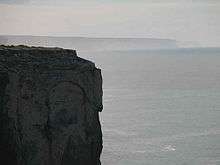
The Bunda cliffs extend for around 100 kilometres (62 mi) along the Great Australian Bight near its northern extremity and are close to the Nullarbor Plain in a very sparsely settled area of Australia.
The cliffs, which are some 60–120 metres (200–390 ft) in height, can be viewed from several viewing points along the Eyre Highway east of Eucla and west of Nullarbor roadhouse, although could be better appreciated from the air. A view of the cliffs can be had at 31°34′40″S 130°08′45″E.
Geologically the cliffs are of Tertiary age and are composed of fossiliferous limestone. The same formation can be seen from Eucla to Madura, where it forms a scarp separating the Roe Plain from the Hampton Tableland, but in this section the coastline has moved away from the cliffs. The scarp in this area runs parallel to, and within sight of, the Eyre Highway.
Baxter Cliffs
A Western Australian section of the Bunda Cliffs, the Baxter Cliffs,[6] are at a location identified by Geoscience Australia.[7] They run between Toolinna Cove[8] and Twilight Cove. They are named after a companion of the explorer Edward John Eyre, John Baxter, who was murdered there by two Aboriginals from Eyre's exploration party in April 1841.
Notes
- "Search result(s) for Bunda Cliffs (Record No. SA0068134) with the following layers being selected - "Suburbs and Localities" and "Place names (gazetteer)"". Property Location Browser. Government of South Australia. Archived from the original on 12 October 2016. Retrieved 26 April 2017.
- http://pandora.nla.gov.au/pan/60616/20060713-0000/www.wangkawilurrara.com/yalata/formations.html
- http://pandora.nla.gov.au/pan/86202/20081007-1101/www.premier.sa.gov.au/news45d3.html
- http://www.placenames.sa.gov.au Archived 17 May 2008 at the Wayback Machine bunda, according to tate, is the name given to the cliffs by the aboriginal people. located north and north-west of the great australian bight. (Rack Plan 418 / Royal Geographical Society Proceedings Vol 19 Pg 128)
- Mackay, Alice I; Shaughnessy, P. D. (Peter Douglas), (author.); Goldsworthy, S. D., (author.); South Australia. Department of Environment, Water and Natural Resources, (addressee); South Australian Aquatic Sciences Centre (issuing body) (2013), Australian sea lion abundance in the Bunda Cliffs region, GAB Marine Park, West Beach, SA SARDI Aquatic Sciences, retrieved 16 January 2018CS1 maint: multiple names: authors list (link)
- page 16 of Murray, Ian; Hercock, Marion; Murray, Ian; Hercock, Marion (2008), Where on the coast is that?, Hesperian Press, ISBN 978-0-85905-452-2
- "Archived copy". Archived from the original on 9 October 2012. Retrieved 2010-05-09.CS1 maint: archived copy as title (link) BAXTER CLIFFS -32 35 125 21
- "Toolinna Cove, Baxter Cliffs, Western Australia.(COVER PHOTOGRAPH)(Brief article)", Journal of Coastal Research, Coastal Education & Research Foundation, Inc, 29 (6), 1 November 2013, ISSN 0749-0208