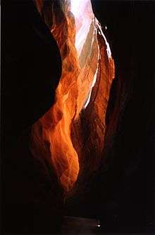
Buckskin Gulch
Buckskin Gulch (also known as Buckskin Creek, Buckskin Wash, and Kaibab Gulch) is a gulch (stream/canyon combination) in Kane County, Utah, United States,[1] that is one of the main tributaries of the Paria River (which is itself a minor tributary of the Colorado River). As it is the longest and deepest slot canyon in the southwest United States (and possibly the longest in the world)[2] [3] [4][5] it is major attraction for slot canyon hikers, receiving a high amount of foot traffic.

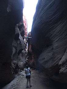
At over 13 miles (21 km) long it is often visited in conjunction with the longer Paria Canyon, although some prefer to make a long day trip out of the hike. With a distance of 20 miles (32 km), hiking this canyon in one day is possible. Wire Pass,[6] a short tributary to the Buckskin, is an alternative for a short day hike that still takes hikers through the narrow, curving features that are the hallmark of slot canyons.[7]
Access
Buckskin Gulch is reached via either U.S. Route 89 (US‑89) in Utah or U.S. Route 89A (US 89A) in Arizona and is roughly halfway between the towns of Kanab, Utah and Page, Arizona. There are four access routes to the canyon.[8]
Buckskin Trailhead
The Buckskin Trailhead is about 4.5 miles (7.2 km) south along House Rock Valley Road. The US‑89 turnoff for House Rock Valley Road is about 38 miles (61 km) east of Kanab and about 36 miles (58 km) west–northwest of Page. It can also be reached via House Rock Road (as House Rock Valley Road is known in Arizona) by heading north along the road for about 26 miles (42 km). The US 89A turnoff for House Rock Road is at House Rock in Arizona and is about 51 miles (82 km) southeast of Kanab and about 67 miles (108 km) southwest of Page. No restrooms are available at this trailhead.
Wire Pass Trailhead
The Wire Pass Trailhead accessed along the same road, but is about 8 miles (13 km) south of US‑89 or about 21 miles (34 km) north of House Rock. This entrance more popular that the other three as it provides for the quickest access to best parts of Buckskin Gulch and because it is the same trailhead used to access the Coyote Buttes, home to The Wave, a famous sandstone rock formation. (Access to The Wave requires a special, separate permit.) Restrooms are available at this trailhead.
White House Trailhead
The White House Trailhead is about 2 miles (3.2 km) south along White House Trailhead Road, which can only be accessed from US‑89. The US‑89 turnoff for White House Trailhead Road is about 43 miles (69 km) east of Kanab and about 36 miles (58 km) northwest of Page. Restrooms are available at this trailhead.
Lee's Ferry
In addition to the more direct routes to Buckskin Gulch, it can also be reached by way of Paria Canyon/Paria River. The Paria Canyon access at Lees Ferry, which can only be reached from US 89A, is about 5 miles (8.0 km) northeast along Lees Ferry Road in the Glen Canyon National Recreation Area. The US 89A turnoff for Lees Ferry Road isjust west of the Navajo Bridge and about 78 miles (126 km) east–southeast of Kanab and about 39 miles (63 km) southwest of Page. Restrooms and water are available at this trailhead.
Regulations
Permits are required by law for both day hiking and overnight backpacking in the Buckskin Gulch and Paria Canyon-Vermilion Cliffs Wilderness. Permits can be obtained from the Bureau of Land Management (BLM) office online. Only twenty overnight permits per day are allowed and group sizes are limited to ten persons. The overnight fee is $5.00 per person per day while day use permits are $6.00 per person per day. There is also a $6.00 fee per dog, per day. Due to the popularity of the canyon, permits typically sell out several months in advance. Campfires are prohibited and human waste cannot be buried and must be packed out in order to preserve the pristine condition of the area.[9][10] Buckskin Gulch lies within the Paria Canyon-Vermilion Cliffs Wilderness Area of the BLM.
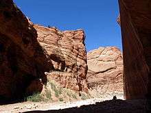
Hazards
Wire Pass and Buckskin Gulch generally do not require rappelling equipment, but there may be a few pour-offs or the necessity to wade in ankle- to chest-high water and/or mud. Hiking Buckskin Gulch is extremely challenging. Be prepared with extra clothes to wear for warmth after wading through cold, stagnant pools of water, rather than depending on campfires, which are prohibited in this confined environment. Additionally, the lack of sunlight in the canyon can make it much colder than the surrounding exposed desert. At one point along the route, there is a 15-foot (4.6 m) drop-off that usually has rope, but it is a good idea to bring at least 30 feet (9.1 m) of rope to navigate some of the pour-offs. Small areas of quicksand can also be found along the route.
Slot canyons are particularly dangerous due to the risk of flash floods. Storms more than 50 miles (80 km) away can send 100-foot-high (30 m) walls of water down the narrow canyons, and hikers have been killed in such events. Hikers should check conditions carefully and not rely on seeing the sky to judge the weather. If there is even a slight chance of rain, do not enter slot canyons.
References
- U.S. Geological Survey Geographic Names Information System: Buckskin Gulch
- "Buckskin Gulch". www.smithsonianmag.com. Smithsonian Magazine. Retrieved 10 March 2017.
- "Buckskin Gulch". utah.com. Retrieved 5 June 2020.
- "Buckskin Gulch". /www.zionnational-park.com. Retrieved 5 June 2020.
- "Buckskin Gulch". americansouthwest.net. Thde American Southwest. Retrieved 18 January 2007.
- U.S. Geological Survey Geographic Names Information System: Wire Pass
- "Buckskin Gulch". americansouthwest.net. Thde American Southwest. Retrieved 18 January 2007.
- "Buckskin Gulch Trail Guide: Backpacking the Paria River and Buckskin Gulch". wildbackpacker.com. Wild Backpacker. Retrieved June 5, 2020.
- "Paria Canyon Permit Area: Vermilion Cliffs National Monument / Paria Canyon / Vermilion Cliffs Wilderness". blm.gov. Bureau of Land Management. Retrieved June 5, 2020.
- "Paria Canyon-Vermilion Cliffs Wilderness permit information". blm.gov. July 10, 2006. Archived from the original on September 3, 2007. Retrieved June 5, 2020 – via Wayback Machine.
External links
| Wikimedia Commons has media related to Buckskin Gulch (Utah). |
- Paria Canyon-Vermillion Cliffs Wilderness
- Buckskin Gulch at climb-Utah.com, a detailed description of the hike from Wire Pass, with GPS waypoints
- Buckskin Gulch GPS map Buckskin Gulch at Wikiloc.com. See the trail on Google Maps and Google Earth.