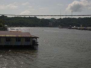
Brunei River
The Brunei River is a river which flows through Brunei[1] and empties into Brunei Bay towards the North-east direction.[2] The Istana Nurul Iman, the official residence of the Sultan of Brunei, stands on its banks. The Brunei River is the shortest major river in Brunei Darussalam. Brunei Darussalam's traditional residential areas, Kampong Ayer (Water Village), is situated on the river. Bandar Seri Begawan, the capital of Brunei Darussalam, stands on its banks. The upper reaches of the river are an important source of freshwater for the western parts of the country.
| Brunei River | |
|---|---|
 | |
| Native name | Sungai Brunei |
| Location | |
| Country | Brunei |
| Physical characteristics | |
| Source | |
| ⁃ location | confluence of Kayal and Limau Manis River |
| Mouth | |
⁃ location | at Bandar Seri Begawan into South China Sea |
⁃ elevation | 0 m (0 ft) |
| Length | 41 km (25 mi) |
| Basin size | 765 km2 (295 sq mi) |
| Basin features | |
| River system | Brunei River |
| Tributaries | |
| ⁃ left | Butir River |
| ⁃ right | Damuan River, Kedayan River, Kianggeh River |
Brunei has a long maritime history. The Sultans of Brunei once controlled all Borneo, plus parts of the Philippines and Indonesia. The region's thick jungle means the method of transport and communication was always via boats. This led to traditional settlements being established beside rivers and waterways. These waterways provided convenient transport through a jungle environment, and a supply of food.
In 2006 Brunei ministry's Department of Environment, Parks and Recreation (Jastre) initiated the clean-up campaign of the Brunei River. A total of $3.9 million has been allocated for the clean-up project, in addition to the $90,000 for the house-to-house waste collection.[3]
References
- hydrology of Brunei
- BASELINE STUDY ON CHEMICAL COMPOSITION OF BRUNEI DARUSSALAM RIVERS PDF
- Brunei River water quality 'very bad'