Breitenbach (Echaz)
The Breitenbach in baden-württembergische Landkreis Reutlingen is a southern and orographic left tributary of the Echaz, which is about 8,9 km long, southern and left tributary of the Echaz, which is located in Reutlinger. district Betzingen.
| Breitenbach | |
|---|---|
 | |
| Location | |
| Country | Germany |
| Location | Baden-Württemberg |
| Physical characteristics | |
| Mouth | |
⁃ location | Echaz |
⁃ coordinates | 48.5011°N 9.1699°E |
| Basin features | |
| Progression | Echaz→ Neckar→ Rhine→ North Sea |
Geography
Sources
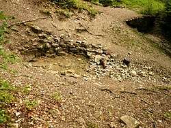
The Breitenbach has its source at Albtrauf, the northwestern steep drop of the Swabian Alb. Its main source, named Breitenbachquelle, is located about 2 km northeast of Gönningen and 750 m south of Kreisstraße 6729 and 736.5 m south of Barm on the northern flank of the Pfullinger Berg, a northern spur of the Barm 736.5, in a clearing to just over 500 meters Height. The spring, situated under a mighty slope, is enclosed in a niche of about 5 m² with natural stone and is designated as a natural monument. The water rises here at the higher layer boundary of the lower Weißjura-marl to the well-layered limestone formation [1] About 20 m below the spring, limesintercushions grow from the spring water through lime precipitation. A little further south and thus above the main spring there is another spring at a little above 600 m Height.
Course
At the beginning, the Breitenbach, which mainly flows northwards, flows through the Selchen valley and remains in the forest until it crosses the Landesstraße 383 above Reutlingen after about half of its course. Then the brook, now lined by trees and bushes, runs through agricultural land at a westerly distance from the centre of Reutlingen. After that it crosses under the Bundesstraße 28 and the railway line Plochingen-Tübingen in Reutlingen.
Estuary
The Breitenbach estuary, on its last meters flowing to the northwest, in the southern part of the Reutlingen district Betzingen at the cemetery In der Au into the Neckar inflow Echaz coming from the east-southeast.
Tributaries and still waters
To the tributaries of the Breitebach and the still waters at and near the stream belong - ordered from the source to the estuary (waters of higher order correspondingly indented under their receiving water; lengths and areas of waters according to the geodata viewer{[2]; heights in meters (m) above Normal altitude (NHN), mostly interpolated according to the contour lines there):
- Ehrensbach, from right to below 510 Height m shortly before the road from Pfullingen to Gönningen, 0.8 km; originates at below 560 m Altitude on the northern slope of the Gielsberg
- Tributary, from the left in Wolfsloch to above height|450 m Height, 1.7 km; originates at about 580 m Height at the northern foot of the Stöffelberg with ruin of Stöffel's castle ruin
- Breitwiesenbach, from right to below 440 m Height, 1.2 km; originates at over 500 m Height on the Pfingstweide in the forest west of the Pfullinger Georgenhof

- Stadtwiesenbach, from left to above 410 m Height, 1.2 km; originates at over 500 m Height at the landfill at Käpfle
- (Tributary from the Eichwald), from left to below 400 m Height at the exit into a southern corridor bay, 1,1 km; originates at about 460 m Height in the "Eichwald
- Schinderbachgraben, from the right a few steps further, 1.5 km; originates at about 510 Height in the forest a little north of the "Pfingstweide" and passes the "Teufelsklinge".
- Eichwäldlesgraben, from the left to about385 Height shortly before the L 383, 1.7 km Drains the landfill at the Hofgut Alteburg
- Schinderreingraben, from the right just after the road, 1.0 km; originates at about 430 m Height in the woods Hohlichtenrain
- Schlattwiesenbach, from the right at about 380 m Height at the northern tip of the motor sports area, 2.2 km; originates at below 545 Height in the Rötwald
- Scheuerlesbach, from the left to 363 m Height, 3.5 km; originates at below 525 m Height west of the Alteburg court estate at the edge of the forest
- (Shorter source branch), from left to below 430 m Height still before the exit of the forest, 0.9 km; originates at about 470 m Height in the forest at the Cross holm oak
- (Tributary), from the right to about 380 m Altitude in Listhof Nature Reserve, 0.7 km