Bradley Land
Bradley Land was the name Frederick Cook gave to a mass of land which he claimed to have seen between (84°20′N 102°0′W) and (85°11′N 102°0′W) during a 1909 expedition. He described it as two masses of land with a break, a strait, or an indentation between.[1] The land was named for John R. Bradley, who had sponsored Cook's expedition.

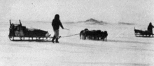
Cook published two photographs of the land and described it thus: "The lower coast resembled Heiberg Island, with mountains and high valleys. The upper coast I estimated as being about one thousand feet high, flat, and covered with a thin sheet ice."[2]
It is now known there is no land at that location and Cook's observations were based on either a misidentification of sea ice or an outright fabrication. Cook's Inuit companions reported that the photographs were actually taken near the coast of Axel Heiberg Island.[3]
See also
- Crocker Land
- Sannikov Land
References
- Balch, Edwin Swift (1913). The North Pole and Bradley Land. Philadelphia: Campion and Company. p. 54.
- Cook, Frederick A. (1911). My Attainment of the Pole: Being the Record of the Expedition that First Reached the Boreal Center, 1907–1909. New York: The Polar Publishing Co. p. 246.
- Bryce, Robert M. (2008). "Fredrick A. Cook: From Hero to Humbug". Retrieved 2009-02-23.