Bounty Islands
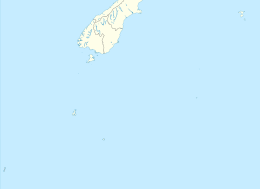
The Bounty Islands are a small group of 13 uninhabited granite islets and numerous rocks, with a combined area of 135 ha (330 acres),[1] in the South Pacific Ocean. Territorially part of New Zealand, they lie about 670 km (416 mi) east-south-east of New Zealand's South Island, 530 km (329 mi) south-west of the Chatham Islands, and 215 km (134 mi) north of the Antipodes Islands. The group is a World Heritage Site.[2]
 | |
 Bounty Islands Location relative to New Zealand's South Island | |
| Geography | |
|---|---|
| Coordinates | 47°45′S 179°03′E |
| Area | 1.35 km2 (0.52 sq mi) |
| Highest elevation | 73 m (240 ft) |
| Administration | |
| Demographics | |
| Population | 0 |
The islands are listed with the New Zealand Outlying Islands. The islands are an immediate part of New Zealand, but not part of any region or district, but instead Area Outside Territorial Authority, like all the other outlying islands except the Solander Islands.
History
Captain William Bligh discovered the Bounty Islands en route from Spithead to Tahiti in 1788, and named them after his ship HMS Bounty, just months before the famous mutiny. The location of the islands were only roughly marked on charts. In early 1866 Commander W. H. Norman of HMVS Victoria (1855) was tasked with determining more accurately their position. He reported them as being latitude 47ˈ50 South and longitude 179ˈ00 East.[3] Captain George Palmer, during the search for the Matoaka placed the islands at 47ˈ46ˈ24 South 178ˈ56ˈ45 East. Palmer also annexed the islands for New Zealand.[4]
During the 19th century the area was a popular hunting-ground for sealers.[5] The islands were also searched from time to time for missing ships and crews, including those from the General Grant and the Matoaka.[6]
The Hinemoa visited the islands in March 1886 and erected a depot for marooned sailors on the largest island. Captain Fairchild noted that there was no fresh water available on these islands.[7] The depot had been destroyed by the sea by the time the Stella visited the island in 1887.[8] A new Admiralty chart 1022 was issued for the area in 1888, which took into account survey work undertaken by the Hinemoa.
In November 1891 the Hinemoa returned to the islands and built a fresh provisions storage.[9]
Flora and fauna
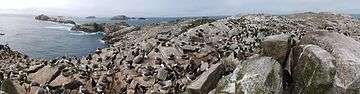
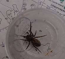
Ecologically, the islands are part of the Antipodes Subantarctic Islands tundra ecoregion. Plants include Cook's scurvy grass. The group is home to an endemic spider,[10] endemic insects, and large numbers of seabirds.
Important Bird Area
The Bounty group has been identified as an Important Bird Area (IBA) by BirdLife International because of its significance as a breeding site for erect-crested penguins, Salvin's albatrosses and Bounty shags.[11]
Geography
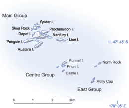
The whole chain is only 5 km (3.1 mi) across at its longest axis, and comprises three subgroups, the Main Group, the Centre Group, and the East Group. The total area is only 1.35 km2 (0.52 sq mi). The islands are at the antipodes of Bouillé-Ménard, in France (Pays de la Loire).
The Main Group is the largest of the three groups, and is located in the northwest of the chain. It includes the group's largest island, Depot Island, which is around 700 metres in length and 400 metres across at its widest point. Proclamation and Tunnel Islands are separated from Depot Island by only a narrow cleft, and are joined to it at low tide. A small islet off the north coast of this group's Spider Island is the chain's northernmost point; the westernmost point is the western tip of Penguin Island.[12]
The Centre Group is located some 1.5 to 2 kilometres to the southeast of the Main Group, and contains three main islands, arrayed in a north–south line. A smaller islet lies immediately to the west. The northernmost of the Centre Group, Funnel Island, contain's the chain's highest point, at 73 metres (240 ft) above sea level.[13] A further 1.5 kilometres to the east is the East Group, which is also arrayed roughly in a north–south line. The largest island in this group, Molly Cap, is the group's southernmost island, and contains the chain's second-highest point, 70 metres (230 ft) above sea level. This group contains two large islets and one small islet, along with several reefs and stacks, one of which is the easternmost point in the chain.[12]
Islands
- Main Group (47°45′S 179°02′E):
- Depot Island (largest in the group), named for the castaway depot on the island.
- Dog Rock
- Lion Island
- Penguin Island
- Proclamation Island
- Ranfurly Island
- Ruatara Island
- Seal Rock
- Skua Rock
- Spider Island
- Tunnel Island
- Centre Group (47°45′45″S 179°02′40″E):
- Coronet Island
- Funnel Island (main islet)
- Prion Island
- East Group (47°46′S 179°04′E):
- Con Island
- Molly Cap (main islet)
- North Rock
See also
- List of Antarctic and subantarctic islands
- List of islands of New Zealand
- List of islands
- New Zealand subantarctic islands
- Water hemisphere
- Bounty Islands nonmarine fauna
- Campbell Plateau
- Desert island
References
- "Data Table – Protected Areas – LINZ Data Service (recorded area 135 ha)". Land Information New Zealand. Retrieved 27 August 2019.
- New Zealand Sub-Antarctic Islands. UNESCO.org (27 June 2013). Retrieved 2 August 2013.
- "Shipping," Lyttelton Times, Volume XXV, Issue 1609, 9 February 1866, Page 2
- "Proclamation," Otago Daily Times, Issue 2680, 8 September 1870, Page 2
- "Bluff Harbour," Southland Times, Issue 3773, 26 July 1880, Page 2
- "The missing boats crew," Hawke's Bay Herald, Volume 12, Issue 918, 18 February 1868, Page 3
- "The SS Hinemoa's trip," Press, Volume XLIII, Issue 6397, 22 March 1886, Page 2
- "The SS Stella's Visit to the Islands," Evening Post, Volume XXXIII, Issue 71, 25 March 1887, Page 3
- "The Hinemoa's Cruise," Oamaru Mail, Volume XVI, Issue 5125, 7 November 1891, Page 3
- . 'Radio New Zealand Going on a spider hunt'. Retrieved 3 December 2016 3:00 pm
- BirdLife International. (2012). Important Bird Areas factsheet: Bounty Islands. Downloaded from "Archived copy". Archived from the original on 10 July 2007. Retrieved 17 August 2013.CS1 maint: archived copy as title (link) on 27 January 2012.
- NZMS 272/1+5 (1981) "Snares Islands and Bounty Islands", Wellington:NZ Government Department of Lands and Surveys.
- ""New Zealand offshore islands maps – BI01 Bounty Islands"". Land Information New Zealand. 2 October 2017. Retrieved 27 August 2019.
| Sovereign states |
| .svg.png) | |||||||||
|---|---|---|---|---|---|---|---|---|---|---|---|
Dependencies and other territories |
| ||||||||||