Boulevard Périphérique
Boulevard Périphérique (French pronunciation: [bulvaʁ peʁifeʁik]), sometimes called Périph', is a controlled-access dual-carriageway ring road in Paris, France. With a few exceptions (see Structure and Layout), it is situated along Paris's administrative limit.

The speed limit is 70 km/h (45 mph). Each ring generally has four traffic lanes, with no hard shoulder. At junctions, circulating traffic in the rightmost lane (separated from the other lanes at this point by a continuous white line to the left) must yield priority to entering vehicles.
When travelling at the legal speed limit, it takes around 30 minutes to complete a full circuit.
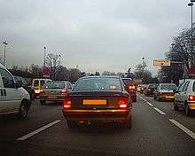
History
.jpeg)
Construction of the Périphérique began in 1958 on the former site of the Thiers Wall (the last remaining of the city walls of Paris). Destruction of this obsolete structure in the 1920s left a clear ring of vacant land surrounding Paris, which at first was claimed by slums and squatters. In order to alleviate traffic congestion, the Boulevard was planned along this land, and completed on 25 April 1973 under the presidency of Georges Pompidou. Providing a route for a quarter of all Parisian traffic movements, it quickly became the busiest road in France. It became a victim of its own success with widespread congestion, while the dense urban area surrounding it prevents its expansion.
Périphérique intérieur vs. extérieur
The Périphérique consists of two concentric carriageways: the intérieur ("inner ring") and the extérieur ("outer ring"). Vehicles travel clockwise on the inner ring and counterclockwise on the outer ring. Some stretches of the road are sometimes referred to by cardinal direction. For example, in the southern half of the highway, the "inner ring" is designated as the Périphérique Ouest ("Western Ring") as traffic flows westbound whereas the "outer ring" is designated as the Périphérique Est ("Eastern Ring") as traffic flows eastbound. In the northern half, these designations are reversed.
Structure and layout

The structure of the Boulevard Périphérique is similar to most French autoroutes, UK and Commonwealth nation motorways, and American freeways in the following regards:
- It is a two-ring, multiple-lane controlled access road with no at-grade crossings or traffic lights. Maximum longitudinal slope is 4%.
- Traffic in opposite directions is separated by a central reservation (median).
The Boulevard Périphérique also has some differences:
- Motorists entering the right-hand lane have the right-of-way, i.e. priority over vehicles already on the ring road. This stems from the traditional rules governing Parisian boulevards.
- The right-hand lane is reserved for vehicles entering or preparing to leave the "normal" movement of vehicles in the other lanes, or the Boulevard itself. A solid white line separates the recently entered traffic and the circulating traffic. This is done to prevent entering traffic from disrupting the flow of circulating traffic in the inner lanes, as without the line any traffic must yield to any entering traffic across all lanes.
- There is no hard shoulder (emergency lane), except around the Porte de Gentilly. This means that crashes can cause considerable disruption to the traffic, and makes it difficult for emergency services to reach the scene of a crash.
There are generally four lanes in each of the two rings of the Boulevard. Variations exist:
- A two-lane section between the Porte d'Italie and the Porte d'Orléans
- A five-lane section between the Porte de Montreuil and Porte de Bagnolet
- A three-lane section between the Porte d'Orléans and the Porte de Sèvres.
The full circuit of the Boulevard Périphérique measures a total of 35.04 kilometres, as measured along the central reservation. The route closely follows the municipal boundaries of Paris. It diverges in three places; in the Bois de Boulogne and the Bois de Vincennes (where the roadway is entrenched and covered), and the Heliport of Paris. Because the Boulevard was built over the old Thiers Wall, its entrance/exit ramps and interchanges coincide with the city gates, or portes in that wall. The road crosses the River Seine via bridges upstream at Charenton/Bercy and downstream at Saint-Cloud/Issy.
Small distance markers are distributed evenly alongside the roadway:
- The 00.0 kilometre point is over the River Seine, upstream of the Porte de Bercy, at the bridge's expansion joints.
- Distance from this point increases in the clockwise direction.
- The distance marks on the sign are underlined in red on the inner ring road, and in blue on the outer ring.
The roadway varies in elevation:
- 50% is elevated above its surroundings, i.e. above grade.
- 40% is constructed in trench sections, i.e. below grade.
- 10% is at ground level, i.e. at grade.
The Boulevard Périphérique can carry the heaviest vehicles allowed by French regulations. There is a height restriction of 4.75 metres (15 feet, 8 inches).
Speed control
The Boulevard Périphérique is equipped with speed cameras to enforce the 70 km/h (45 mph) speed limit. The cameras are oriented to photograph the vehicle from behind, and are reportedly installed:[1]
On the inner ring at:
- Porte de Sèvres
- Porte de Champerret
- crossing the Quai d'Ivry, at the end of the bridge
- Porte de Bagnolet
On the outer ring at:
- Porte de Châtillon
- Porte de Clichy
- Porte de Pantin
- Porte d'Auteuil
In addition, the Boulevard Périphérique's exit ramps are often monitored with hand-held binocular-type radar devices; these are triggered when the 50 km/h (31 mph) exiting limit is exceeded.
Finally, during the rush hours, radar-equipped police vehicles are stationed in hidden areas for spot checks.
Network monitoring and traffic management
About a hundred traffic cameras are installed on the boulevard and are directly connected to the control room of the Périphérique traffic management office. 166 emergency telephones are found every 500 metres along the boulevard (every 250 metres underground) which relay 7,000 calls per year. The emergency phones are all numbered, with odd numbered phones on the outer ring and even numbered phones on the inner ring road.
Eight police vehicles during the day and four at night patrol the boulevard constantly.
750 sensors embedded in the road surface record each passing vehicle. These sensors can measure the flow rate, the occupancy rate and velocity of traffic on a given portion.
Variable-message signs on the boulevard provide information on journey times, which are automatically generated every minute by a computer system using data collected by the sensors. This system provides information on the average journey time to the next major exit. These signs are also used to display general messages such as accidents, road closures, road works etc.
Other ring roads
The Boulevard Périphérique is not the only means of bypassing the interior of the French capital:
- Within the city boundaries, the Boulevards des Marechaux (Boulevards of the Marshals) encircle Paris approximately 100 m inside the Périphérique. This is a collection of urban streets with standard crossings with other streets or tunnels under some major routes of entry. The speed limit is 50 km/h.
- Beyond the city boundaries, the A86 (also known as the super-périphérique) encircles Paris at a distance of 2–7 km from the Périphérique.
- Approximately 20 km from the Périphérique, another ring road called the Francilienne is nearing completion.
- A further project, the Grand contournement de Paris, is partially constructed.
Map
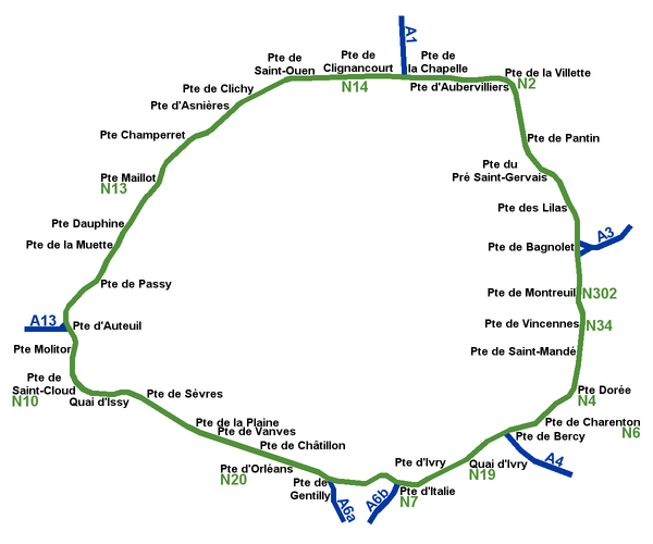
List of junctions
| Junction number | Junction name | Outer lanes exits | Inner lanes exits |
| 1 | Porte de Bercy | A4 | Quai de Bercy |
| 2 | Porte d'Ivry | None | Avenue d'Ivry |
| 3 | Porte d'Italie | A6B | Avenue d'Italie |
| 4 | Porte de Gentilly | A6A | Rue de l'Amiral Mouchez |
| 5 | Porte d'Orléans | Avenue Aristide Briand | Avenue du Maine |
| 6 | Porte de Châtillon | Avenue Pierre Brossollette | Avenue Jean Moulin |
| 7 | Porte de Vanves | Rue Ernest Renan | Boulevard Brune |
| 8 | Porte Brancion | Rue Jean Bleuzen | Avenue de la Porte-Brancion |
| 9 | Porte de la Plaine | Rue Camliant | Place des Insurges de Varsovie |
| 10 | Porte de Sèvres | None | Rue Balard |
| 11 | Porte de Saint-Cloud | Route de la Reine | Avenue de Versailles |
| 12 | Porte Molitor | Boulevard d'Auteuil | Rue Poussin |
| 13 | Porte d'Auteuil | A13 | Rue Poussin |
| 14 | Porte de Passy | Rue de l'Hippodrome | Rue de Ranelagh |
| 15 | Porte de la Muette | None | Avenue H. Martin |
| 16 | Porte Dauphine | Route de Suresnes | Avenue Foch |
| 17 | Porte Maillot | Avenue Charles De Gaulle | Avenue de la Grande Armée |
| 18 | Porte de Champerret | Boulevard Bineau | Avenue de Villiers |
| 19 | Porte d'Asnières | Rue Victor Hugo | Rue de Tocqueville |
| 20 | Porte de Clichy | Boulevard Jean Jaurès | Avenue de Clichy |
| 21 | Porte de Saint-Ouen | Avenue Gabriel Péri | Avenue de Saint-Ouen |
| 22 | Porte de Clignancourt | Avenue Michelet | Boulevard Ornano |
| 23 | Porte de la Chapelle | A1 | Rue de la Chapelle |
| 24 | Porte d'Aubervilliers | Avenue Victor Hugo | Rue d'Aubervilliers |
| 25 | Porte de la Villette | Avenue Jean Jaurès | Avenue de Flandre |
| 26 | Porte de Pantin | Avenue Jean Lolive | Avenue Jean Jaurès |
| 27 | Porte du Pré-Saint-Gervais | Rue Gabriel Péri | Rue Haxo |
| 28 | Porte des Lilas | Rue de Paris | Rue de Belleville |
| 29 | Porte de Bagnolet | A3 | Rue Belgrand |
| 30 | Porte de Montreuil | Rue de Paris | Rue d'Avron |
| 31 | Porte de Vincennes | Avenue de Paris | Cours de Vincennes |
| 32 | Porte de Saint-Mandé | Avenue Victor Hugo | Avenue de Saint-Mandé |
| 33 | Porte Dorée | Route de ceinture du Lac-Daumesnil | Avenue Daumesnil |
| 34 | Porte de Charenton | Avenue de Gravelle | Rue de Charenton |
Statistics
- Traffic in 2010:
- Total length: 35.04 km (21.77 mi)
- Average trip length: 7 km (4.3 mi)
- Speed limit: 70 km/h (43 mph)
- Average speed on working days (7 h-21 h): 43 km/h (27 mph)
See also
| Wikimedia Commons has media related to Boulevard périphérique de Paris. |
References
- "Carte des radars fixes". Archived from the original on 23 October 2010. Retrieved 30 October 2010.
- Demade 2015, p. 114.
- Demade 2015, p. 81.