Bora-Bora (commune)
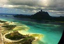
Bora-Bora is a commune of French Polynesia, an overseas territory of France in the Pacific Ocean. The commune is in the administrative subdivision of the Leeward Islands. Its population was 10,549 at the 2017 census.[1]
Bora-Bora | |
|---|---|
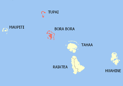 Location of the commune (in red) within the Leeward Islands | |
Location of Bora-Bora %26groups%3D_664f56457837bef2d773324b1e01cb46479c36d6.svg)
| |
| Coordinates: 16°29′40″S 151°44′11″W | |
| Country | France |
| Overseas collectivity | French Polynesia |
| Subdivision | Leeward Islands |
| Government | |
| • Mayor | Gaston Tong Sang |
| Area 1 | 41.55 km2 (16.04 sq mi) |
| Population (2017) | 10,549 |
| • Density | 250/km2 (660/sq mi) |
| Time zone | UTC−10:00 |
| INSEE/Postal code | 98714 /98730 |
| Elevation | 0–727 m (0–2,385 ft) |
| 1 French Land Register data, which excludes lakes, ponds, glaciers > 1 km2 (0.386 sq mi or 247 acres) and river estuaries. | |
The commune of Bora-Bora is made up of the island of Bora Bora proper with its surrounding islets emerging from the coral reef (30.55 km²/11.3 sq. miles in total) and of the atoll of Tupai (11 km2 (4.2 sq mi)), located 20 kilometres (12 mi) north of Bora Bora. The atoll of Tupai has no permanent population apart from some seasonal workers in the coconut plantations.
The surrounding islets include Motu Tapu, Motu Ahuna, Tevairoa, Motu Tane, Motu Mute, Motu Tufari, Motu Tehotu, Motu Pitiaau, Sofitel Motu, Motu Toopua, and Toopuaiti.
Administration
The commune is in the administrative subdivision of the Leeward Islands and consists of the following associated communes:
The administrative center of the commune is the settlement of Vaitape,[2] on the island of Bora Bora. Gaston Tong Sang is the current mayor of Bora Bora.[3]
References
- Répartition de la population en Polynésie française en 2017, Institut de la statistique de la Polynésie française
- Décret n°72-407 du 17 mai 1972 portant création de communes dans le territoire de la Polynésie française, Légifrance
- "Le maire". Bora-Bora site officiel. Retrieved 12 March 2019.