Black Fork Mohican River
The Black Fork is a principal tributary of the Mohican River, 58.4 miles (94 km) long,[3] in north-central Ohio in the United States. Via the Mohican, Walhonding, Muskingum and Ohio Rivers, it is part of the watershed of the Mississippi River, draining an area of 351 square miles (909 km²).[3] According to the Geographic Names Information System, it has also been known historically as "Armstrongs Creek" and "Black Fork Creek."[1]
| Black Fork Mohican River | |
|---|---|
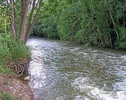 The Black Fork downstream of the dam of Charles Mill Lake in Ashland County, Ohio | |
| Location | |
| Country | United States |
| Physical characteristics | |
| Source | |
| ⁃ location | Richland County, Ohio |
| ⁃ coordinates | 40°47′18″N 82°36′20″W[1] |
| Mouth | |
⁃ location | near Loudonville, Ohio |
⁃ coordinates | 40°36′30″N 82°15′14″W[1] |
| Length | 58.4 mi (94.0 km) |
| Basin size | 351 sq mi (910 km2) |
| Discharge | |
| ⁃ location | Loudonville |
| ⁃ average | 427 cu ft/s (12.1 m3/s)[2] |

The Black Fork rises about 7 miles (11 km) west of Mansfield in Richland County, and initially flows northward through the city of Shelby, then eastward across northern Richland County before turning southeast for the remainder of its course through eastern Richland and southern Ashland Counties, past the towns of Perrysville and Loudonville. It joins the Clear Fork in Ashland County to form the Mohican River, about 2 miles (3 km) southwest of Loudonville.[4]
A U.S. Army Corps of Engineers dam in Ashland County, completed in 1936, causes the Black Fork to form Charles Mill Lake.[5]
References
- U.S. Geological Survey Geographic Names Information System: Black Fork Mohican River
- https://waterdata.usgs.gov/oh/nwis/annual/?format=sites_selection_links&search_site_no=03131500&agency_cd=USGS&referred_module=sw
- Ohio Department of Natural Resources. A Guide to Ohio Streams. Chapter 10: Major Ohio Watersheds (pdf)
- DeLorme (1991). Ohio Atlas & Gazetteer. Yarmouth, Maine: DeLorme. ISBN 978-0-89933-233-8.
- U.S. Army Corps of Engineers page for Charles Mill Lake