Bishopstone, Salisbury
Bishopstone is a village and civil parish in Wiltshire, England. It lies in the Ebble valley, about 5.5 miles (9 km) south-west of Salisbury. The parish includes the small village of Croucheston and the hamlet of The Pitts.
| Bishopstone | |
|---|---|
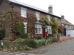 Former Post Office, Croucheston | |
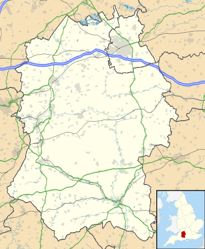 Bishopstone Location within Wiltshire | |
| Population | 684 (in 2011)[1] |
| OS grid reference | SU069257 |
| Civil parish |
|
| Unitary authority | |
| Ceremonial county | |
| Region | |
| Country | England |
| Sovereign state | United Kingdom |
| Post town | Salisbury |
| Postcode district | SP5 |
| Dialling code | 01722 |
| Police | Wiltshire |
| Fire | Dorset and Wiltshire |
| Ambulance | South Western |
| UK Parliament | |
| Website | Village |
History
The area has evidence of prehistoric settlement, such as a bowl barrow near Croucheston Down Farm.[2] Grim's Ditch, a prehistoric earthwork, forms the southern boundary of the parish.[3] A Roman road from Old Sarum to Dorchester crosses the parish.[4]
It is not known when Bishopstone was first inhabited or what it was called but fragmentary records from Saxon times indicate that the whole Chalke Valley area was thriving. It is surmised that the village was originally known as Eblesborne, but by 1166 it had been acquired by the See of Winchester and was known as Bissopeston. It is also surmised that Eblesborne meant that the land and the burna (river) was once owned by a man called Ebbel.[5]
The village of Eblesborne is mentioned by historian Michael Wood in his book Domesday, a Search for the Roots of England because in 902 the Bishop of Winchester leased an estate in 'Ebbesbourne' to Beornwulf at a rent of 45/- a year.[5] In the book Ebbesbourne Wake through the Ages Peter Meers states that this reference was about Bishopstone, not Ebbesborne Wake.[5]
The Domesday Book in 1086 divided the Chalke Valley into eight manors, Chelke (Chalke - Broad Chalke and Bowerchalke), Eblesborne (Ebbesbourne Wake), Fifehide (Fifield Bavant), Cumbe (Coombe Bissett), Humitone (Homington), Odestoche (Odstock), Stradford (Stratford Tony and Bishopstone) and Trow (circa Alvediston and Tollard Royal).[5]
The parish contains six ancient villages, possibly since Saxon times. To the north of the river these were Bishopstone, Netton and Flamston; to the south, Throope, Faulston and Croucheston. Names of former settlements survive in Netton Farmhouse (1637),[6] Throope Manor (18th century),[7] and Faulston House (17th century).[8] The roadside settlement known as The Pitts developed in the 19th century.
Religious sites
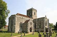
The parish church of St John the Baptist is Grade I listed.[9] Evidence survives of a 12th-century building, which was rebuilt as a cruciform church in the 13th century. The tower and two-storey porch were added in the 15th century and restoration was carried out in the 19th.[10][11] There are several monuments outside. By the south transept, a small stone cloister of two vaulted bays shelters a decorated tomb chest, perhaps that of the founder of the church. In the north transept is another richly decorated tomb recess, with stone coffin-lids, and in the south transept a mid-19th-century Gothic monument to a former rector by A. W. Pugin. At one time, above this was a window designed by Pugin and executed by William Wailes; this has since been replaced by clear glass.
A Primitive Methodist chapel was opened in 1833 at Croucheston and continued in use until 1978.[12]
Amenities
There is no school in the parish. A school was built at The Pitts in 1843 and educated children of all ages until 1932 when it became a junior school, which closed in 1977 owing to falling pupil numbers.[10][13]
Bishopstone has a village hall[14] and a pub, the White Hart. The Three Horseshoes, an inn housed in an 18th-century building,[15] closed in 2002.[16]
References
- "Bishopstone - 2011 Census". Neighbourhood Statistics. Office for National Statistics. Retrieved 20 October 2015.
- Historic England. "Croucheston Down Barn round barrow (1004772)". National Heritage List for England. Retrieved 22 October 2015.
- Historic England. "Grim's Ditch: Old Lodge Copse to Toyd Clump (1003457)". National Heritage List for England. Retrieved 22 October 2015.
- Historic England. "Knighton Roman road (1003728)". National Heritage List for England. Retrieved 22 October 2015.
- Ebbesbourne Wake through the Ages by Peter Meers
- Historic England. "Netton Old Farmhouse, Bishopstone (1318743)". National Heritage List for England. Retrieved 22 October 2015.
- Historic England. "Throope Manor, Bishopstone (1183069)". National Heritage List for England. Retrieved 22 October 2015.
- Historic England. "Faulston House, Bishopstone (1318741)". National Heritage List for England. Retrieved 22 October 2015.
- Historic England. "Church of St John the Baptist, Bishopstone (1146195)". National Heritage List for England. Retrieved 25 August 2015.
- "Victoria County History - Wiltshire - Vol 11 pp3-19 - Parishes: Bishopstone". British History Online. University of London. Retrieved 21 October 2015.
- "Church of St. John the Baptist, Bishopstone". Wiltshire Community History. Wiltshire Council. Retrieved 21 October 2015.
- "Primitive Methodist Chapel, Bishopstone". Wiltshire Community History. Wiltshire Council. Retrieved 21 October 2015.
- "Church of England School, Bishopstone". Wiltshire Community History. Wiltshire Council. Retrieved 21 October 2015.
- "Community First - Bishopstone Village Hall, Salisbury". www.communityfirst.org.uk. Archived from the original on 4 March 2016. Retrieved 21 October 2015.
- Historic England. "The Three Horseshoes (1318740)". National Heritage List for England. Retrieved 22 October 2015.
- "Bishopstone". Wiltshire Community History. Wiltshire Council. Retrieved 22 October 2015.
- The geographic coordinates are from the Ordnance Survey.
External links
![]()
| Authority control |
|
|---|