Betel (district of Paulínia)
Betel is a district of Paulínia, located 5 km to the East of Paulínia downtown, bordering the Campinas district of Barão Geraldo. Its area is about 49.5 km2 and a population of 1165 citizens. Betel is the leading example of Paulínia's growth. By 1993 the region was part of the district of Barão Geraldo in Campinas. In that year, a referendum was held on its annexation to Paulínia,[1] as Betel was economically very attached to that city. The annexation was approved by the population and the Paulínia municipality expanded in area.
History
The region of Betel began to be populated around the year 1889, when the Funilense Railroad was built. The railroad was a decisive milestone for the settlement of Barão Geraldo and Betel. Betel was then a part of Barão Geraldo. In 1950 the Alvorada Parque neighborhood was founded, slowly expanding towards the region of the Constant Pavan Avenue. As Betel grew, it approached the city of Paulínia. People had all the main obligations in Paulinia downtown. In 1993, a plebiscite was held on the annexation of Betel to Paulínia; 73.5% of 441 registered voters voted in favor of it, and Betel became a district of Paulínia.
Neighborhoods of Betel
By 1993 Betel included two neighborhoods: Alvorada Parque and Okinawa. After that year, due to the intense urban growth, new neighborhoods appeared in the district. Currently there are 18 neighborhoods in Betel, condominiums and urban centers:
- Boa Esperança
- Business Center
- Centro Empresarial nossa Senhora de Fátima
- Condomínio Santa Izabel
- Fazenda do Deserto
- Greenville
- Jardim Ivone Alegre
- Morro Azul
- Moradas de Betel
- Okinawa
- Parque das Indústrias
- Polo de Ensino Profissional
- Porto do Sol
- Residencial das Paineiras
- Residencial Manacás
- Sítio Bonomi
- Unicamp (CPQBA)
- Vila Alvorada Parque
The population is concentrated in the Alvorada Parque and the Parque das Indústrias, which is located in the main shopping district.
Urban Organization
In Betel there are three main avenues:
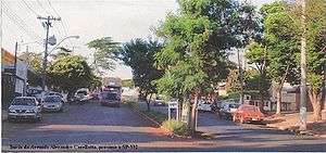
- Alexandre Cazellatto Avenue, that connects the neighborhood Alvorada Parque to neighborhoods Parque das Indústrias and the Residencial Paineiras, near the Rodovia Doutor Roberto Moreira or PLN 010.
- Constant Pavan Avenue, connecting the neighborhood Alvorada Parque to neighborhood Business Center and Nossa Senhora de Fátima, in PLN 010.
- Professor Benedito Montenegro Avenue, connecting the avenues Alexandre Cazellatto and Constant Pavan and the region of Irene Karcher Avenue, the main core of industrialization of Betel.
Besides the above avenues, there are a number of secondary roads, which are:
- Avenida Armando Botasso Street
- Avenida Irene Karcher Avenue
- Avenida Maria Estéfano Maluf Avenue
- Avenida 1 – Business Center
- Avenida 2 – Parque das Indústrias
- Estrada do Morro Azul
- PLN 393
- PLN 464
Educational Center
Betel is located in a center of vocational schools as composed of the ETEP, the SENAI, the CEFUP-Training Center of Public officials Paulínia as well as School Professor Domingos de Araújo, among others.
PLN 393 is located in the CPQBA (Center Multidisciplinary Research Chemical, Biological and Agricultural) of Unicamp, which conducts scientific and technological research.
Economy
Betel is a major industrial center, the second largest of Paulínia after the Replan region. Companies like Heringer, Galvani, Rhodia and Purina make Betel an industrialized place, but with very high levels of pollution, which makes this district a place with serious environmental problems.
References
- "estimates of the population for July 1, 2008". Paulínia News. January 16, 2009. Retrieved January 16, 2009.