Benson Hollow
Benson Hollow is a tributary of Bowman Creek in Wyoming County, Pennsylvania, in the United States. It is approximately 0.9 miles (1.4 km) long and flows through Eaton Township.[1] The watershed of the stream has an area of 1.82 square miles (4.7 km2). Benson Hollow is a first-order stream and is not designated as an impaired waterbody. The surficial geology in its vicinity consists of Wisconsinan Outwash, alluvium, Wisconsinan Till, bedrock, and a lake. The stream's watershed is designated as a High-Quality Coldwater Fishery and a Migratory Fishery.
| Benson Hollow | |
|---|---|
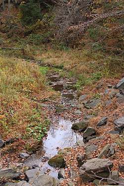 Benson Hollow looking downstream | |
| Physical characteristics | |
| Source | |
| ⁃ location | valley to the west of Cedar Ledge in Eaton Township, Wyoming County, Pennsylvania |
| ⁃ elevation | between 1,340 and 1,360 feet (408 and 415 m) |
| Mouth | |
⁃ location | Bowman Creek in Eaton Township, Wyoming County, Pennsylvania |
⁃ coordinates | 41°30′49″N 75°58′17″W |
⁃ elevation | 584 ft (178 m) |
| Length | 0.9 mi (1.4 km) |
| Basin size | 1.82 sq mi (4.7 km2) |
| Basin features | |
| Progression | Bowman Creek → Susquehanna River → Chesapeake Bay |
Course
Benson Hollow begins in a valley to the west of Cedar Ledge in Eaton Township. It flows south-southeast for a few tenths of a mile before turning east-southeast. Several tenths of a mile further downstream, the stream reaches its confluence with Bowman Creek.[1]
Benson Hollow joins Bowman Creek 1.72 miles (2.77 km) upstream of its mouth.[2]
Hydrology
Benson Hollow is not designated as an impaired waterbody.[3]
Geography and geology
The elevation near the mouth of Benson Hollow is 584 feet (178 m) above sea level.[4] The elevation of the stream's source is between 1,340 and 1,360 feet (408 and 415 m) above sea level.[1]
During the Ice Age, glacial meltwater from Benson Hollow helped form a delta in the valley of Bowman Creek. There is a "deeply notched" col at the stream's headwaters.[5]
Near the culvert, Benson Hollow has a streambed made of gravel with an average grain size of 45 millimeters (1.8 in). The stream is a Rosgen C Type stream and does not have large loads of debris.[6] The surficial geology along the lower reaches of the stream, but alluvium and a lake occur in the upper reaches. The stream's valley is flanked by Wisconsinan Till and bedrock consisting of sandstone and shale.[5]
Watershed
The watershed of Benson Hollow has an area of 1.82 square miles (4.7 km2).[2] The stream is entirely in the United States Geological Survey quadrangle of Tunkhannock.[4]
Benson Hollow is a first-order stream.[6]
A single-barrel culvert carries Benson Hollow in one reach. The culvert passes a 25-year maximum design flow. Areas of deposition occur upstream of the culvert and a large scour pool occurs downstream of it. These phenomena are typical of such culverts.[6]
History
Benson Hollow does not have a name of its own, but takes its name from the valley through which it flows.[2] The stream's valley was entered into the Geographic Names Information System on August 2, 1979. Its identifier in the Geographic Names Information System is 1169270.[4]
Biology
The drainage basin of Benson Hollow is designated as a High-Quality Coldwater Fishery and a Migratory Fishery.[7] Wild trout naturally reproduce in the stream from its headwaters downstream to its mouth.[8]
See also
- Sugar Hollow Creek, next tributary of Bowman Creek going upstream
- List of rivers of Pennsylvania
- List of tributaries of Bowman Creek
References
- United States Geological Survey, The National Map Viewer, archived from the original on April 5, 2012, retrieved September 12, 2015
- Pennsylvania Gazetteer of Streams (PDF), November 2, 2001, pp. 2, 5, retrieved September 12, 2015
- United States Environmental Protection Agency, Assessment Summary for Reporting Year 2006 Pennsylvania, Upper Susquehanna-Tunkhannock Watershed, archived from the original on November 21, 2015, retrieved September 12, 2015
- Geographic Names Information System, Feature Detail Report for: Benson Hollow, retrieved September 12, 2015
- Duane D. Braun, Surficial geology of the Tunkhannock 7.5-minute quadrangle, Wyoming County, Pennsylvania, pp. 12, 17, retrieved September 14, 2015
- Rebecca Wargo (2003), A comparison of single cell vs. multi-cell culverts, p. 15, retrieved September 13, 2015
- "§ 93.9i. Drainage List I. Susquehanna River Basin in Pennsylvania Susquehanna River", Pennsylvania Code, retrieved September 12, 2015
- Pennsylvania Fish and Boat Commission (August 2015), Pennsylvania Wild Trout Waters (Natural Reproduction) - August 2015 (PDF), p. 105, retrieved September 12, 2015