Bely Iyus
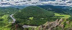
The Bely Iyus (Russian: Белый Июс – White Iyus) is a river in the republic of Khakassia in Russia. It is the right source river of the Chulym.[1] It is 224 kilometres (139 mi) long, with a drainage basin of 5,370 square kilometres (2,070 sq mi).[2]
| Bely Iyus | |
|---|---|
 | |
| Location | |
| Country | Russia |
| Physical characteristics | |
| Mouth | Chulym |
⁃ coordinates | 54.9406°N 89.8314°E |
| Length | 224 km (139 mi) |
| Basin size | 5,370 km2 (2,070 sq mi) |
| Basin features | |
| Progression | Chulym→ Ob→ Kara Sea |
The Bely Iyus has its sources on the eastern slopes of the Kuznetsky Alatau, at an elevation of 712 metres (2,336 ft). At the village of Maly Syutik it joins the Chyorny Iyus (or Black Iyus), the left source river of the Chulym. The Chulym together with the Bely Iyus is 2,023 kilometres (1,257 mi) long, and is thus one of Siberia's main rivers.
The village Iyus (Ordzhonikidzevsky District) is situated on the Bely Iyus.
References
- Чулым (река, приток Оби), Great Soviet Encyclopedia
- Река Белый Июс (Пихтерек) in the State Water Register of Russia (Russian)
- R-ArcticNET - A Regional, Electronic, Hydrographic Data Network For the Arctic Region
This article is issued from Wikipedia. The text is licensed under Creative Commons - Attribution - Sharealike. Additional terms may apply for the media files.