Belvezet
Belvezet is a former commune in the Lozère department in southern France. On 1 January 2017, it was merged into the new commune Mont Lozère et Goulet.[1]
Belvezet | |
|---|---|
Part of Mont Lozère et Goulet | |
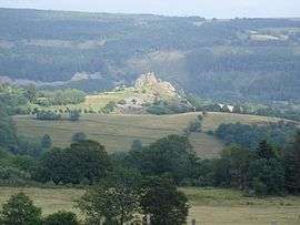 A view of the plateau of Aubrac, in Belvezet | |
.svg.png) Coat of arms | |
Location of Belvezet 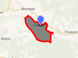
| |
 Belvezet  Belvezet | |
| Coordinates: 44°33′52″N 3°44′46″E | |
| Country | France |
| Region | Occitanie |
| Department | Lozère |
| Arrondissement | Mende |
| Canton | Grandrieu |
| Commune | Mont Lozère et Goulet |
| Area 1 | 12.39 km2 (4.78 sq mi) |
| Population (2009) | 91 |
| • Density | 7.3/km2 (19/sq mi) |
| Time zone | UTC+01:00 (CET) |
| • Summer (DST) | UTC+02:00 (CEST) |
| Postal code | 48170 |
| Elevation | 1,156–1,497 m (3,793–4,911 ft) (avg. 1,197 m or 3,927 ft) |
| 1 French Land Register data, which excludes lakes, ponds, glaciers > 1 km2 (0.386 sq mi or 247 acres) and river estuaries. | |
Geography
The commune is traversed by the river Chassezac.
Population
| Historical population | ||
|---|---|---|
| Year | Pop. | ±% |
| 1793 | 300 | — |
| 1800 | 300 | +0.0% |
| 1806 | 392 | +30.7% |
| 1821 | 452 | +15.3% |
| 1831 | 308 | −31.9% |
| 1836 | 240 | −22.1% |
| 1841 | 262 | +9.2% |
| 1846 | 222 | −15.3% |
| 1851 | 248 | +11.7% |
| 1856 | 208 | −16.1% |
| 1861 | 235 | +13.0% |
| 1866 | 208 | −11.5% |
| 1872 | 230 | +10.6% |
| 1876 | 243 | +5.7% |
| 1881 | 301 | +23.9% |
| 1886 | 302 | +0.3% |
| 1891 | 305 | +1.0% |
| 1896 | 287 | −5.9% |
| 1901 | 269 | −6.3% |
| 1906 | 259 | −3.7% |
| 1911 | 263 | +1.5% |
| 1921 | 237 | −9.9% |
| 1926 | 219 | −7.6% |
| 1931 | 225 | +2.7% |
| 1936 | 203 | −9.8% |
| 1946 | 202 | −0.5% |
| 1954 | 154 | −23.8% |
| 1962 | 133 | −13.6% |
| 1968 | 127 | −4.5% |
| 1975 | 106 | −16.5% |
| 1982 | 90 | −15.1% |
| 1990 | 79 | −12.2% |
| 1999 | 81 | +2.5% |
| 2006 | 90 | +11.1% |
| 2009 | 91 | +1.1% |
| 93 | — | |
See also
References
- Arrêté préfectoral 23 May 2016 (in French)
| Wikimedia Commons has media related to Belvezet. |
| Authority control |
|
|---|
This article is issued from Wikipedia. The text is licensed under Creative Commons - Attribution - Sharealike. Additional terms may apply for the media files.