Bedwellty
Bedwellty was a parish and urban district in Monmouthshire, South Wales, until 1974.
| Bedwellty | |
|---|---|
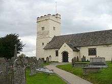 St Sannan's Church, Bedwellty | |
| Area | |
| • 1911 | 7,275 acres (29.4 km2) |
| • 1961 | 7,353 acres (29.8 km2) |
| • Coordinates | 51.6954°N 3.2072°W |
| Population | |
| • 1901 | 9,988 |
| • 1971 | 25,338 |
| History | |
| • Created | 1894 |
| • Abolished | 1974 |
| • Succeeded by | Islwyn, Rhymney Valley |
| Status | Urban district |
| • HQ | Aberbargoed |
The original ancient parish was very large,[1] including most of the upper Ebbw and Sirhowy valleys.[2] A number of coal mining communities grew up in the parish, and in the 19th century these became separate local government units.
The church of St Sannan was built in a thirteenth century Gothic style. The church tower is fourteenth century and contains six bells. The church was restored in 1858 and repaired in 1882. The exterior is whitewashed.[3]
On 19 June 1874, Ebbw Vale, Rhymney and Tredegar local boards of health and local government districts were formed, each including parts of the civil parish. The remainder of Bedwellty itself became a local government district on 29 June 1891. In 1894 the local boards were replaced by urban districts. The areas included in Bedwellty, Ebbw Vale, Rhymney and Tredegar urban districts became separate civil parishes.
Bedwellty urban district included the hamlets and villages of Aberbargoed, Argoed, Blackwood, New Tredegar, Pengam and Rock.
In 1926, Bedwellty and Mynyddislwyn urban districts formed the West Monmouthshire Omnibus Board to ensure local control of bus services. In 1935, a County Review Order altered the boundaries between Bedwellty and Mynyddislwyn.
The urban district was abolished by the Local Government Act 1972 in 1974. Its area was split: the wards of Aberbargoed, Cwmsyfiog, New Tredegar and Phillipstown passed to the Rhymney Valley district of Mid Glamorgan, and the remainder was included in the Islwyn borough of Gwent.
Further local government reorganisation in 1996 has led to the area of the former urban district being included in the county borough of Caerphilly. It now corresponds to the communities of Aberbargoed, Argoed, Bargoed, Blackwood, Cefn Fforest, New Tredegar, and part of the community of Darran Valley.
The parliamentary constituency of Bedwellty was created in 1918 covering a much larger area. It continued to exist until 1983, when it was replaced by the constituency of Islwyn. The member of parliament for the Bedwellty and Islwyn constituencies from 1970 to 1995 was Neil Kinnock, Leader of the Labour Party from 1983 to 1992, who took the title Baron Kinnock, of Bedwellty in the County of Gwent in 2005.
References
- "Monmouthshire parish map". Archived from the original on 19 December 2010. Retrieved 7 November 2010.CS1 maint: unfit url (link)
- "Bedwellte / Bedwellty". GENUKI. Retrieved 25 January 2020.
- "St Sannan's Church, Bedwellty". Coflein. Royal Commission on the Ancient and Historic Monuments of Wales. Retrieved 29 March 2017.