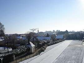
Beaufort-en-Vallée
Beaufort-en-Vallée is a former commune in the Maine-et-Loire department in western France. On 1 January 2016, it was merged into the new commune of Beaufort-en-Anjou.[2]
Beaufort-en-Vallée | |
|---|---|
Part of Beaufort-en-Anjou | |
 | |
.svg.png) Coat of arms | |
Location of Beaufort-en-Vallée 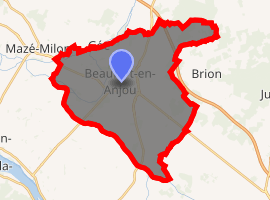
| |
 Beaufort-en-Vallée 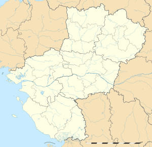 Beaufort-en-Vallée | |
| Coordinates: 47°26′25″N 0°12′51″W | |
| Country | France |
| Region | Pays de la Loire |
| Department | Maine-et-Loire |
| Arrondissement | Angers |
| Canton | Beaufort-en-Vallée |
| Commune | Beaufort-en-Anjou |
| Area 1 | 35.66 km2 (13.77 sq mi) |
| Population (2017-01-01)[1] | 6,703 |
| • Density | 190/km2 (490/sq mi) |
| Time zone | UTC+01:00 (CET) |
| • Summer (DST) | UTC+02:00 (CEST) |
| Postal code | 49250 |
| Elevation | 17–51 m (56–167 ft) (avg. 25 m or 82 ft) |
| 1 French Land Register data, which excludes lakes, ponds, glaciers > 1 km2 (0.386 sq mi or 247 acres) and river estuaries. | |
Population
| Historical population | ||
|---|---|---|
| Year | Pop. | ±% |
| 1793 | 6,214 | — |
| 1800 | 5,990 | −3.6% |
| 1806 | 5,958 | −0.5% |
| 1821 | 5,972 | +0.2% |
| 1831 | 5,914 | −1.0% |
| 1836 | 5,993 | +1.3% |
| 1841 | 5,474 | −8.7% |
| 1846 | 5,423 | −0.9% |
| 1851 | 5,207 | −4.0% |
| 1856 | 5,245 | +0.7% |
| 1861 | 5,260 | +0.3% |
| 1866 | 5,120 | −2.7% |
| 1872 | 5,146 | +0.5% |
| 1876 | 4,960 | −3.6% |
| 1881 | 4,757 | −4.1% |
| 1886 | 4,627 | −2.7% |
| 1891 | 4,492 | −2.9% |
| 1896 | 4,278 | −4.8% |
| 1901 | 4,222 | −1.3% |
| 1906 | 4,104 | −2.8% |
| 1911 | 4,038 | −1.6% |
| 1921 | 3,387 | −16.1% |
| 1926 | 3,325 | −1.8% |
| 1931 | 3,262 | −1.9% |
| 1936 | 3,171 | −2.8% |
| 1946 | 3,306 | +4.3% |
| 1954 | 3,253 | −1.6% |
| 1962 | 3,544 | +8.9% |
| 1968 | 3,623 | +2.2% |
| 1975 | 4,048 | +11.7% |
| 1982 | 4,720 | +16.6% |
| 1990 | 5,364 | +13.6% |
| 1999 | 5,384 | +0.4% |
| 2006 | 5,754 | +6.9% |
| 2009 | 6,250 | +8.6% |
References
- "Populations légales 2017". INSEE. Retrieved 6 January 2020.
- Arrêté préfectoral Archived 2016-02-15 at the Wayback Machine 18 December 2015
| Wikimedia Commons has media related to Beaufort-en-Vallée. |
| Authority control |
|
|---|
This article is issued from Wikipedia. The text is licensed under Creative Commons - Attribution - Sharealike. Additional terms may apply for the media files.