Batavia Castle
Batavia Castle (Dutch: Kasteel Batavia) was a fort located at the mouth of Ciliwung River in Jakarta. Batavia Castle was the administrative center of Dutch East India Company in Asia.[1]

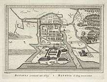
This map shows Fort Jacatra (a) and the new plan for Batavia Castle (b).

Batavia Castle in 1762 when the land-side wall had been opened toward the Kasteelplein.

From right to left: the residence of the Governor-General inside the Castle, octagonal Church at the background, and the residence of the General-Director/Councillor of VOC.

The sea-side portal of the Castle, the Waterpoort.
Batavia in 1629 showing an opening in the sea-side wall of the Castle; ornate portal has not been installed in the sea-side wall.
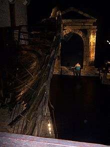
A portal salvaged from the wreck of Batavia, possibly intended to be installed for the Landpoort.

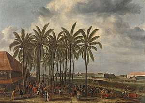
The duck pond of the Governor-General installed to the west of Batavia Castle.
Castle Batavia, the administrative center of the Dutch East India Company's Asian trade empire, which stretched from the Cape of Good Hope to Japan.
See also
| Wikimedia Commons has media related to Batavia Castle. |
- List of colonial buildings and structures in Jakarta
- List of forts in Indonesia
References
Works cited
- American Universities Field Staff (1966). Report Service: Southeast Asia series (Report). Indiana University. Retrieved November 11, 2015.CS1 maint: ref=harv (link)
- Grijns, Kees; Nas, Peter J.M., eds. (2000). Jakarta: socio-cultural essays (illustrated ed.). Leiden: KITLV Press. ISBN 9067181390.CS1 maint: ref=harv (link)
- Huystee, Marit van (1994). The Lost Gateway of Jakarta: on the Portico of the VOC Castle of Batavia in 17th century Dutch East India (PDF) (Report). Department of Maritime Archaeology. Retrieved 11 November 2015.CS1 maint: ref=harv (link)
- Ito, E.S. (2007). Rahasia Meede: Misteri Harta Karun VOC [Secret of Meede: The Mystery of VOC Treasures] (in Indonesian). Jakarta: PT Mizan Publika. ISBN 9789791140997.CS1 maint: ref=harv (link)
- "Jacatra Fort" [Jacatra Fort]. Ensiklopedi Jakarta (in Indonesian). Jakarta: Dinas Komunikasi, Informatika dan Kehumasan Pemprov DKI Jakarta. 2010. Archived from the original on 7 February 2016. Retrieved 5 November 2015.
- Kaart van het Kasteel en de Stad Batavia in het Jaar 1667 [Map of the Castle and the City Batavia in year 1667] (Map) (Den Haag ed.). 50 rhijnlandsche roeden (in Dutch). Cartography by J.J. Bollee. G.B. Hooyer and J.W. Yzerman. 1919.
- "Kasteel van Batavia" [Batavia Castle]. Ensiklopedi Jakarta (in Indonesian). Jakarta: Dinas Komunikasi, Informatika dan Kehumasan Pemprov DKI Jakarta. 2010. Archived from the original on 4 March 2016. Retrieved 5 November 2015.
- Lach, Donald F.; Kley, Edwin J. van (2000). Asia in the Making of Europe, Volume III: A Century of Advance. Book 3: Southeast Asia. Chicago: University of Chicago Press. ISBN 9780226466989.CS1 maint: ref=harv (link)
- Kratoska, Paul H., ed. (2001). South East Asia, Colonial History: Imperialism before 1800. Volume 1 of South East Asia, Colonial History (illustrated ed.). London & New York: Taylor & Francis. ISBN 9780415215404.CS1 maint: ref=harv (link)
- Restu Gunawan (2010). Gagalnya Sistem Kanal: Pengendalian Banjir Jakarta dari Masa ke Masa [The Failure of Canal System: Flood Control in Jakarta from Time to Time] (in Indonesian). Jakarta: PT Kompas Media Nusantara. ISBN 9789797094836.CS1 maint: ref=harv (link)
- van Wamelen, Carla (2010). Family life onder de VOC: Een handelscompagnie in huwelijks- en gezinszaken [Family life under the East India Company: A trading company in marital and family matters] (in Dutch). Hivlersum: Verloren. ISBN 9789087044947.CS1 maint: ref=harv (link)
This article is issued from Wikipedia. The text is licensed under Creative Commons - Attribution - Sharealike. Additional terms may apply for the media files.