Barmston, East Riding of Yorkshire
Barmston is a village in the East Riding of Yorkshire, England. It is situated on the Holderness coast, overlooking the North Sea and to the east of the A165 road. Barmston is approximately 6 miles (10 km) south of Bridlington town centre. Together with Fraisthorpe it forms the civil parish of Barmston and Fraisthorpe. Barmston is mentioned in the Domesday Book as having eight ploughlands and belonging to Drogo of la Beuvrière.[1] The name of the village derives from Beorn's Tūn (Beorn's Town).[2]
| Barmston | |
|---|---|
 Barmston Location within the East Riding of Yorkshire | |
| OS grid reference | TA163591 |
| • London | 170 mi (270 km) S |
| Civil parish | |
| Unitary authority | |
| Ceremonial county | |
| Region | |
| Country | England |
| Sovereign state | United Kingdom |
| Post town | DRIFFIELD |
| Postcode district | YO25 |
| Dialling code | 01262 |
| Police | Humberside |
| Fire | Humberside |
| Ambulance | Yorkshire |
| UK Parliament | |
The beach at Barmston was awarded the Blue flag rural beach award in 2005,[3] but was removed from the list of designated bathing beaches in 2010, as a result of erosion making access to the beach difficult.[4][5]

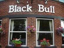
The parish church of All Saints is a Grade I listed building.[6] Barmston public house is the Black Bull. The Old Hall was designated a Grade II* listed building in 1952 and is now recorded in the National Heritage List for England, maintained by Historic England.[7]
A key industry in the village is tourism and there is a caravan park located on former agricultural land near the beach. The cliffs are made of soft marl clay and are subject to erosion. Numerous properties have been demolished over the years to prevent them from falling into the sea.[8] The position of a road leading down to the beach (long since lost to the sea) is clearly visible. The road still exists to the clifftop, which is blocked off by a barrier, and the rocks that supported the slope are still visible at low tide, giving an indication of how far the cliff has eroded. The coast road was completely lost to the sea by 1996.[9] Barmston is one of the worst locations in England for coastal erosion; in 1967, 20 feet (6 m) of coastline was lost over just two days due to storms in October.[10] The rate of erosion varies from year to year and is down to the tides and which way the winds are blowing, but typically the amount is between 4 feet (1.2 m) and 8 feet 2 inches (2.5 m) per year.[11][12]
Barmston is the proposed landfall site for a carbon capture and storage scheme linking the proposed Don Valley Power Project at Stainforth, near Hatfield in South Yorkshire and the White Rose CCS project at Drax Power Station in North Yorkshire with porous rock beneath the North Sea.[13][14][15][16]
References
- "Barmston | Domesday Book". opendomesday.org. Retrieved 29 April 2020.
- Ekwall, Eilert (1960). The concise Oxford dictionary of English place-names (4 ed.). Oxford: Oxford University Press. p. 27. ISBN 0-19-869103-3.
- "Toast to our coast". infoweb.newsbank.com. 9 November 2005. Retrieved 29 April 2020.
- "Bathing water results for England unveiled". Environment Agency. 15 November 2010. Retrieved 10 April 2015.
- "Making a splash". infoweb.newsbank.com. 14 November 2008. Retrieved 29 April 2020.
- Historic England. "Church of All Saints (1083851)". National Heritage List for England. Retrieved 13 August 2013.
- Historic England. "Old Hall (1204832)". National Heritage List for England. Retrieved 19 August 2013.
- "Owners need to demolish homes". infoweb.newsbank.com. 12 April 2004. Retrieved 29 April 2020.
- "North division: Barmston | British History Online". www.british-history.ac.uk. Retrieved 29 April 2020.
- "Holderness Coast (United Kingdom)" (PDF). copranet.projects.eucc-d.de. p. 5. Retrieved 29 April 2020.
- "Erosion's a beach". infoweb.newsbank.com. 24 April 2008. Retrieved 29 April 2020.
- "Villagers with worst coast erosion in Europe fear being swallowed by sea". infoweb.newsbank.com. 12 January 2008. Retrieved 29 April 2020.
- "Samsung backs £5bn Hatfield carbon-capture project". BBC News. BBC. 28 March 2012. Retrieved 19 June 2012.
- "New public exhibitions for Yorkshire carbon dioxide pipe". BBC News. BBC. 19 June 2012. Retrieved 19 June 2012.
- "Local residents to have their say on CCS project". National Grid. 18 June 2012. Archived from the original on 20 December 2014. Retrieved 19 June 2012.
- "Welcome to the website for the National Grid Yorkshire and Humber carbon capture, transportation and storage (CCS) project". National Grid. Retrieved 19 June 2012.
- Gazetteer — A–Z of Towns Villages and Hamlets. East Riding of Yorkshire Council. 2006. p. 3.
External links

- Historic England. "All Saint's Church (1083851)". National Heritage List for England.
- Barmston in the Domesday Book