Barmby on the Marsh
Barmby on the Marsh is a village and civil parish in the East Riding of Yorkshire, England. It is situated approximately 4 miles (6.4 km) west of the market town of Howden. It lies on the east bank of the River Ouse (and facing North Yorkshire over it), near its confluence with the River Derwent.
| Barmby on the Marsh | |
|---|---|
 Barmby on the Marsh Location within the East Riding of Yorkshire | |
| Population | 372 (2011 census)[1] |
| OS grid reference | SE688285 |
| • London | 155 mi (249 km) S |
| Civil parish |
|
| Unitary authority | |
| Ceremonial county | |
| Region | |
| Country | England |
| Sovereign state | United Kingdom |
| Post town | GOOLE |
| Postcode district | DN14 |
| Dialling code | 01757 |
| Police | Humberside |
| Fire | Humberside |
| Ambulance | Yorkshire |
| UK Parliament | |
According to the 2011 UK census, Barmby on the Marsh parish had a population of 372,[1] an increase on the 2001 UK census figure of 345.[2]
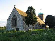
The parish church of St Helen is a Grade II listed building,[3] while the village has one pub, The Kings Head (the Sloop Inn closed some decades ago). Neighbouring Asselby also has a pub, The Black Swan.
Unusually, Barmby is situated at the end of a long dead end road, on which also lies the village of Asselby.
Barmby was served by Barmby railway station on the Hull and Barnsley Railway between 1885 and 1955.[4]
References
- UK Census (2011). "Local Area Report – Barmby on the Marsh Parish (1170211137)". Nomis. Office for National Statistics. Retrieved 14 February 2018.
- UK Census (2001). "Local Area Report – Barmby on the Marsh Parish (1543504184)". Nomis. Office for National Statistics. Retrieved 24 November 2018.
- Historic England. "Church of St Helen (1160126)". National Heritage List for England. Retrieved 29 April 2013.
- Butt, R. V. J. (1995). The Directory of Railway Stations: details every public and private passenger station, halt, platform and stopping place, past and present (1st ed.). Sparkford: Patrick Stephens Ltd. ISBN 978-1-85260-508-7. OCLC 60251199.
- Gazetteer — A–Z of Towns Villages and Hamlets. East Riding of Yorkshire Council. 2006. p. 3.
External links

- Historic England. "St Helen's Church (1160126)". National Heritage List for England.
- Barmby on the Marsh in the Domesday Book