Bariloche
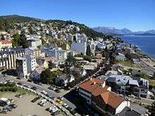
San Carlos de Bariloche, usually known as Bariloche (Spanish pronunciation: [baɾiˈlotʃe]), is a city in the province of Río Negro, Argentina, situated in the foothills of the Andes on the southern shores of Nahuel Huapi Lake. It is located within the Nahuel Huapi National Park. After development of extensive public works and Alpine-styled architecture, the city emerged in the 1930s and 1940s as a major tourism centre with skiing, trekking and mountaineering facilities. In addition, it has numerous restaurants, cafés, and chocolate shops. The city has a permanent population of 108,205 according to the 2010 census.[1] According to the latest statistics from 2015, the population is around 122,700, and a projection to 2020 dates to 135,704.[2]
San Carlos de Bariloche Bariloche | |
|---|---|
City | |
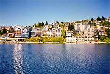
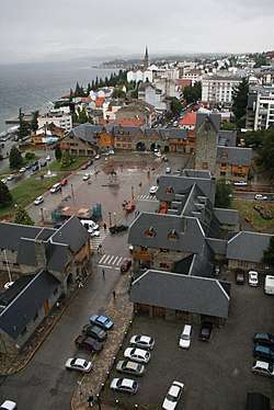 The Civic Center and port | |
 Coat of arms | |
 San Carlos de Bariloche | |
| Coordinates: 41°09′S 71°18′W | |
| Country | |
| Province | |
| Department | Bariloche |
| Established | 1902 |
| Government | |
| • Intendant | Gustavo Gennuso |
| Area | |
| • City | 220.27 km2 (85.05 sq mi) |
| Elevation | 893 m (2,930 ft) |
| Population (2010 census) | |
| • Urban | 108,205 |
| • Metro | 130,000 |
| Time zone | UTC−3 (ART) |
| Climate | Csb |
| Website | Official website |
History
The name Bariloche comes from the Mapudungun word Vuriloche meaning "people from behind the mountain" (vuri = behind, che = people). The Poya people used the Vuriloche pass to cross the Andes, keeping it secret from the Spanish priests for a long time.
There is evidence of the existence of indigenous settlements on banks of Lake Nahuel Huapi, in the area now occupied by the city of Bariloche, prior to arrival of expeditionaries and white settlers. During the Neolithic, the arrival of human beings to Nahuel Huapi region occurs. The archaeological and historical record speaks of tehuelches and puelches presence in the area. With the process of araucanization and mainly since the 17th century, the culture of these groups is strongly affected by Mapuches, who increased their presence from the settlement of Spaniards in Chile, and his continued push east.[3]
At 19th century end, in the vicinity of Nahuel Huapi, only a few scattered indigenous families were there: People of Inacayal had been stripped of their lands, and transferred to Tecka (Chubut) when the cacique was taken prisoner. Curruhinca had made an act of submission to Argentine government with his own. Some Nguillatun was still being celebrated.
But the region was beginning a new stage in its history. Although incorporated into national sovereignty, the Nahuel Huapi area began to develop fundamentally linked to Chile. Before 19th century end, when the border was still in dispute, people from the south of the neighboring country were gradually arriving to settle in surroundings of the lake. Small farmers were most of them from the island of Chiloe, but German immigrants living in Chile also arrived.[4]
Spanish explorations and missions
.jpg)
Nahuel Huapi lake was known to Spaniards since the times of the Conquest of Chile. Following the trails of the Mapuche people across the Andes, in the summer of 1552–1553, the Spanish Governor of the Captaincy of Chile Pedro de Valdivia sent Francisco de Villagra to explore the area east of the Andes at the latitudes of the city of Valdivia. Francisco de Villagra crossed the Andes through Mamuil Malal Pass and headed south until reaching Limay River in the vicinity of Nahuel Huapi Lake.[5]
Another early Spaniard to visit the zone of Nahuel Huapi Lake was the Jesuit priest Diego de Rosales. He had been ordered to the area by the Governor of Chile Antonio de Acuña Cabrera, who was concerned about the unrest of the native Puelche and Poya after the slave-hunting expeditions carried out by Luis Ponce de León in 1649, who captured Indians and sold them into slavery. Diego de Rosales started his journey at the ruins of Villarica in Chile, crossed the Andes through Mamuil Malal Pass, and traveled further south along the eastern Andean valleys, reaching Nahuel Huapi Lake in 1650.[6]
In 1670 Jesuit father Nicolás Mascardi, based in Chiloé Archipelago, entered the area through the Reloncaví Estuary and Todos los Santos Lake to found a mission at the Nahuel Huapi Lake, which lasted until 1673.[5] A new mission at the shores of Nahuel Huapi Lake was established in 1703, backed financially from Potosí, thanks to orders from the viceroy of Peru.[5] Historians disagree if the mission belonged to the jurisdiction of Valdivia or Chiloé.[5] According to historic documents, the Poya of Nahuelhuapi requested the mission to be reestablished, apparently to forge an alliance with the Spaniards against the Puelche.[5] Following the 1712 Huilliche rebellion in Chiloé Archipelago some insurgents sought refuge with Father Manuel del Hoyo in the mission.[7]
The mission was destroyed in 1717 by Poyas following a disagreement with the missionaries; the superior of the mission had refused to give them a cow.[5] Soon thereafter authorities learned that four or five people travelling to Concepción had been killed by the Poya. The colonists assembled a punitive expedition in Calbuco and Chiloé.[5] Composed of both Spaniards and indios reyunos, the expedition did not find any Poya.[5]
In 1766 the head of the Mission of Ralún tried to reestablish the mission at Nahuel Huapi, but the following year, the Crown suppressed the Society of Jesus, ordering them out of the colonies in the Americas.[5]
19th century up to 1895
The area had stronger connections to Chile than to the distant city of Buenos Aires during most of the 19th century, but the explorations of Francisco Moreno and the Argentine campaigns of the Conquest of the Desert established the legitimacy of the Argentine government. It thought the area was a natural expansion of the Viedma colony, and the Andes were the natural frontier to Chile. In the 1881 border treaty between Chile and Argentina, the Nahuel Huapi area was recognized as part of Argentina.
German settlers begun to arrive in neighboring southern Chile from the 1840s. Some of these settlers and their descendants begun a lucrative leather industry obtaining leather from indigenous communities across the Andes.[8] In the 1880s the Argentine Army displaced indigenous communities disrupting this trade and forcing leather merchants in Chile themselves to cross the Andes to obtain supplies. This way numerous entrepreneurs from Chile, many with a German background, established cattle and trade business in the area of Nahuel Huapi and Lácar lakes.[8]
Modern settlement
The modern settlement of Bariloche developed from a little shop called La Alemana (The German) established by Carlos Wiederhold in 1895. Wiederhold was a German-Chilean from a wealthy family from the city of Osorno whose ancestors arrived in the Chilean government programme of German colonization of Valdivia, Osorno and Llanquihue.[8] As Wiederhold was named consul of the German Empire in Chile he left Bariloche for Puerto Montt in the 1900s.[8] In Puerto Montt Wiederhold continued to run the business while in Bariloche Wiederhols business partner Federico Hube, also a German-Chilean from Osorno, was left in charge of local affairs.[8] By 1900 Chilean merchants dominated trade in the area of Nahuel Huapi Lake by their control of nearby mountain passes.[8] Hube & Achelis controlled Paso Pérez Rosales and Camino y Lacoste did so in Paso Puyehue.[8] A war scare between Chile and Argentina in the 1900s meant some difficulties for these earlier entrepreneurs who later came to benefit from the 1902 boundary arbitration between Chile and Argentina which increased trust along the international boundary.[8]
The Chilean entrepreneurs expanded beyond trade and established husbandry operations around Nahuel Huapi Lake. These enterprises exported meat to Central Chile and imported labour from southern Chile, mainly Chiloé Archipelago, to run the business.[8] Argentine authorities encouraged at first the immigration of Chileans offering land properties if they renounced the Chilean citizenship becoming Argentines.[8] Chilean authorities responded by offering land to those that returned from Argentina.[8] As spontaneous migration from Chiloé Archipelago begun to replace those brought in by enterprises the Argentine authorities came to distrust these migrants. Many independent settlers from Chiloé Archipelago established themselves in Valle Manso south of Bariloche.[8] In the words of historian Jorge Muñoz Sougarett, Argentine authorities viewed these Chileans settlers as "illiterate nomads, vicious and unruly".[8]
In the 1930s the centre of the city was redesigned to have the appearance of a traditional European central alpine town (it was called "Little Switzerland.") Many buildings were made of wood and stone. In 1909 there were 1,250 inhabitants; a telegraph, post office, and a road connected the city with Neuquén. Commerce continued to depend on Chile until the arrival of the railroad in 1934, which connected the city with Argentine markets.
Architectural development and tourism
.jpg)
.jpg)
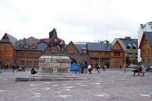
Between 1935 and 1940, the Argentine Directorate of National Parks carried out a number of urban public works, giving the city a distinctive architectural style. Among them, perhaps the best-known is the Civic Centre.
Bariloche grew from being a centre of cattle trade that relied on commerce with Chile, to becoming a tourism centre for the Argentine elite. It took on a cosmopolitan architectural and urban profile. Growth in the city's tourist trade began in the 1930s, when local hotel occupancy grew from 1550 tourists in 1934 to 4000 in 1940.[9] In 1934 Ezequiel Bustillo, then director of the National Parks Direction, contracted his brother Alejandro Bustillo to build several buildings in Iguazú and Nahuel Huapi National Park (Bariloche was the main settlement inside the park). In contrast to subtropical Iguazú National Park, planners and developers thought that Nahuel Huapi National Park, because of its temperate climate, could compete with the tourism of Europe. Together with Bariloche, it was established for priority projects by national tourism development planners.[9]
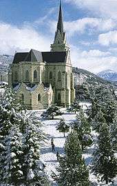
Alejandro Bustillo designed the Edificio Movilidad, Plaza Perito Moreno, the Neo-Gothic San Carlos de Bariloche Cathedral, and the Llao Llao Hotel. Architect Ernesto de Estrada designed the Civic Centre of Bariloche, which opened in 1940. The Civic Centre's tuff stone, slate and Fitzroya structures include the Domingo Sarmiento Library, the Francisco Moreno Museum of Patagonia, City Hall, the Post Office, the Police Station, and the Customs.
U.S. President Dwight Eisenhower visited Bariloche as a guest of President Arturo Frondizi in 1960. Classical violinist Alberto Lysy established the string quartet, Camerata Bariloche, here in 1967.
Huemul Project
During the 1950s, on the small island of Huemul, not far into lake Nahuel Huapi, former president Juan Domingo Perón tried to have the world's first fusion reactor built secretly. The project cost the equivalent of about $300 million modern US dollars, and it was never finished, due to the lack of the highly advanced technology that was needed. The Austrian Ronald Richter was in charge of the project. The facilities can still be visited, and are visible from certain locations on the coast.
Nazis in Bariloche
In 1995, Bariloche made headlines in the international press when it became known as a haven for Nazi war criminals, such as the former SS Hauptsturmführer Erich Priebke and SS officer Reinhard Kopps, known in Argentina as Juan Maler. Priebke had been the director of the German School of Bariloche for many years.
In his 2004 book Bariloche nazi-guía turística, Argentine author Abel Basti claims that Adolf Hitler and Eva Braun lived in the surroundings of Bariloche for many years after World War II.[10][11] Basti said that the Argentine Nazis chose the estate of Inalco as Hitler's refuge.[10]
Grey Wolf: The Escape of Adolf Hitler, a 2011 book (and subsequent film) by British authors Simon Dunstan and Gerrard Williams, proposed that Hitler and Eva Braun escaped from Berlin in 1945 and hid at Hacienda San Ramon, six miles east of Bariloche, until the early 1960s. These accounts are disputed by most historians, who generally believe that Hitler and Braun committed suicide in the last days of the Second World War.
Tourism
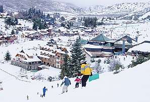
Tourism, both domestic and international, is the main economic activity of Bariloche throughout the year. The city is very popular with Brazilians, Europeans and Israelis. One of the most popular activities is skiing, and most tourists visit Bariloche in winter (June–September). Regular flights from Buenos Aires via LAN airlines and Aerolíneas Argentinas serve the city year round. The main ski slopes are the ones at Cerro Catedral, the biggest ski resort in South America and in the southern hemisphere. During the summer, beautiful beaches such as Playa Bonita and Villa Tacul welcome sun-bathers; brave lake swimmers venture into its cold waters (chilled by melting snow). Lake Nahuel Huapi averages 14 °C (57 °F) in the summertime. Bariloche is the biggest city of a huge Lakes District, and it serves as a base for many excursions in the region. Activities such as fishing, whitewater rafting, and birdwatching are popular with tourists. Trekking along trails in the nearby mountain wilderness is supported by a few high-mountain huts operated by the Club Andino Bariloche. The city is also noted for its chocolates and Swiss-style architecture. Many high school students in Argentina take a senior trip to Bariloche, and the town is well prepared to host these kinds of groups.[12] In November 2012, Bariloche was named "national capital of adventure tourism" under Law 26802 sanctioned by the Argentine National Congress.
Science

Besides tourism and related services, Bariloche is home of advanced scientific and technological activities. The Centro Atómico Bariloche is a research center of the National Atomic Energy Commission, where basic and applied research in many areas of the physical sciences is carried out. Inside it, the Instituto Balseiro, a higher education institution of the Universidad Nacional de Cuyo, with a small and carefully selected number of students, awards degrees in Physics, and in Nuclear, Mechanical and Telecommunications Engineering, and Masters and Doctorate degrees in Physics and in Engineering. The city also hosts INVAP, a high-technology company that designs and builds nuclear reactors, state-of-the-art radars and space satellites, among other projects.
The private non-profit organization Bariloche Foundation continues the tradition of scientific research in the city. Started in 1963, it promotes postgraduate teaching and research. There are also several departments and laboratories at the National University of Comahue.
Climate and geography

Bariloche lies in the transition between a cool Mediterranean climate (Köppen Csb) and an Oceanic climate (Köppen: Cfb), with marked alpine characteristics (low nighttime temperatures, wide temperature variations, high thermal amplitude). The combination of its altitude, latitude, and predominance of west-northwest winds cause the climate to be classified as a cool temperate climate with a dry season that presents a west–east precipitation gradient.[13] Mean annual precipitation ranges from 4,000 mm (157 in) in the Andean peaks and in Puerto Blest to only 600 mm (24 in) in the Limay River area.[13] In the urban areas, mean annual precipitation ranges from 800 to 1,000 mm (31 to 39 in).[13] Most of this is concentrated in autumn and winter, which are responsible for 70% of the annual precipitation.[13]
The mean annual temperature in Bariloche is 8.4 °C (47 °F) in the city centre (1901–1950).[13] At the airport in the eastern end, the mean annual temperature is 8.3 °C (47 °F) (for the period 1981–2010).[13][14] In January, daytime temperatures normally range from 20 to 28 °C (68 to 82 °F) and may occasionally go up to 30 °C (86 °F).[13] The average minimum in January is 8.2 °C (47 °F) at the city centre and 6.6 °C (44 °F) at the airport although during warm days, nighttime temperatures can reach to 15 °C (59 °F).[13][15][14] In winter, daytime temperatures range from 1 to 8 °C (34 to 46 °F) while nighttime temperatures approach freezing or less.[13] Temperatures vary by altitude; in general, the temperature decreases by 6 °C (11 °F) for every 1,000 metres (3,281 ft) increase in altitude.[13]
The weather is characterized by being windy throughout the year; 85% of the days are windy and calm days are rare.[13] Most of the wind predominantly comes from the west-northwest with easterly winds being rare.[13] Normally, the winds are strong, particularly in spring where gusts can exceed 100 km/h (62 mph).[13]
At the city centre, mean annual precipitation is 1,092 mm (43 in) in which there are 122 days with precipitation.[13] In the eastern end where the airport is located, precipitation is lower, averaging 791 mm (31 in).[13] In winter when temperatures are lower, snowfall can occur, which is favoured by the low evapotranspiration.[13] In spring, melt from snow and lower temperatures lead to moist conditions that facilitate the development of dense forest and agricultural activities.[13]
The water temperature in the lakes are always cold, ranging from 12 to 15 °C (54 to 59 °F).[13] This is due to the lakes being large, making it difficult for the sun to influence its temperature owing to their large heat capacity.[13] Smaller lakes can freeze in the winter, particularly those located in the higher elevations.[13]
| Climate data for San Carlos de Bariloche Airport (1981–2010, extremes 1951–present)[lower-alpha 1] | |||||||||||||
|---|---|---|---|---|---|---|---|---|---|---|---|---|---|
| Month | Jan | Feb | Mar | Apr | May | Jun | Jul | Aug | Sep | Oct | Nov | Dec | Year |
| Record high °C (°F) | 34.4 (93.9) |
35.4 (95.7) |
34.4 (93.9) |
26.3 (79.3) |
22.6 (72.7) |
19.4 (66.9) |
16.7 (62.1) |
19.6 (67.3) |
22.5 (72.5) |
29.1 (84.4) |
31.5 (88.7) |
33.9 (93.0) |
35.4 (95.7) |
| Average high °C (°F) | 22.6 (72.7) |
23.0 (73.4) |
19.7 (67.5) |
14.6 (58.3) |
10.2 (50.4) |
6.9 (44.4) |
6.7 (44.1) |
8.3 (46.9) |
11.5 (52.7) |
14.8 (58.6) |
17.9 (64.2) |
20.5 (68.9) |
14.7 (58.5) |
| Daily mean °C (°F) | 15.0 (59.0) |
14.8 (58.6) |
11.9 (53.4) |
7.9 (46.2) |
4.9 (40.8) |
2.9 (37.2) |
2.1 (35.8) |
3.0 (37.4) |
5.1 (41.2) |
8.0 (46.4) |
10.8 (51.4) |
13.5 (56.3) |
8.3 (46.9) |
| Average low °C (°F) | 6.6 (43.9) |
6.3 (43.3) |
4.7 (40.5) |
2.3 (36.1) |
0.6 (33.1) |
−0.6 (30.9) |
−1.6 (29.1) |
−1.1 (30.0) |
−0.2 (31.6) |
1.8 (35.2) |
3.7 (38.7) |
5.9 (42.6) |
2.4 (36.3) |
| Record low °C (°F) | −5.7 (21.7) |
−6.9 (19.6) |
−10.0 (14.0) |
−11.1 (12.0) |
−11.4 (11.5) |
−21.1 (−6.0) |
−25.4 (−13.7) |
−16.7 (1.9) |
−17.3 (0.9) |
−10.7 (12.7) |
−7.0 (19.4) |
−8.5 (16.7) |
−25.4 (−13.7) |
| Average precipitation mm (inches) | 10.0 (0.39) |
15.3 (0.60) |
35.2 (1.39) |
58.9 (2.32) |
130.1 (5.12) |
170.1 (6.70) |
122.1 (4.81) |
101.4 (3.99) |
56.5 (2.22) |
49.4 (1.94) |
29.3 (1.15) |
23.4 (0.92) |
801.7 (31.56) |
| Average snowfall cm (inches) | 0.0 (0.0) |
0.5 (0.2) |
0.0 (0.0) |
3.4 (1.3) |
7.0 (2.8) |
32.4 (12.8) |
41.7 (16.4) |
22.9 (9.0) |
6.2 (2.4) |
5.8 (2.3) |
0.2 (0.1) |
0.0 (0.0) |
120.1 (47.3) |
| Average precipitation days (≥ 0.1 mm) | 3.7 | 3.4 | 6.7 | 8.2 | 13.6 | 16.1 | 14.0 | 13.0 | 9.1 | 8.3 | 5.4 | 4.6 | 106.1 |
| Average snowy days | 0.0 | 0.1 | 0.0 | 0.5 | 1.3 | 5.1 | 5.9 | 4.4 | 2.0 | 1.6 | 0.3 | 0.1 | 21.3 |
| Average relative humidity (%) | 54.1 | 54.8 | 62.4 | 69.8 | 76.4 | 80.2 | 78.9 | 75.9 | 68.2 | 62.5 | 57.7 | 54.9 | 66.3 |
| Mean monthly sunshine hours | 347.2 | 277.2 | 251.1 | 186.0 | 136.4 | 111.0 | 117.8 | 155.0 | 192.0 | 251.1 | 309.0 | 334.8 | 2,668.6 |
| Percent possible sunshine | 75 | 72 | 65 | 56 | 45 | 39 | 40 | 47 | 54 | 61 | 71 | 72 | 58 |
| Source 1: Servicio Meteorológico Nacional (temperatures, precipitation and humidity 1981–2010, July record low, February record high)[14][16][17] | |||||||||||||
| Source 2: Instituto Nacional de Tecnología Agropecuaria (rain and snow data 1951–1990),[15] NOAA (sun 1961–1990),[18] Oficina de Riesgo Agropecuario (extremes 1991–present),[19] | |||||||||||||
| Climate data for San Carlos de Bariloche (city centre) 1901–1950[lower-alpha 2] | |||||||||||||
|---|---|---|---|---|---|---|---|---|---|---|---|---|---|
| Month | Jan | Feb | Mar | Apr | May | Jun | Jul | Aug | Sep | Oct | Nov | Dec | Year |
| Record high °C (°F) | 35.3 (95.5) |
35.5 (95.9) |
30.0 (86.0) |
24.7 (76.5) |
22.7 (72.9) |
19.0 (66.2) |
18.0 (64.4) |
19.1 (66.4) |
22.5 (72.5) |
27.2 (81.0) |
32.0 (89.6) |
33.5 (92.3) |
35.5 (95.9) |
| Average high °C (°F) | 20.8 (69.4) |
20.6 (69.1) |
17.8 (64.0) |
13.9 (57.0) |
9.9 (49.8) |
6.9 (44.4) |
6.5 (43.7) |
7.8 (46.0) |
10.3 (50.5) |
13.8 (56.8) |
15.4 (59.7) |
18.1 (64.6) |
13.5 (56.3) |
| Daily mean °C (°F) | 14.4 (57.9) |
14.2 (57.6) |
11.8 (53.2) |
8.7 (47.7) |
5.7 (42.3) |
3.7 (38.7) |
3.0 (37.4) |
3.6 (38.5) |
5.4 (41.7) |
8.2 (46.8) |
10.2 (50.4) |
12.2 (54.0) |
8.4 (47.1) |
| Average low °C (°F) | 8.2 (46.8) |
8.1 (46.6) |
6.3 (43.3) |
4.0 (39.2) |
2.1 (35.8) |
0.5 (32.9) |
−0.3 (31.5) |
0.0 (32.0) |
1.1 (34.0) |
3.0 (37.4) |
4.8 (40.6) |
6.6 (43.9) |
3.7 (38.7) |
| Record low °C (°F) | −0.1 (31.8) |
−0.7 (30.7) |
−4.0 (24.8) |
−7.8 (18.0) |
−7.8 (18.0) |
−18.0 (−0.4) |
−11.8 (10.8) |
−10.9 (12.4) |
−7.8 (18.0) |
−5.6 (21.9) |
−4.7 (23.5) |
−0.6 (30.9) |
−18.0 (−0.4) |
| Average precipitation mm (inches) | 31.2 (1.23) |
29.3 (1.15) |
61.7 (2.43) |
82.2 (3.24) |
173.4 (6.83) |
200.8 (7.91) |
167.8 (6.61) |
129.0 (5.08) |
83.1 (3.27) |
43.0 (1.69) |
51.9 (2.04) |
43.1 (1.70) |
1,096.5 (43.17) |
| Average relative humidity (%) | 62 | 64 | 67 | 73 | 80 | 82 | 81 | 78 | 72 | 68 | 67 | 65 | 72 |
| Source 1: Instituto Nacional de Tecnología Agropecuaria[15] | |||||||||||||
| Source 2: Secretaria de Mineria (extremes 1901–1950)[20] | |||||||||||||
Flora

Bariloche is in the transition area between the Patagonian steppe and Valdivian forest, therefore it is rich in a variety of native species, of which the following is a list.[21]
- Fitzroya cupressoides, Alerce
- Drimys winteri, Canelo
- Lomatia hirsuta, Radal
- Nothofagus nervosa, Raulí
- Nothofagus dombeyi, Coihue
- Nothofagus betuloides, Coihue de Magallanes
- Nothofagus antarctica, Ñire
- Nothofagus pumilio, Lenga
- Nothofagus obliqua, Roble Pellín
- Chusquea culeou, Caña Colihue
- Maytenus boaria, Maitén
- Austrocedrus chilensis, Ciprés
- Luma apiculata, Arrayán
- Embothrium coccineum, Notro
- Araucaria araucana, Araucaria
- Gevuina avellana, Avellano
- Alstroemeria aurea, Amancay
- Fuchsia magellanica, Chilco
Transport and Ways to Get
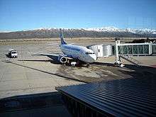
The city is served by San Carlos de Bariloche International Airport (IATA BRC/ICAO SAZS) equipped to receive any kind of aircraft. Several of Argentina's most important airlines maintain regular flights to Bariloche, as well as some international lines from neighbouring countries, especially during the ski season. The city is linked by train with the city of Viedma through the Tren Patagonico that crosses Argentina from the Andes to the Atlantic Ocean.
Bariloche can also be reached by buses and private cars. The main land route from North is RN 40 (ex 237) that enters from Neuquén and connects through Argentine's route system with Buenos Aires and rest of Argentina. Other options are, from the East, by Provincial Route 23 (partially paved), crossing the southern Patagonian line, or from the South by RN 40, coming from the town of El Bolsón. Currently, route RN 2455 (from Collon Cura) and route 258 are part of RN 40, former routes 237 and 258 are joined by the new Av. De Circunvalación North of the city
San Carlos de Bariloche lies close to the Chilean border and is connected to Chile by the Cardenal Antonio Samoré Pass crossing the Andes Mountains.
And finally, the city has a terminal railway station that links it to Viedma.
Internal Transportation
Within the city, Mibus is the single mass transit bus company that works, this bus line operates with the SUBE card. The Company Las Grutas that connects Bariloche with Dina Huapi also runs through part of the city, although this line operates with its own card.
Military
Bariloche is home of the army's "12° Regimiento de Infantería de Montaña" (12th Mountain Infantry Regiment), where military personnel are instructed in mountainous conditions, including combat, survival, and skiing. It is usual for the Regiment to receive infantry personnel from other parts of the country and train them. Furthermore, the Escuela Militar de Montaña, the mountain warfare school of the Argentine Army is located in Bariloche.[22]
Neighbourhoods
The main Neighbourhoods are Belgrano, Jardín Botánico, Melipal, Centro, Las Victorias, Las Marias, Dos Valles, and Playa Bonita.
Sports
The Andean Club Bariloche (Spanish: Club Andino Bariloche-CAB) was co-organiser of the 1st and the 3rd South American Ski Mountaineering Championships.
The Club Deportivo Cruz del Sur takes part in Torneo Federal B, the fourth tier of the Argentine football league system. The sides Estudiantes Unidos and Estrella del Sur also participated in lower Argentine leagues.
Sister cities
| Country | City | Reference |
|---|---|---|
| La Massana | [23] | |
| Gramado | [24] | |
| Osorno | [25] | |
| Puerto Montt | [25] | |
| Puerto Varas | [25] | |
| Belluno | [26] | |
| L'Aquila | [27] | |
| Sestriere | [28][29] | |
| Queenstown | [30] | |
| St. Moritz | [31] | |
| Aspen | [32] |
See also
- Club Andino Bariloche
- Ferrocarril General Roca
- Huemul Project
- Nahuel Huapi National Park
- Servicios Ferroviarios Patagónico
References
- https://www.anbariloche.com.ar/noticias/2010/11/25/17693-datos-provisorios-del-censo-bariloche-tiene-108205-habitantes
- http://poblacion.population.city/argentina/san-carlos-de-bariloche/
- https://web.archive.org/web/20100104095240/http://www.bariloche.com.ar/museo/MAPU.HTM
- https://web.archive.org/web/20100109160344/http://bariloche.com.ar/museo/DESTINO2.HTM
- Urbina, Ximena (2008). "The frustrated strategic mission of Nahuelhuapi, a point in Patagonia's immensity". Magallania. 36 (1): 5–30. Archived from the original on 18 February 2017. Retrieved 26 April 2013.
- Hanisch, Walter. 1974. Historia de la Compañía de Jesús en Chile, p. 33
- Urbina, Rodolfo (1990). "La rebelión indígena de 1712: los tributarios de Chiloé contra la encomienda" (PDF). Tiempo y Espacio (in Spanish). Chillán: El Departamento (1): 73–86.
- Muñoz Sougarret, Jorge (2014). "Relaciones de dependencia entre trabajadores y empresas chilenas situadas en el extranjero. San Carlos de Bariloche, Argentina (1895-1920)" [Dependence Relationships between Workers and Chilean Companies located abroad. San Car-los de Bariloche, Argentina (1895-1920)]. Trashumante: Revista Americana de Historia Social (in Spanish). 3: 74–95. Retrieved 3 January 2019.
- Tourism Policy in 20th-century Argentina
- "Un libro asegura que Hitler se refugió en la Patagonia".
- "Argentina - Bariloche Was Hitler and Eva Braun's Final Refuge".
- Bao, S. et al. 2014.Argentina Travel Guide. 9th Edition. Lonely Planet Publishing. 640 pp. ISBN 9781742207865
- "Clima de Bariloche y Río Manso Inferior" (in Spanish). Instituto Nacional de Tecnología Agropecuaria. Archived from the original on 11 October 2018. Retrieved 10 October 2018.
- "Estadísticas Climatológicas Normales - período 1981-2010" (in Spanish). Servicio Meteorológico Nacional. Retrieved 18 January 2018.
- Bustos, José; Rocchi, Victor. "Caracterizacíon Termopluviométrica de Algunas Estaciones Meteorológicas de Rio Negro Y Neuquén" (PDF) (in Spanish). Instituto Nacional de Tecnología Agropecuaria. pp. 5–7. Retrieved 26 June 2014.
- "INFORME ESPECIAL POR FRÍO EXTREMO Y NEVADAS: Período del 14 al 20 de julio de 2017" (PDF) (in Spanish). Servicio Meteorólogico Nacional. Retrieved 20 July 2017.
- "Fin de febrero: lo destacado del mes" (in Spanish). Servicio Meteorológico Nacional. Archived from the original on 4 March 2019. Retrieved 3 March 2019.
- "Bariloche Aero Climate Normals 1961–1990". National Oceanic and Atmospheric Administration. Retrieved 26 June 2014.
- "Bariloche, Rio Negro". Estadísticas meteorológicas decadiales (in Spanish). Oficina de Riesgo Agropecuario. Retrieved 20 June 2015.
- "Provincia de Rio Negro − Clima Y Meteorologia: Datos Meteorologicos Y Pluviometicos" (in Spanish). Secretaria de Mineria de la Nacion (Argentina). Archived from the original on 19 January 2015. Retrieved 7 April 2013.
- https://www.parkswatch.org/parkprofile.php?l=spa&country=arg&park=nhnp&page=ref
- http://www.ejercito.mil.ar/sitio/_noticias/noticia_full.asp?Id=814 (in Spanish), Argentine Army.
- "La Massana avança cap a l'agermanament amb Bariloche". El Periòdic d'Andorra (in Catalan). Retrieved 10 August 2019.
- "Cidades de Bariloche e Gramado buscam irmanação turística Caribbean News Digital". www.cndportugues.com (in Portuguese). Retrieved 10 August 2019.
- "ORDENANZA N.º 2884-CM-17". www.bariloche.gov.ar (in Spanish). Retrieved 10 August 2019.
- "Patto di amicizia Belluno - Bariloche Parte la delegazione veneta per l'Argentina". www.tribunaitaliana.com (in Italian). Retrieved 10 August 2019.
- "L'Aquila-Bariloche, si rinnova il gemellaggio". Il Capoluogo (in Italian). 17 July 2017. Retrieved 10 August 2019.
- "SESTRIERE: IL GEMELLAGGIO SESTRIERE-BARILOCHE E LA VISITA DEL PRESIDENTE MATTARELLA IN ARGENTINA". www.inaltavalledisusa.it (in Italian). Retrieved 10 August 2019.
- "Bariloche y Sestriere ya son "ciudades hermanas"". Diario Río Negro (in Spanish). 14 October 2002. Retrieved 10 August 2019.
- "Ordenanza 1135-I-94" (PDF) (in Spanish).
- "Concejo inauguró la Plaza Ciudades Hermanas". Bariloche 2000 (in Spanish). 11 December 2017. Retrieved 10 August 2019.
- "Aspen, CO - Bariloche, Argentina Sister Cities Agreement" (PDF). Retrieved 10 August 2019.
Notes
- The record highs and lows are based on the INTA link for the period 1951–1990 while records beyond 1990 come from the Oficina de Riesgo Agropecuario link since it only covers from 1970–present. As a result, the most extreme values from either source are used.
- In the Secretaria de Mineria and INTA link, the data from 1901-1950 corresponds to the data recorded in the downtown station (Bariloche Ciudad) while the data from 1951-1990 corresponds to the data recorded from the airport
External links
| Wikimedia Commons has media related to San Carlos de Bariloche. |
- (in Spanish and English) Bariloche Official Website
| Authority control |
|
|---|