Bardera
Bardhere City (Arabic: بااردىرآ, Somali: Bardhere) is an important agricultural city in Bardhere District, Gedo region of Somalia. It is the second most populous town in the Juba Valley, with Kismayo being the largest and most densely populated city in the region, and Garbahaarreey serving as Gedo's capital.
Bardera بااردىرآ Bardhere | |
|---|---|
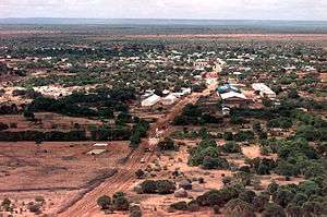 View over Bardera 1993 | |
| Nickname(s): Baladka raaxada | |
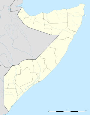 Bardera بااردىرآ Location in Somalia | |
| Coordinates: 2°20′N 42°17′E | |
| Country | |
| State | Jubaland |
| Region | Gedo |
| District | District |
| Government | |
| • Bardera District Commissioner | [Abdullahi Nor Hassan] |
| Population | |
| • Estimate (2018) | 12,000 |
| Time zone | UTC+3 (EAT) |
History
During the Middle Ages, Bardera and its surrounding area was part of the Ajuran Empire that governed much of southern Somalia and eastern Ethiopia, with its domain extending from Hobyo in the north, to Qelafo in the west, to Kismayo in the south.[2]
In the early modern period, Bardera was ruled by the Geledi Sultanate. The kingdom was eventually incorporated into Italian Somaliland protectorate in 1910 after the death of the last Sultan Osman Ahmed.[3] After independence in 1960, the city was made the center of the official Bardera District.
Climate
Bardera has a hot semi-arid climate (Köppen climate classification BSh).
| Climate data for Bardera | |||||||||||||
|---|---|---|---|---|---|---|---|---|---|---|---|---|---|
| Month | Jan | Feb | Mar | Apr | May | Jun | Jul | Aug | Sep | Oct | Nov | Dec | Year |
| Record high °C (°F) | 45.0 (113.0) |
45.0 (113.0) |
49.0 (120.2) |
46.0 (114.8) |
45.0 (113.0) |
46.0 (114.8) |
42.0 (107.6) |
39.0 (102.2) |
43.0 (109.4) |
44.0 (111.2) |
43.0 (109.4) |
43.0 (109.4) |
49.0 (120.2) |
| Average high °C (°F) | 38.2 (100.8) |
39.3 (102.7) |
41.4 (106.5) |
38.0 (100.4) |
35.6 (96.1) |
34.0 (93.2) |
32.5 (90.5) |
33.1 (91.6) |
34.9 (94.8) |
36.1 (97.0) |
35.9 (96.6) |
36.7 (98.1) |
36.3 (97.3) |
| Daily mean °C (°F) | 29.7 (85.5) |
30.6 (87.1) |
31.5 (88.7) |
30.4 (86.7) |
29.0 (84.2) |
27.7 (81.9) |
26.2 (79.2) |
26.8 (80.2) |
28.2 (82.8) |
29.1 (84.4) |
28.8 (83.8) |
29.1 (84.4) |
29.0 (84.2) |
| Average low °C (°F) | 21.4 (70.5) |
22.0 (71.6) |
22.9 (73.2) |
22.9 (73.2) |
22.6 (72.7) |
21.3 (70.3) |
20.4 (68.7) |
20.9 (69.6) |
21.5 (70.7) |
22.1 (71.8) |
21.7 (71.1) |
21.6 (70.9) |
21.8 (71.2) |
| Record low °C (°F) | 16.0 (60.8) |
17.0 (62.6) |
18.0 (64.4) |
18.0 (64.4) |
18.0 (64.4) |
16.5 (61.7) |
15.0 (59.0) |
12.0 (53.6) |
16.0 (60.8) |
18.5 (65.3) |
14.0 (57.2) |
16.0 (60.8) |
12.0 (53.6) |
| Average precipitation mm (inches) | 6 (0.2) |
6 (0.2) |
22 (0.9) |
93 (3.7) |
55 (2.2) |
15 (0.6) |
25 (1.0) |
7 (0.3) |
6 (0.2) |
63 (2.5) |
57 (2.2) |
29 (1.1) |
384 (15.1) |
| Average precipitation days (≥ 0.1 mm) | 1 | 1 | 3 | 8 | 5 | 3 | 4 | 2 | 1 | 5 | 6 | 4 | 43 |
| Average relative humidity (%) | 63 | 61 | 61 | 69 | 72 | 71 | 69 | 70 | 69 | 73 | 72 | 69 | 68 |
| Mean monthly sunshine hours | 285.2 | 262.7 | 291.4 | 228.0 | 235.6 | 207.0 | 186.0 | 226.3 | 231.0 | 213.9 | 219.0 | 254.2 | 2,840.3 |
| Mean daily sunshine hours | 9.2 | 9.3 | 9.4 | 7.6 | 7.6 | 6.9 | 6.0 | 7.3 | 7.7 | 6.9 | 7.3 | 8.2 | 7.8 |
| Percent possible sunshine | 80 | 80 | 73 | 55 | 55 | 55 | 55 | 55 | 64 | 55 | 64 | 73 | 64 |
| Source 1: Deutscher Wetterdienst[4] | |||||||||||||
| Source 2: Food and Agriculture Organization: Somalia Water and Land Management (percent sunshine)[5] | |||||||||||||
Health
Bardera's main district hospital has been closed due to disrepair and neglect since November 1995. Functioning health centers include Somali Red Crescent MCH, HIRDA MCH, West Bardera Maternity Unit and East Bardera Mothers and Children's Hospital, now Bardera Maternity Hospital.[6]
Notes
- "Archived copy". Archived from the original on 2011-07-08. Retrieved 2011-01-22.CS1 maint: archived copy as title (link)
- Lee V. Cassanelli, The shaping of Somali society: reconstructing the history of a pastoral people, 1600-1900, (University of Pennsylvania Press: 1982), p.102.
- Cassanelli, Lee Vincent (1973). The Benaadir Past: Essays in Southern Somali History. University Microfilms International. p. 149.
- "Klimatafel von Bardera / Somalia" (PDF). Baseline climate means (1961-1990) from stations all over the world (in German). Deutscher Wetterdienst. Retrieved 22 October 2016.
- "Long term mean monthly sunshine fraction in Somalia". Food and Agriculture Organization. Retrieved 4 November 2016.
- Bardera Maternity Hospital Archived 2010-01-02 at the Wayback Machine
References
- February 12, 2007 New Commissioner for Bardera
- Ethiopian Army Invaides Bardera Somalia
External links
| Wikimedia Commons has media related to Bardera. |
- Baardheere city portal (in Somali)
- Baardheere at Google Maps