Banavie railway station
Banavie railway station is a railway station on the West Highland Line serving the village of Banavie, although it is much closer to Caol, Scotland. To continue on to the next station at Corpach, trains must pass over the Caledonian Canal at Neptune's Staircase, a popular tourist attraction.
| Banavie | |
|---|---|
| Scottish Gaelic: Banbhaidh[1] | |
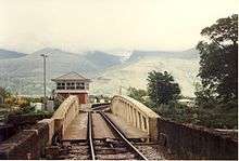
.jpg) The platform at Banavie with Ben Nevis's peak covered in cloud and snow. | |
| Location | |
| Place | Banavie |
| Local authority | Highland |
| Coordinates | 56.8439°N 5.0960°W |
| Grid reference | NN112767 |
| Operations | |
| Station code | BNV |
| Managed by | Abellio ScotRail |
| Number of platforms | 1 |
| Live arrivals/departures, station information and onward connections from National Rail Enquiries | |
| Annual rail passenger usage* | |
| 2014/15 | |
| 2015/16 | |
| 2016/17 | |
| 2017/18 | |
| 2018/19 | |
| History | |
| Original company | Mallaig Extension Railway of West Highland Railway |
| Pre-grouping | North British Railway |
| Post-grouping | LNER |
| 1 April 1901 | Station opened |
| National Rail – UK railway stations | |
| |
History
Banavie station opened along with the Mallaig Extension Railway on 1 April 1901.[2] It comprises a single platform on the north side of the line. The station was host to a LNER camping coach from 1936 to 1939.[3] Another station named "Banavie" existed above the Neptune's Staircase flight of locks that was renamed Banavie Pier railway station and closed to passengers in 1939. 'Banavie Junction' for the pier branch was located just to the south of the level crossing at Banavie.
Services
In the May 2019 timetable, four trains a day call here in either direction (plus steam specials, though these do not stop). Three of them are through trains to/from Glasgow Queen Street, whilst the other starts/finishes at Fort William and connects into/out of the sleeper service to London Euston.[4]
Services are operated by Abellio ScotRail.
| Preceding station | Following station | |||
|---|---|---|---|---|
| Fort William | Abellio ScotRail West Highland Line |
Corpach | ||
| Historical railways | ||||
| Fort William Line and Station open |
North British Railway Mallaig Extension Railway of West Highland Railway |
Corpach Line and Station open | ||
Signalling
From the time of its opening in 1901, the Mallaig Extension Railway was worked throughout by the electric token system. A signal box, named "Banavie Canal Bridge", was located at the west end of the station, on the north side of the line. It did not become a token station until 4 February 1912, but originally existed to control the nearby level crossings and the adjacent swing bridge over the Caledonian Canal.
Because of the continuing requirement to operate the swing bridge locally, Banavie was chosen as the location for the control centre for the West Highland Line's new radio signalling system. Banavie signalling centre opened on 14 June 1987 when it replaced the old Canal Bridge signal box. The Radio Electronic Token Block signalling was commissioned on 6 December 1987. The control centre covers train movements as far south as Helensburgh and Oban and Mallaig to the west. Local train movements in Fort William and the nearby freight yard at Inverlochy are controlled by the mechanical signal box at Fort William Junction.
References
Notes
- Brailsford 2017, Gaelic/English Station Index.
- Butt 1995, p. 26.
- McRae 1997, p. 11.
- Table 227 National Rail timetable, May 2019
Sources
- Brailsford, Martyn, ed. (December 2017) [1987]. Railway Track Diagrams 1: Scotland & Isle of Man (6th ed.). Frome: Trackmaps. ISBN 978-0-9549866-9-8.CS1 maint: ref=harv (link)
- Butt, R. V. J. (1995). The Directory of Railway Stations: details every public and private passenger station, halt, platform and stopping place, past and present (1st ed.). Sparkford: Patrick Stephens Ltd. ISBN 978-1-85260-508-7. OCLC 60251199.
- McRae, Andrew (1997). British Railway Camping Coach Holidays: The 1930s & British Railways (London Midland Region). Scenes from the Past: 30 (Part One). Foxline. ISBN 1-870119-48-7.
Further reading
- Jowett, Alan (March 1989). Jowett's Railway Atlas of Great Britain and Ireland: From Pre-Grouping to the Present Day (1st ed.). Sparkford: Patrick Stephens Ltd. ISBN 978-1-85260-086-0. OCLC 22311137.
- Jowett, Alan (2000). Jowett's Nationalised Railway Atlas (1st ed.). Penryn, Cornwall: Atlantic Transport Publishers. ISBN 978-0-906899-99-1. OCLC 228266687.