Balsac, Aveyron
Balsac is a village in the Aveyron department in the Occitanie region of southern France. It was merged into the new commune of Druelle Balsac on 1 January 2017.[1]
Balsac | |
|---|---|
Part of Druelle Balsac | |
Location of Balsac 
| |
 Balsac  Balsac | |
| Coordinates: 44°24′14″N 2°26′45″E | |
| Country | France |
| Region | Occitanie |
| Department | Aveyron |
| Arrondissement | Rodez |
| Canton | Vallon |
| Commune | Druelle Balsac |
| Area 1 | 15.57 km2 (6.01 sq mi) |
| Population (2010) | 611 |
| • Density | 39/km2 (100/sq mi) |
| Time zone | UTC+01:00 (CET) |
| • Summer (DST) | UTC+02:00 (CEST) |
| Postal code | 12510 |
| Elevation | 374–606 m (1,227–1,988 ft) (avg. 577 m or 1,893 ft) |
| 1 French Land Register data, which excludes lakes, ponds, glaciers > 1 km2 (0.386 sq mi or 247 acres) and river estuaries. | |
The inhabitants of the commune are known as Balsacois or Balsacoises.[2]
Geography
Balsac is located some 10 km north-west of Rodez and 8 km south-east of Saint-Christophe-Vallon, immediately west of Rodez–Marcillac Airport. Access to the commune is by the D598 which branches off the D57 west of the commune and passes through the village continuing to join the D840 south-east of the commune. The D626 goes north-east from the village to join the D840. The commune is entirely farmland.[3]
The Ruisseau des Parranies and its tributary the Ruisseau du Sauvage rise in the south of the commune and flow west then north-west, forming part of the western border of the commune, to join the Ruisseau de l'Ady west of the commune.[3]
Neighbouring communes and villages[3]
Places adjacent to Balsac, Aveyron | |
|---|---|
Administration
| From | To | Name | Party | Position |
|---|---|---|---|---|
| 1866 | 1868 | Louis Bernat | ||
| 1868 | 1874 | Auguste Bernat | ||
| 1874 | 1881 | Théophile Guizot | ||
| 1881 | 1888 | Adrien Vareilles | ||
| 1888 | 1907 | Auguste Bernat | ||
| 1907 | 1908 | Joseph Sanhes | ||
| 1908 | 1911 | Ernest Mercadier | ||
| 1911 | 1912 | Etienne Malaterre | ||
| 1912 | 1919 | Henri Molinier | ||
| 1919 | 1925 | Théophile Palayret | ||
| 1925 | 1935 | Casimir Molinie | ||
| 1935 | 1945 | Etienne Bonnefous | ||
| 1945 | 1947 | Marcel Palayret | ||
| 1947 | 1977 | Etienne Bonnefous | ||
| 1977 | 1995 | François Pons | ||
| 1995 | 2008 | Alain Gabriac | ||
| 2008 | 2020 | Daniel Raynal |
(Not all data is known)
Demography
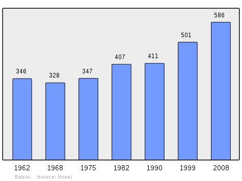
In 2010 the commune had 611 inhabitants. The evolution of the number of inhabitants is known from the population censuses conducted in the commune since 1793. From the 21st century, a census of communes with fewer than 10,000 inhabitants is held every five years, unlike larger communes that have a sample survey every year.[Note 1]
| 1793 | 1800 | 1806 | 1821 | 1831 | 1836 | 1841 | 1846 | 1851 |
|---|---|---|---|---|---|---|---|---|
| 591 | 461 | - | - | - | - | - | - | - |
| 1856 | 1861 | 1866 | 1872 | 1876 | 1881 | 1886 | 1891 | 1896 |
|---|---|---|---|---|---|---|---|---|
| - | - | 595 | 569 | 605 | 648 | 633 | 612 | 563 |
| 1901 | 1906 | 1911 | 1921 | 1926 | 1931 | 1936 | 1946 | 1954 |
|---|---|---|---|---|---|---|---|---|
| 536 | 520 | 481 | 434 | 407 | 411 | 402 | 400 | 361 |
| 1962 | 1968 | 1975 | 1982 | 1990 | 1999 | 2006 | 2010 | - |
|---|---|---|---|---|---|---|---|---|
| 346 | 328 | 347 | 407 | 411 | 501 | 565 | 611 | - |
Sites and monuments
There are two sites which are registered as historical monuments:
- The Ruins of the old Priory of Sauvage (13th century)

- The Chateau of Balsac (14th - 16th centuries)
- The Parish Church contains three items that are registered as historical objects:
See also
Bibliography
- Christian-Pierre Bedel, preface by José Monestier, Marcilhac, Balsac, Claravals, Moret, Muret, Nòuviala, Prunas, Salas-Comtals, Sent-Cristòfa, Valadin / Christian-Pierre Bedel e los estatjants del canton de Marcilhac, Rodez, Mission départementale de la culture, 2001, Al canton collection, 392 pages, ill., cov. ill.; 28 cm, ISBN 2-907279-52-1, ISSN 1151-8375, BnF 38803935q (in French)
External links
- Balsac on the old National Geographic Institute website (in French)
- Balsac on Lion1906
- Balsac on Géoportail, National Geographic Institute (IGN) website (in French)
- Balſac on the 1750 Cassini Map
- Balsac on the INSEE website (in French)
Notes and references
Notes
- At the beginning of the 21st century, the methods of identification have been modified by Law No. 2002-276 of 27 February 2002 Archived 6 March 2016 at the Wayback Machine, the so-called "law of local democracy" and in particular Title V "census operations" allows, after a transitional period running from 2004 to 2008, the annual publication of the legal population of the different French administrative districts. For communes with a population greater than 10,000 inhabitants, a sample survey is conducted annually, the entire territory of these communes is taken into account at the end of the period of five years. The first "legal population" after 1999 under this new law came into force on 1 January 2009 and was based on the census of 2006.
References
- Arrêté préfectoral 6 September 2016 (in French)
- Inhabitants of Aveyron (in French)
- Google Maps
- List of Mayors of France (in French)
- Ministry of Culture, Mérimée PA00093961 Ruins of the old Priory of Sauvage (in French)
- Ministry of Culture, Mérimée PA12000040 Chateau (in French)
- "Home - Le Donjon du Château". Le Donjon du Château. Retrieved 2018-01-20.
- Ministry of Culture, Palissy PM12000016 Statue: Virgin and child (in French)

- Ministry of Culture, Palissy PM12000018 Statue: Saint Antoine (in French)
- Ministry of Culture, Palissy PM12000017 Statue: Saint Foy (in French)
| Wikimedia Commons has media related to Balsac. |
| Authority control |
|
|---|