Baldoyle Bay
Baldoyle Bay is a sea inlet on the east coast of Fingal in Ireland, in the historic County Dublin. It is situated between Portmarnock and Baldoyle. The bay is an important natural feature with protected status, which once held a Viking longphort.
| Baldoyle Bay | |
|---|---|
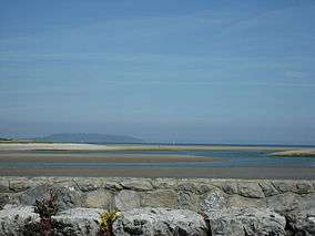 View from Strand Road | |
 Location in Ireland | |
| Location | Fingal, Ireland |
| Nearest city | Baldoyle |
| Coordinates | 53.401°N 6.1245°W |
| Established | 1988 |
| Designated | 25 October 1988 |
| Reference no. | 413[1] |
Nature
The narrow inlet runs north–south, reaching the sea north of Howth Head along the Burrow Beach. It is bounded on the seaward side by the peninsula on which the Velvet Strand (used as a runway for early flights) and the Portmarnock Golf Club course are situated. It contains the estuaries of two small rivers, the Sluice at the northern, Portmarnock, end, and the Mayne, mid-way south, at the north end of Baldoyle.
The inlet contains both freshwater and saltwater marshes, as well as raised salt marsh, mud and sand, and riverine shallows and creeks. Four habitat types feature in Annex I of the EU Habitats Directive, namely Salicornia mud, Mediterranean salt meadows, Atlantic salt meadows and tidal mudflats. Much of the intertidal flats are exposed at low tide, mostly sand but also some muds in the inner estuary.
Notable flora include common cord-grass, narrow-leafed eelgrass, dwarf eelgrass, and, in summer, green algae.
Baldoyle Bay is an important coastal site, used by wintering wildfowl and waders and other birds. It is a Special Protection Area,[2] cared for by the local authority and National Parks and Wildlife Service.
Declared a Statutory Nature Reserve in 1988,[3] the inner, estuarine, parts of the bay are protected as a Special Area of Conservation (SAC)[4] while, under the Ramsar Convention, the wetlands have been designated as of international importance. They support several habitats that are listed in the EU Habitats Directive.[5] It is part of the Dublin Bay Biosphere Reserve.
History
The Baldoyle area was raided and later settled by the "dark-haired foreigners" (Danish Vikings), who found the bay convenient for their long-boats, with their shallow draft - the Mayne River and related streams provided fresh water.
Access
The estuary is paralleled by a coastal road to the west and north, served by bus, and with few possibilities for parking. To the east, access is possible on foot from parking for Portmarnock's southern beaches. A small park exists at the northern end of the estuary, and is itself popular with birds. It holds an interpretative sign with information on the area. There is also a walking route to the estuary from Clongriffin.
References
- "Baldoyle Bay". Ramsar Sites Information Service. Retrieved 25 April 2018.
- National Parks and Wildlife Service (Ireland), Baldoyle Bay SPA, 004016
- Irish Statute Book, S.I. No. 233/1988 — Nature Reserve (Baldoyle Estuary) Establishment Order, 1988
- Natural Heritage Designations, Baldoyle Bay
- Habitats Directive, Environmental Legislation